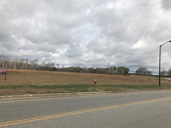
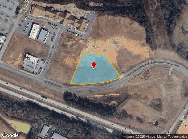
Property Record
Gateway Ln, Bethlehem, GA 30620
NEARBY LISTINGS FOR SALE OR LEASE
Property Detail
Gateway Ln
WN16-020Q
TRACT 10 PB 64-65
Commercialacreage
Barrow
X
Georgia
13013C0128D
2.85 AC
2025
Barrow County
2025
Atlanta
180503
Atlanta-Sandy Springs-Roswell, GA
DEMOGRAPHICS near Gateway Ln
1 mile
3 mile
5 mile
2024 Total Population
2,148
18,129
47,718
2029 Population
2,494
21,199
55,541
Pop Growth 2024-2029
+ 16.11%
+ 16.93%
+ 16.39%
Average Age
36
35
37
2024 Total Households
745
5,871
16,217
HH Growth 2024-2029
+ 16.11%
+ 17.08%
+ 16.58%
Median Household Inc
$59,782
$67,142
$65,109
Avg Household Size
2.80
3.00
2.90
2024 Avg HH Vehicles
2.00
2.00
2.00
Median Home Value
$234,951
$209,261
$214,316
Median Year Built
1998
2002
1999
Nearby Places
Map Layers
Map Styles
 Street
 Aerial
Transit
 Traffic
 Biking
Places
Listings with unknown addresses are not visible on the map
- Restaurants
- Banks
- Shops
- Fitness
- Groceries
SALE & LEASE HISTORY
LISTING DATE
SALE/LEASE

Jul 22, 2022
For Sale
Aug 02, 2017
For Sale
Nearby Properties
Address
Land Use
TOTAL SIZE
Lot Size
Zoning
Address
Land Use
TOTAL SIZE
Lot Size
Zoning
1,456 SF
1,732.81 AC
G
Address
Land Use
TOTAL SIZE
Lot Size
Zoning
6,424 SF
11.63 AC
B-2,R-3
Address
Land Use
TOTAL SIZE
Lot Size
Zoning
26,789 SF
35.64 AC
C-3
Address
Land Use
TOTAL SIZE
Lot Size
Zoning
22,320 SF
15.90 AC
R-3
Address
Land Use
TOTAL SIZE
Lot Size
Zoning
120,000 SF
142.73 AC
AG
Address
Land Use
TOTAL SIZE
Lot Size
Zoning
2,046 SF
12.97 AC
B-2,R-3
Address
Land Use
TOTAL SIZE
Lot Size
Zoning
37,012 SF
10.55 AC
OI
Address
Land Use
TOTAL SIZE
Lot Size
Zoning
104,805 SF
12.54 AC
C-3
Address
Land Use
TOTAL SIZE
Lot Size
Zoning
2,398 SF
8.13 AC
R-3
Address
Land Use
TOTAL SIZE
Lot Size
Zoning
132,156 SF
10.05 AC
C-2
Address
Land Use
TOTAL SIZE
Lot Size
Zoning
1,188 SF
7.63 AC
R-3
Address
Land Use
TOTAL SIZE
Lot Size
Zoning
79,029 SF
9.72 AC
C-2
Address
Land Use
TOTAL SIZE
Lot Size
Zoning
65,340 SF
11.81 AC
C-3
Address
Land Use
TOTAL SIZE
Lot Size
Zoning
3,370 SF
352.38 AC
G,TNPD
Address
Land Use
TOTAL SIZE
Lot Size
Zoning
60,540 SF
79.35 AC
AG
Address
Land Use
TOTAL SIZE
Lot Size
Zoning
38,550 SF
3.04 AC
C-2
Address
Land Use
TOTAL SIZE
Lot Size
Zoning
37,162 SF
4.62 AC
R-3
Address
Land Use
TOTAL SIZE
Lot Size
Zoning
55,420 SF
5.05 AC
C-3
Address
Land Use
TOTAL SIZE
Lot Size
Zoning
26,802 SF
5 AC
AG
Address
Land Use
TOTAL SIZE
Lot Size
Zoning
24,982 SF
16.08 AC
R-1
Address
Land Use
TOTAL SIZE
Lot Size
Zoning
8,916 SF
67.07 AC
R-3
Address
Land Use
TOTAL SIZE
Lot Size
Zoning
105.99 AC
C-3
Address
Land Use
TOTAL SIZE
Lot Size
Zoning
46,339 SF
2 AC
B-2
Address
Land Use
TOTAL SIZE
Lot Size
Zoning
20,592 SF
66.11 AC
G
Address
Land Use
TOTAL SIZE
Lot Size
Zoning
76,768 SF
19.04 AC
AG
Address
Land Use
TOTAL SIZE
Lot Size
Zoning
45,296 SF
8.18 AC
B-2
Address
Land Use
TOTAL SIZE
Lot Size
Zoning
143,025 SF
9.30 AC
M-1
Address
Land Use
TOTAL SIZE
Lot Size
Zoning
19,483 SF
2.76 AC
B-2
Address
Land Use
TOTAL SIZE
Lot Size
Zoning
34,355 SF
24.48 AC
AG
Address
Land Use
TOTAL SIZE
Lot Size
Zoning
17.90 AC
R-3
The World's #1 Commercial Real Estate Marketplace
Connect with us
© 2026 CoStar Group
The information above has been obtained from sources believed reliable. While we do not doubt its accuracy we have not verified it and make no guarantee, warranty or representation about it. It is your responsibility to independently confirm its accuracy and completeness. Any projections, opinions, assumptions, or estimates used are for example only and do not represent the current or future performance of the property. The value of this transaction to you depends on tax and other factors which should be evaluated by your tax, financial, and legal advisors. You and your advisors should conduct a careful, independent investigation of the property to determine to your satisfaction the suitability of the property for your needs.