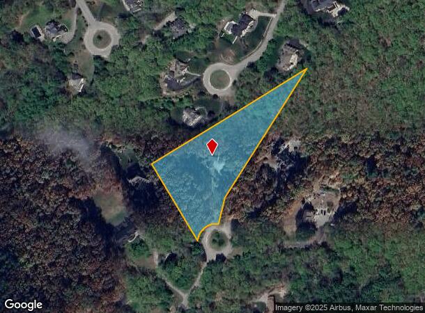
Property Record
53 Sharon Rd, Windham, NH 03087
This Property Is For Sale
NEARBY LISTINGS FOR SALE OR LEASE
-
-
View all Windham listings for sale on LoopNet.com
Property Detail
53 Sharon Rd
Boston-Cambridge-Newton, MA-NH
Rockingham
WNDM-000025-D000000-000042
New Hampshire
Sfr
3.59 AC
X
Rockingham
33011C0543D
Boston
3,711 SF
DEMOGRAPHICS near 53 Sharon Rd
1 Mile
3 Mile
5 Mile
2024 Total Population
2,318
16,716
59,123
2029 Population
2,402
17,290
61,129
Pop Growth 2024-2029
+ 3.62%
+ 3.43%
+ 3.39%
Average Age
39
42
43
2024 Total Households
722
5,810
21,822
HH Growth 2024-2029
+ 3.46%
+ 3.37%
+ 3.57%
Median Household Inc
$180,619
$136,603
$123,662
Avg Household Size
3.10
2.80
2.70
2024 Avg HH Vehicles
3.00
2.00
2.00
Median Home Value
$685,882
$523,352
$454,361
Median Year Built
1991
1985
1984
Nearby Places
Map Layers
Map Styles
 Street
 Aerial
- Restaurants
- Banks
- Shops
- Fitness
- Groceries
PUBLIC TRANSPORTATION
AIRPORT
Manchester Boston Regional
DRIVE
WALK
Distance
Manchester Boston Regional
39 min
20.7 mi
General Edward Lawrence Logan International
DRIVE
WALK
Distance
General Edward Lawrence Logan International
63 min
42.7 mi
Portsmouth International at Pease
DRIVE
WALK
Distance
Portsmouth International at Pease
71 min
45.2 mi
Nearby Properties
Address
Land Use
TOTAL SIZE
Lot Size
Zoning
Address
Land Use
TOTAL SIZE
Lot Size
Zoning
75.16 AC
CIB
Address
Land Use
TOTAL SIZE
Lot Size
Zoning
195,778 SF
101.88 AC
RD
Address
Land Use
TOTAL SIZE
Lot Size
Zoning
72.18 AC
CIB
Address
Land Use
TOTAL SIZE
Lot Size
Zoning
58,339 SF
47.49 AC
RD
Address
Land Use
TOTAL SIZE
Lot Size
Zoning
50,048 SF
8.81 AC
CIB
Address
Land Use
TOTAL SIZE
Lot Size
Zoning
13,158 SF
52.40 AC
VCD
Address
Land Use
TOTAL SIZE
Lot Size
Zoning
113,388 SF
16.28 AC
CIB
Address
Land Use
TOTAL SIZE
Lot Size
Zoning
66,543 SF
6.74 AC
CIB
Address
Land Use
TOTAL SIZE
Lot Size
Zoning
71,854 SF
26 AC
RD
Address
Land Use
TOTAL SIZE
Lot Size
Zoning
155,040 SF
16.36 AC
IND
Address
Land Use
TOTAL SIZE
Lot Size
Zoning
2.15 AC
R
Address
Land Use
TOTAL SIZE
Lot Size
Zoning
63,628 SF
34.21 AC
CDA
Address
Land Use
TOTAL SIZE
Lot Size
Zoning
11.49 AC
CIB
Address
Land Use
TOTAL SIZE
Lot Size
Zoning
72,868 SF
6.58 AC
IND
Address
Land Use
TOTAL SIZE
Lot Size
Zoning
64,896 SF
11.68 AC
IND
Address
Land Use
TOTAL SIZE
Lot Size
Zoning
59,626 SF
7.40 AC
VCD
Address
Land Use
TOTAL SIZE
Lot Size
Zoning
99,833 SF
15.26 AC
IND
Address
Land Use
TOTAL SIZE
Lot Size
Zoning
52,648 SF
7.68 AC
CIB
Address
Land Use
TOTAL SIZE
Lot Size
Zoning
19 AC
MUZD
Address
Land Use
TOTAL SIZE
Lot Size
Zoning
73,048 SF
18.73 AC
CIB
Address
Land Use
TOTAL SIZE
Lot Size
Zoning
41,388 SF
3.86 AC
CIB
Address
Land Use
TOTAL SIZE
Lot Size
Zoning
49,340 SF
9.22 AC
IND
Address
Land Use
TOTAL SIZE
Lot Size
Zoning
47,240 SF
3.44 AC
CIB
Address
Land Use
TOTAL SIZE
Lot Size
Zoning
72,495 SF
5.39 AC
CIB
Address
Land Use
TOTAL SIZE
Lot Size
Zoning
61,252 SF
4.52 AC
IND
Address
Land Use
TOTAL SIZE
Lot Size
Zoning
13,673 SF
11.76 AC
CDA
Address
Land Use
TOTAL SIZE
Lot Size
Zoning
46,044 SF
2.63 AC
CIB
Address
Land Use
TOTAL SIZE
Lot Size
Zoning
11,412 SF
4.21 AC
CDA
Address
Land Use
TOTAL SIZE
Lot Size
Zoning
34,911 SF
2.90 AC
CIB
Address
Land Use
TOTAL SIZE
Lot Size
Zoning
27,057 SF
3.38 AC
MUZD
The World's #1 Commercial Real Estate Marketplace
Connect with us
© 2026 CoStar Group
The information above has been obtained from sources believed reliable. While we do not doubt its accuracy we have not verified it and make no guarantee, warranty or representation about it. It is your responsibility to independently confirm its accuracy and completeness. Any projections, opinions, assumptions, or estimates used are for example only and do not represent the current or future performance of the property. The value of this transaction to you depends on tax and other factors which should be evaluated by your tax, financial, and legal advisors. You and your advisors should conduct a careful, independent investigation of the property to determine to your satisfaction the suitability of the property for your needs.