Property Record
Geiger Grade Rd, Reno, NV 89521

Property Detail
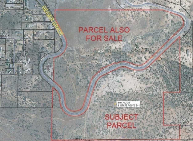
Geiger Grade Rd
016-762-20
FRAC NW4
Residentialacreage
WASHOE
MDS 13% /
Nevada
B and X Area of moderate flood hazard, usually the area between the limits of the 100-year and 500-year floods.
69 AC
2025
S Outlying Washoe County
2026
Reno/Sparks
002219
Reno, NV
NEARBY LISTINGS FOR SALE OR LEASE
DEMOGRAPHICS near Geiger Grade Rd
1 mile
3 mile
5 mile
2025 Total Population
1,250
18,434
54,295
2030 Population
1,302
19,595
56,472
Pop Growth 2025-2030
+ 4.16%
+ 6.30%
+ 4.01%
Average Age
46
41
42
2025 Total Households
481
6,872
21,447
HH Growth 2025-2030
+ 4.37%
+ 6.46%
+ 4.01%
Median Household Inc
$85,901
$108,141
$121,156
Avg Household Size
2.60
2.70
2.50
2025 Avg HH Vehicles
3.00
2.00
2.00
Median Home Value
$693,859
$708,939
$730,321
Median Year Built
1993
2006
2005
Nearby Places
Map Layers
Map Styles
 Street
 Aerial
Transit
 Traffic
 Biking
Places
Listings with unknown addresses are not visible on the map
- Restaurants
- Banks
- Shops
- Fitness
- Groceries
PUBLIC TRANSPORTATION
AIRPORT
Reno/Tahoe International
Drive
Walk
Distance
Reno/Tahoe International
36 min
14.3 mi
Freight Ports
Port of Stockton
Drive
Walk
Distance
Port of Stockton
228 min
193.5 mi
Nearby Properties
Address
Land Use
TOTAL SIZE
Lot Size
Zoning
Address
Land Use
TOTAL SIZE
Lot Size
Zoning
430,526 SF
14.79 AC
MS
Address
Land Use
TOTAL SIZE
Lot Size
Zoning
410,834 SF
11.58 AC
MS
Address
Land Use
TOTAL SIZE
Lot Size
Zoning
181,150 SF
27.71 AC
PD
Address
Land Use
TOTAL SIZE
Lot Size
Zoning
379,347 SF
18.42 AC
MS
Address
Land Use
TOTAL SIZE
Lot Size
Zoning
257,652 SF
23.36 AC
MS
Address
Land Use
TOTAL SIZE
Lot Size
Zoning
283,103 SF
10.02 AC
PD
Address
Land Use
TOTAL SIZE
Lot Size
Zoning
276,780 SF
60.26 AC
PD
Address
Land Use
TOTAL SIZE
Lot Size
Zoning
392,820 SF
24.82 AC
MS
Address
Land Use
TOTAL SIZE
Lot Size
Zoning
110,100 SF
22.88 AC
MS
Address
Land Use
TOTAL SIZE
Lot Size
Zoning
167,612 SF
7.88 AC
PD
Address
Land Use
TOTAL SIZE
Lot Size
Zoning
86,329 SF
9.32 AC
PD
Address
Land Use
TOTAL SIZE
Lot Size
Zoning
60,947 SF
47.04 AC
MS
Address
Land Use
TOTAL SIZE
Lot Size
Zoning
79,736 SF
1.57 AC
MS
Address
Land Use
TOTAL SIZE
Lot Size
Zoning
45,604 SF
10.20 AC
SF3
Address
Land Use
TOTAL SIZE
Lot Size
Zoning
196,560 SF
10.58 AC
MS
Address
Land Use
TOTAL SIZE
Lot Size
Zoning
190,063 SF
11.94 AC
MS
Address
Land Use
TOTAL SIZE
Lot Size
Zoning
145,600 SF
14.06 AC
MS
Address
Land Use
TOTAL SIZE
Lot Size
Zoning
32.24 AC
MS
Address
Land Use
TOTAL SIZE
Lot Size
Zoning
94,594 SF
8.30 AC
MS
Address
Land Use
TOTAL SIZE
Lot Size
Zoning
28.61 AC
PD
Address
Land Use
TOTAL SIZE
Lot Size
Zoning
51,425 SF
10.04 AC
PSP
Address
Land Use
TOTAL SIZE
Lot Size
Zoning
26.94 AC
PD
Address
Land Use
TOTAL SIZE
Lot Size
Zoning
19,969 SF
0.65 AC
MS
Address
Land Use
TOTAL SIZE
Lot Size
Zoning
8,575 SF
2.67 AC
PD
Address
Land Use
TOTAL SIZE
Lot Size
Zoning
14.48 AC
MS
Address
Land Use
TOTAL SIZE
Lot Size
Zoning
12.60 AC
PD
Address
Land Use
TOTAL SIZE
Lot Size
Zoning
11.66 AC
MS
Address
Land Use
TOTAL SIZE
Lot Size
Zoning
19.67 AC
MS
Address
Land Use
TOTAL SIZE
Lot Size
Zoning
94,781 SF
21.80 AC
NC
Address
Land Use
TOTAL SIZE
Lot Size
Zoning
20.90 AC
MS
The World's #1 Commercial Real Estate Marketplace
Connect with us
© 2026 CoStar Group
The information above has been obtained from sources believed reliable. While we do not doubt its accuracy we have not verified it and make no guarantee, warranty or representation about it. It is your responsibility to independently confirm its accuracy and completeness. Any projections, opinions, assumptions, or estimates used are for example only and do not represent the current or future performance of the property. The value of this transaction to you depends on tax and other factors which should be evaluated by your tax, financial, and legal advisors. You and your advisors should conduct a careful, independent investigation of the property to determine to your satisfaction the suitability of the property for your needs.