Property Record
Gender Rd, Columbus Grove, OH 45830
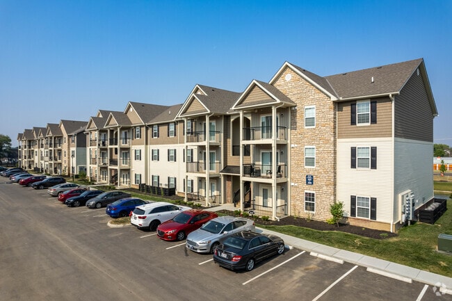


Property Detail
Gender Rd
Columbus, OH
GENDER RD R21 T11 S12 10.575 ACRES
010-301943
FRANKLIN
Apartment
Ohio
2024
10.58 AC
2025
Canal Winchester
030500
Columbus
46,340 SF
NEARBY LISTINGS FOR SALE OR LEASE
-
-
View all Columbus Grove listings for sale on LoopNet.com
DEMOGRAPHICS near Gender Rd
1 mile
3 mile
5 mile
2025 Total Population
7,023
67,371
166,274
2030 Population
7,244
69,866
172,511
Pop Growth 2025-2030
+ 3.15%
+ 3.70%
+ 3.75%
Average Age
34
37
38
2025 Total Households
2,998
25,208
63,902
HH Growth 2025-2030
+ 3.44%
+ 3.77%
+ 3.85%
Median Household Inc
$58,033
$72,993
$71,945
Avg Household Size
2.30
2.60
2.50
2025 Avg HH Vehicles
2.00
2.00
2.00
Median Home Value
$217,742
$255,650
$274,612
Median Year Built
2004
1997
1990
Nearby Places
Map Layers
Map Styles
 Street
 Aerial
Transit
 Traffic
 Biking
Places
Listings with unknown addresses are not visible on the map
- Restaurants
- Banks
- Shops
- Fitness
- Groceries
PUBLIC TRANSPORTATION
AIRPORT
Rickenbacker International
Drive
Walk
Distance
Rickenbacker International
20 min
12.2 mi
John Glenn Columbus International
Drive
Walk
Distance
John Glenn Columbus International
22 min
13.1 mi
Freight Ports
Port of Toledo
Drive
Walk
Distance
Port of Toledo
198 min
156.8 mi
Nearby Properties
Address
Land Use
TOTAL SIZE
Lot Size
Zoning
Address
Land Use
TOTAL SIZE
Lot Size
Zoning
106,679 SF
35.60 AC
Address
Land Use
TOTAL SIZE
Lot Size
Zoning
756,088 SF
52.66 AC
Address
Land Use
TOTAL SIZE
Lot Size
Zoning
61,542 SF
29.16 AC
Address
Land Use
TOTAL SIZE
Lot Size
Zoning
65,760 SF
25.37 AC
Address
Land Use
TOTAL SIZE
Lot Size
Zoning
553,548 SF
46.23 AC
Address
Land Use
TOTAL SIZE
Lot Size
Zoning
450,264 SF
34.81 AC
Address
Land Use
TOTAL SIZE
Lot Size
Zoning
230,994 SF
23.82 AC
Address
Land Use
TOTAL SIZE
Lot Size
Zoning
307,190 SF
55.18 AC
Address
Land Use
TOTAL SIZE
Lot Size
Zoning
181,204 SF
22.90 AC
Address
Land Use
TOTAL SIZE
Lot Size
Zoning
68,492 SF
23.63 AC
Address
Land Use
TOTAL SIZE
Lot Size
Zoning
528,750 SF
42.14 AC
Address
Land Use
TOTAL SIZE
Lot Size
Zoning
253,530 SF
66.22 AC
Address
Land Use
TOTAL SIZE
Lot Size
Zoning
374,220 SF
Address
Land Use
TOTAL SIZE
Lot Size
Zoning
60,005 SF
0.35 AC
Address
Land Use
TOTAL SIZE
Lot Size
Zoning
446,160 SF
91.12 AC
Address
Land Use
TOTAL SIZE
Lot Size
Zoning
446,160 SF
22.71 AC
Address
Land Use
TOTAL SIZE
Lot Size
Zoning
122,938 SF
29.37 AC
Address
Land Use
TOTAL SIZE
Lot Size
Zoning
136,440 SF
5.38 AC
Address
Land Use
TOTAL SIZE
Lot Size
Zoning
263,120 SF
23.12 AC
Address
Land Use
TOTAL SIZE
Lot Size
Zoning
69,070 SF
20.06 AC
Address
Land Use
TOTAL SIZE
Lot Size
Zoning
46,737 SF
26.70 AC
Address
Land Use
TOTAL SIZE
Lot Size
Zoning
29,311 SF
24.95 AC
Address
Land Use
TOTAL SIZE
Lot Size
Zoning
33,230 SF
28.79 AC
Address
Land Use
TOTAL SIZE
Lot Size
Zoning
259,616 SF
23.54 AC
Address
Land Use
TOTAL SIZE
Lot Size
Zoning
22,368 SF
23.08 AC
Address
Land Use
TOTAL SIZE
Lot Size
Zoning
29,569 SF
0.34 AC
Address
Land Use
TOTAL SIZE
Lot Size
Zoning
59,296 SF
7.91 AC
Address
Land Use
TOTAL SIZE
Lot Size
Zoning
141,966 SF
40.45 AC
Address
Land Use
TOTAL SIZE
Lot Size
Zoning
209,250 SF
12.03 AC
The World's #1 Commercial Real Estate Marketplace
Connect with us
© 2026 CoStar Group
The information above has been obtained from sources believed reliable. While we do not doubt its accuracy we have not verified it and make no guarantee, warranty or representation about it. It is your responsibility to independently confirm its accuracy and completeness. Any projections, opinions, assumptions, or estimates used are for example only and do not represent the current or future performance of the property. The value of this transaction to you depends on tax and other factors which should be evaluated by your tax, financial, and legal advisors. You and your advisors should conduct a careful, independent investigation of the property to determine to your satisfaction the suitability of the property for your needs.