Property Record
General Delivery, Warner Robins, GA 31088
NEARBY LISTINGS FOR SALE OR LEASE
Property Detail
General Delivery
Warner Robins, GA
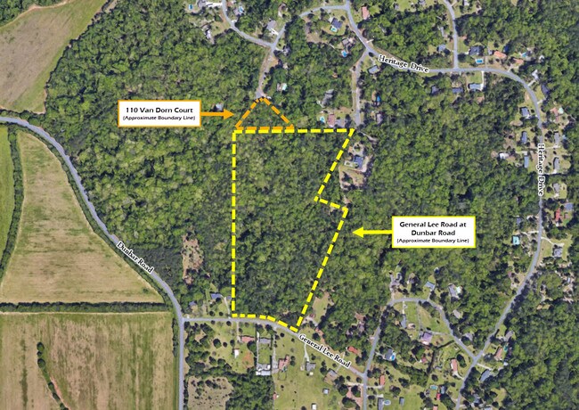
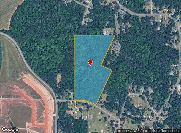
Tract B Heritage S/D
00071A033000
TRACT B HERITAGE S/D 135/5TH
Residentialacreage
Houston
X
Georgia
13021C0245G
24.51 AC
2024
Perry/Warner Robins
2024
Other Market Areas
021119
DEMOGRAPHICS near General Delivery
1 Mile
3 Mile
5 Mile
2024 Total Population
1,993
32,164
77,584
2029 Population
2,150
35,120
84,444
Pop Growth 2024-2029
+ 7.88%
+ 9.19%
+ 8.84%
Average Age
42
39
38
2024 Total Households
797
12,857
30,897
HH Growth 2024-2029
+ 7.65%
+ 8.94%
+ 8.66%
Median Household Inc
$61,262
$54,897
$56,578
Avg Household Size
2.50
2.50
2.40
2024 Avg HH Vehicles
2.00
2.00
2.00
Median Home Value
$129,775
$134,002
$137,247
Median Year Built
1981
1982
1983
Nearby Places
Map Layers
Map Styles
 Street
 Aerial
- Restaurants
- Banks
- Shops
- Fitness
- Groceries
SALE & LEASE HISTORY
LISTING DATE
SALE/LEASE

Nov 13, 2018
For Sale
Mar 17, 2020
For Sale
Nearby Properties
Address
Land Use
TOTAL SIZE
Lot Size
Zoning
Address
Land Use
TOTAL SIZE
Lot Size
Zoning
17,952 SF
1,075.78 AC
M-1
Address
Land Use
TOTAL SIZE
Lot Size
Zoning
780,000 SF
70.50 AC
M-2
Address
Land Use
TOTAL SIZE
Lot Size
Zoning
11,088 SF
59.57 AC
M-2
Address
Land Use
TOTAL SIZE
Lot Size
Zoning
11,658 SF
30.23 AC
R2
Address
Land Use
TOTAL SIZE
Lot Size
Zoning
226,032 SF
49.90 AC
C2
Address
Land Use
TOTAL SIZE
Lot Size
Zoning
11,056 SF
17.41 AC
R4
Address
Land Use
TOTAL SIZE
Lot Size
Zoning
304,246 SF
23.11 AC
C2
Address
Land Use
TOTAL SIZE
Lot Size
Zoning
92,930 SF
18.66 AC
C2
Address
Land Use
TOTAL SIZE
Lot Size
Zoning
158,300 SF
29.99 AC
R1
Address
Land Use
TOTAL SIZE
Lot Size
Zoning
21,750 SF
11.48 AC
C2
Address
Land Use
TOTAL SIZE
Lot Size
Zoning
223,608 SF
22.40 AC
C2
Address
Land Use
TOTAL SIZE
Lot Size
Zoning
6,336 SF
27.16 AC
R4
Address
Land Use
TOTAL SIZE
Lot Size
Zoning
194,390 SF
242 AC
A
Address
Land Use
TOTAL SIZE
Lot Size
Zoning
128,540 SF
32.26 AC
R2
Address
Land Use
TOTAL SIZE
Lot Size
Zoning
139,016 SF
24.71 AC
C2
Address
Land Use
TOTAL SIZE
Lot Size
Zoning
20,252 SF
22.87 AC
A
Address
Land Use
TOTAL SIZE
Lot Size
Zoning
132,851 SF
24.05 AC
C2
Address
Land Use
TOTAL SIZE
Lot Size
Zoning
90,000 SF
12 AC
R1
Address
Land Use
TOTAL SIZE
Lot Size
Zoning
125,412 SF
9.82 AC
C2
Address
Land Use
TOTAL SIZE
Lot Size
Zoning
61,628 SF
45 AC
C2
Address
Land Use
TOTAL SIZE
Lot Size
Zoning
5,400 SF
16.21 AC
R4
Address
Land Use
TOTAL SIZE
Lot Size
Zoning
108,500 SF
10.85 AC
C2
Address
Land Use
TOTAL SIZE
Lot Size
Zoning
4,720 SF
12.53 AC
C2
Address
Land Use
TOTAL SIZE
Lot Size
Zoning
108,075 SF
10.55 AC
R2
Address
Land Use
TOTAL SIZE
Lot Size
Zoning
113,895 SF
10 AC
M-1
Address
Land Use
TOTAL SIZE
Lot Size
Zoning
62,600 SF
4.35 AC
C2
Address
Land Use
TOTAL SIZE
Lot Size
Zoning
44,400 SF
8.28 AC
C2
Address
Land Use
TOTAL SIZE
Lot Size
Zoning
4,720 SF
8.66 AC
C2
Address
Land Use
TOTAL SIZE
Lot Size
Zoning
2,880 SF
16.49 AC
PUD
Address
Land Use
TOTAL SIZE
Lot Size
Zoning
3,200 SF
17.67 AC
R2
The World's #1 Commercial Real Estate Marketplace
Connect with us
© 2025 CoStar Group
The information above has been obtained from sources believed reliable. While we do not doubt its accuracy we have not verified it and make no guarantee, warranty or representation about it. It is your responsibility to independently confirm its accuracy and completeness. Any projections, opinions, assumptions, or estimates used are for example only and do not represent the current or future performance of the property. The value of this transaction to you depends on tax and other factors which should be evaluated by your tax, financial, and legal advisors. You and your advisors should conduct a careful, independent investigation of the property to determine to your satisfaction the suitability of the property for your needs.