Property Record
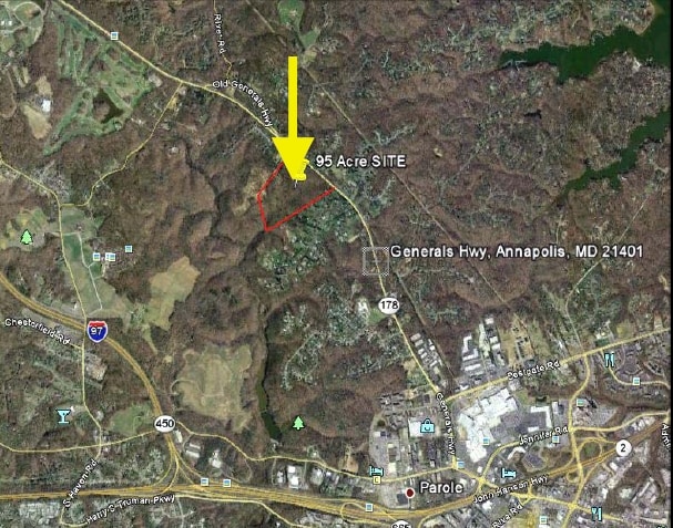
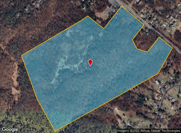
Generals Hwy, Annapolis, MD 21401

NEARBY LISTINGS FOR SALE OR LEASE
-
-
View all Annapolis listings for sale on LoopNet.com
Property Detail
Generals Hwy
02-000-90012184
Rosa V Johnson Property
Taxexempt
95.63 ACRES GENERALS HWY ROSA V JOHNSON PROPERTY
A
Anne Arundel
24003C0164F
Maryland
2023
95.63 AC
2025
Annapolis
706600
Baltimore
4,580 SF
Baltimore-Columbia-Towson, MD
DEMOGRAPHICS near Generals Hwy
1 Mile
3 Mile
5 Mile
2024 Total Population
3,232
33,811
110,299
2029 Population
3,307
34,652
113,190
Pop Growth 2024-2029
+ 2.32%
+ 2.49%
+ 2.62%
Average Age
46
45
42
2024 Total Households
1,424
14,611
44,046
HH Growth 2024-2029
+ 2.25%
+ 2.53%
+ 2.72%
Median Household Inc
$129,948
$119,500
$120,885
Avg Household Size
2.20
2.20
2.40
2024 Avg HH Vehicles
2.00
2.00
2.00
Median Home Value
$699,894
$546,844
$560,167
Median Year Built
1989
1987
1980
Nearby Places
Map Layers
Map Styles
 Street
 Aerial
- Restaurants
- Banks
- Shops
- Fitness
- Groceries
PUBLIC TRANSPORTATION
AIRPORT
Baltimore/Washington International Thurgood Marshall
DRIVE
WALK
Distance
Baltimore/Washington International Thurgood Marshall
29 min
18.5 mi
Ronald Reagan Washington Ntl
DRIVE
WALK
Distance
Ronald Reagan Washington Ntl
49 min
35.1 mi
Freight Ports
Port of Baltimore
DRIVE
WALK
Distance
Port of Baltimore
36 min
24.0 mi
Nearby Properties
Address
Land Use
TOTAL SIZE
Lot Size
Zoning
Address
Land Use
TOTAL SIZE
Lot Size
Zoning
2,568,175 SF
55.32 AC
TC
Address
Land Use
TOTAL SIZE
Lot Size
Zoning
717,491 SF
26.28 AC
C2
Address
Land Use
TOTAL SIZE
Lot Size
Zoning
296,790 SF
27.74 AC
TC
Address
Land Use
TOTAL SIZE
Lot Size
Zoning
313,440 SF
23.43 AC
TC
Address
Land Use
TOTAL SIZE
Lot Size
Zoning
441,482 SF
3.85 AC
W1
Address
Land Use
TOTAL SIZE
Lot Size
Zoning
577,560 SF
3.71 AC
C2
Address
Land Use
TOTAL SIZE
Lot Size
Zoning
346,335 SF
16.42 AC
R22
Address
Land Use
TOTAL SIZE
Lot Size
Zoning
419,712 SF
9.48 AC
R2
Address
Land Use
TOTAL SIZE
Lot Size
Zoning
389,081 SF
4.79 AC
TC
Address
Land Use
TOTAL SIZE
Lot Size
Zoning
271,003 SF
1 AC
TC
Address
Land Use
TOTAL SIZE
Lot Size
Zoning
365,268 SF
4.85 AC
W1
Address
Land Use
TOTAL SIZE
Lot Size
Zoning
97,888 SF
59.42 AC
C2
Address
Land Use
TOTAL SIZE
Lot Size
Zoning
429.57 AC
OS
Address
Land Use
TOTAL SIZE
Lot Size
Zoning
341,468 SF
1.82 AC
TC
Address
Land Use
TOTAL SIZE
Lot Size
Zoning
435,081 SF
2.62 AC
TC
Address
Land Use
TOTAL SIZE
Lot Size
Zoning
315,260 SF
22.82 AC
C2
Address
Land Use
TOTAL SIZE
Lot Size
Zoning
194,155 SF
6.69 AC
R1
Address
Land Use
TOTAL SIZE
Lot Size
Zoning
254,969 SF
13.73 AC
W1A
Address
Land Use
TOTAL SIZE
Lot Size
Zoning
286,262 SF
62.34 AC
RA
Address
Land Use
TOTAL SIZE
Lot Size
Zoning
73.33 AC
R2
Address
Land Use
TOTAL SIZE
Lot Size
Zoning
104,950 SF
2.93 AC
TC
Address
Land Use
TOTAL SIZE
Lot Size
Zoning
389,242 SF
11.56 AC
C2
Address
Land Use
TOTAL SIZE
Lot Size
Zoning
175,294 SF
13.82 AC
W1
Address
Land Use
TOTAL SIZE
Lot Size
Zoning
25,990 SF
32.06 AC
C2
Address
Land Use
TOTAL SIZE
Lot Size
Zoning
160,914 SF
20.63 AC
TC
Address
Land Use
TOTAL SIZE
Lot Size
Zoning
Address
Land Use
TOTAL SIZE
Lot Size
Zoning
Address
Land Use
TOTAL SIZE
Lot Size
Zoning
Address
Land Use
TOTAL SIZE
Lot Size
Zoning
Address
Land Use
TOTAL SIZE
Lot Size
Zoning
The World's #1 Commercial Real Estate Marketplace
Connect with us
© 2026 CoStar Group
The information above has been obtained from sources believed reliable. While we do not doubt its accuracy we have not verified it and make no guarantee, warranty or representation about it. It is your responsibility to independently confirm its accuracy and completeness. Any projections, opinions, assumptions, or estimates used are for example only and do not represent the current or future performance of the property. The value of this transaction to you depends on tax and other factors which should be evaluated by your tax, financial, and legal advisors. You and your advisors should conduct a careful, independent investigation of the property to determine to your satisfaction the suitability of the property for your needs.