Property Record
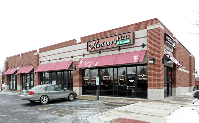
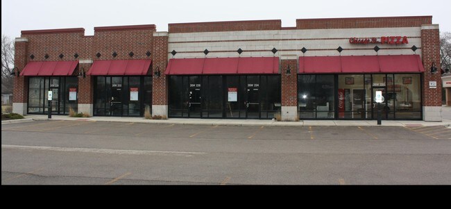
Geneva Rd, Winfield, IL 60190

Property Detail
Geneva Rd
05-06-404-015
CVS SUB ALL
Commercialnec
DUPAGE
C
Illinois
B and X Area of moderate flood hazard, usually the area between the limits of the 100-year and 500-year floods.
2
2024
1.44 AC
2024
Western East/West Corr
841403
Chicago
7,400 SF
Chicago-Naperville-Elgin, IL-IN
NEARBY LISTINGS FOR SALE OR LEASE
-
-
-
No Photo
-
-
-
-
-
-
View all Winfield listings for sale on LoopNet.com
DEMOGRAPHICS near Geneva Rd
1 mile
3 mile
5 mile
2025 Total Population
9,400
88,998
230,331
2030 Population
9,220
89,562
231,874
Pop Growth 2025-2030
(1.91%)
+ 0.63%
+ 0.67%
Average Age
42
41
40
2025 Total Households
3,215
32,005
81,330
HH Growth 2025-2030
(1.96%)
+ 0.71%
+ 0.68%
Median Household Inc
$156,470
$109,941
$109,991
Avg Household Size
2.80
2.60
2.70
2025 Avg HH Vehicles
2.00
2.00
2.00
Median Home Value
$441,013
$365,481
$366,130
Median Year Built
1983
1978
1977
Nearby Places
Map Layers
Map Styles
 Street
 Aerial
Transit
 Traffic
 Biking
Places
Listings with unknown addresses are not visible on the map
- Restaurants
- Banks
- Shops
- Fitness
- Groceries
PUBLIC TRANSPORTATION
COMMUTER RAIL
Winfield Station (Union Pacific West Line - Northeast Illinois Regional Commuter Railroad (Metra))
Drive
Walk
Distance
Winfield Station (Union Pacific West Line - Northeast Illinois Regional Commuter Railroad (Metra))
6 min
2.5 mi
Wheaton Station (Union Pacific West Line - Northeast Illinois Regional Commuter Railroad (Metra))
Drive
Walk
Distance
Wheaton Station (Union Pacific West Line - Northeast Illinois Regional Commuter Railroad (Metra))
7 min
2.8 mi
AIRPORT
Chicago O'Hare International
Drive
Walk
Distance
Chicago O'Hare International
48 min
19.3 mi
Chicago Midway International
Drive
Walk
Distance
Chicago Midway International
52 min
27.5 mi
Nearby Properties
Address
Land Use
TOTAL SIZE
Lot Size
Zoning
Address
Land Use
TOTAL SIZE
Lot Size
Zoning
818,262 SF
13.70 AC
M
Address
Land Use
TOTAL SIZE
Lot Size
Zoning
594,125 SF
2.60 AC
Address
Land Use
TOTAL SIZE
Lot Size
Zoning
545,570 SF
22.66 AC
C
Address
Land Use
TOTAL SIZE
Lot Size
Zoning
260,424 SF
16.87 AC
M
Address
Land Use
TOTAL SIZE
Lot Size
Zoning
268,400 SF
15.87 AC
M
Address
Land Use
TOTAL SIZE
Lot Size
Zoning
26,302 SF
2.09 AC
C
Address
Land Use
TOTAL SIZE
Lot Size
Zoning
Address
Land Use
TOTAL SIZE
Lot Size
Zoning
146,492 SF
0.42 AC
Address
Land Use
TOTAL SIZE
Lot Size
Zoning
235,131 SF
14.18 AC
I
Address
Land Use
TOTAL SIZE
Lot Size
Zoning
258,793 SF
16.44 AC
M
Address
Land Use
TOTAL SIZE
Lot Size
Zoning
9.34 AC
M
Address
Land Use
TOTAL SIZE
Lot Size
Zoning
216,720 SF
12.40 AC
M
Address
Land Use
TOTAL SIZE
Lot Size
Zoning
290,280 SF
14 AC
Address
Land Use
TOTAL SIZE
Lot Size
Zoning
204,464 SF
16.53 AC
Address
Land Use
TOTAL SIZE
Lot Size
Zoning
515,497 SF
21.98 AC
I
Address
Land Use
TOTAL SIZE
Lot Size
Zoning
149,460 SF
10.62 AC
M
Address
Land Use
TOTAL SIZE
Lot Size
Zoning
367,020 SF
26.13 AC
I
Address
Land Use
TOTAL SIZE
Lot Size
Zoning
582,089 SF
41.71 AC
C
Address
Land Use
TOTAL SIZE
Lot Size
Zoning
381,600 SF
24.47 AC
Address
Land Use
TOTAL SIZE
Lot Size
Zoning
304,976 SF
23.98 AC
Address
Land Use
TOTAL SIZE
Lot Size
Zoning
165,528 SF
16.08 AC
M
Address
Land Use
TOTAL SIZE
Lot Size
Zoning
436,765 SF
7 AC
M
Address
Land Use
TOTAL SIZE
Lot Size
Zoning
311,052 SF
20.97 AC
M
Address
Land Use
TOTAL SIZE
Lot Size
Zoning
393,516 SF
18.08 AC
I
Address
Land Use
TOTAL SIZE
Lot Size
Zoning
352,089 SF
21.13 AC
I
Address
Land Use
TOTAL SIZE
Lot Size
Zoning
6.20 AC
M
Address
Land Use
TOTAL SIZE
Lot Size
Zoning
302,986 SF
16.04 AC
Address
Land Use
TOTAL SIZE
Lot Size
Zoning
166,382 SF
10.50 AC
R-4
Address
Land Use
TOTAL SIZE
Lot Size
Zoning
334,718 SF
15.95 AC
I
Address
Land Use
TOTAL SIZE
Lot Size
Zoning
327,858 SF
15.10 AC
I
The World's #1 Commercial Real Estate Marketplace
Connect with us
© 2026 CoStar Group
The information above has been obtained from sources believed reliable. While we do not doubt its accuracy we have not verified it and make no guarantee, warranty or representation about it. It is your responsibility to independently confirm its accuracy and completeness. Any projections, opinions, assumptions, or estimates used are for example only and do not represent the current or future performance of the property. The value of this transaction to you depends on tax and other factors which should be evaluated by your tax, financial, and legal advisors. You and your advisors should conduct a careful, independent investigation of the property to determine to your satisfaction the suitability of the property for your needs.