Property Record
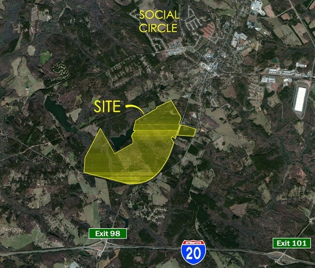
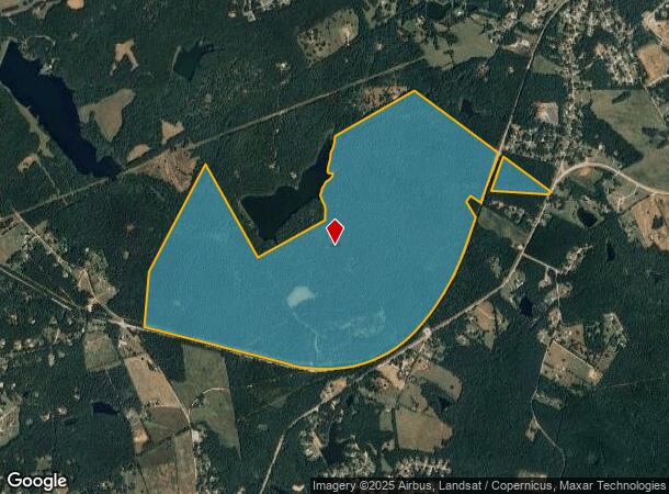
Strouds Creek Rd, Social Circle, GA 30025
NEARBY LISTINGS FOR SALE OR LEASE
-
-
View all Social Circle listings for sale on LoopNet.com
Property Detail
Strouds Creek Rd
Atlanta-Sandy Springs-Roswell, GA
Alcovy Oaks/Cochran Rd & Jenkins Rd
0111000000005000
716.34 AC LL146 LD1
Privatepreserveopenspacevacantlandforestlandconservation
Newton
X
Georgia
13297C0240F
146
2025
716.34 AC
2025
Newton County
110802
Atlanta
DEMOGRAPHICS near Strouds Creek Rd
1 Mile
3 Mile
5 Mile
2024 Total Population
335
7,617
15,042
2029 Population
375
8,751
17,096
Pop Growth 2024-2029
+ 11.94%
+ 14.89%
+ 13.66%
Average Age
42
40
40
2024 Total Households
119
2,701
5,336
HH Growth 2024-2029
+ 11.76%
+ 15.25%
+ 14.02%
Median Household Inc
$112,037
$90,450
$92,352
Avg Household Size
2.80
2.80
2.80
2024 Avg HH Vehicles
2.00
2.00
2.00
Median Home Value
$288,371
$276,528
$289,645
Median Year Built
1994
1997
1996
Nearby Places
Map Layers
Map Styles
 Street
 Aerial
- Restaurants
- Banks
- Shops
- Fitness
- Groceries
SALE & LEASE HISTORY
LISTING DATE
SALE/LEASE

Feb 23, 2022
For Sale
Nearby Properties
Address
Land Use
TOTAL SIZE
Lot Size
Zoning
Address
Land Use
TOTAL SIZE
Lot Size
Zoning
846,540 SF
102.62 AC
MCMUBP
Address
Land Use
TOTAL SIZE
Lot Size
Zoning
1,299,643 SF
89.54 AC
LI
Address
Land Use
TOTAL SIZE
Lot Size
Zoning
90,861 SF
1.24 AC
Address
Land Use
TOTAL SIZE
Lot Size
Zoning
96,984 SF
2.09 AC
OI
Address
Land Use
TOTAL SIZE
Lot Size
Zoning
4,239 SF
453.35 AC
A1
Address
Land Use
TOTAL SIZE
Lot Size
Zoning
117,648 SF
27.53 AC
OI
Address
Land Use
TOTAL SIZE
Lot Size
Zoning
2,240 SF
109.79 AC
HI WP2
Address
Land Use
TOTAL SIZE
Lot Size
Zoning
90,861 SF
96.67 AC
E6
Address
Land Use
TOTAL SIZE
Lot Size
Zoning
56,497 SF
9.32 AC
OI
Address
Land Use
TOTAL SIZE
Lot Size
Zoning
226.27 AC
Address
Land Use
TOTAL SIZE
Lot Size
Zoning
2,023 SF
19.54 AC
OI
Address
Land Use
TOTAL SIZE
Lot Size
Zoning
9,900 SF
8.16 AC
AG WP2
Address
Land Use
TOTAL SIZE
Lot Size
Zoning
20,607 SF
20.09 AC
A
Address
Land Use
TOTAL SIZE
Lot Size
Zoning
120,000 SF
14.10 AC
LI WP2
Address
Land Use
TOTAL SIZE
Lot Size
Zoning
96,000 SF
13.40 AC
LI WP2
Address
Land Use
TOTAL SIZE
Lot Size
Zoning
7,936 SF
8 AC
LI WP2
Address
Land Use
TOTAL SIZE
Lot Size
Zoning
2,660 SF
23.72 AC
LI WP2
Address
Land Use
TOTAL SIZE
Lot Size
Zoning
10,868 SF
28.61 AC
OI
Address
Land Use
TOTAL SIZE
Lot Size
Zoning
38,590 SF
8.54 AC
OI WP2
Address
Land Use
TOTAL SIZE
Lot Size
Zoning
31,995 SF
9.05 AC
GC
Address
Land Use
TOTAL SIZE
Lot Size
Zoning
3,392 SF
116.98 AC
AG WP2
Address
Land Use
TOTAL SIZE
Lot Size
Zoning
60,000 SF
2.89 AC
LI WP2
Address
Land Use
TOTAL SIZE
Lot Size
Zoning
13,420 SF
20 AC
E2
Address
Land Use
TOTAL SIZE
Lot Size
Zoning
8,760 SF
7.49 AC
LI WP2
Address
Land Use
TOTAL SIZE
Lot Size
Zoning
45.95 AC
CH
Address
Land Use
TOTAL SIZE
Lot Size
Zoning
50,000 SF
3.44 AC
LI WP2
Address
Land Use
TOTAL SIZE
Lot Size
Zoning
223.99 AC
A
Address
Land Use
TOTAL SIZE
Lot Size
Zoning
9,100 SF
1.96 AC
Address
Land Use
TOTAL SIZE
Lot Size
Zoning
10,548 SF
4.16 AC
GC WP2
The World's #1 Commercial Real Estate Marketplace
Connect with us
© 2025 CoStar Group
The information above has been obtained from sources believed reliable. While we do not doubt its accuracy we have not verified it and make no guarantee, warranty or representation about it. It is your responsibility to independently confirm its accuracy and completeness. Any projections, opinions, assumptions, or estimates used are for example only and do not represent the current or future performance of the property. The value of this transaction to you depends on tax and other factors which should be evaluated by your tax, financial, and legal advisors. You and your advisors should conduct a careful, independent investigation of the property to determine to your satisfaction the suitability of the property for your needs.