Property Record
Gerken Rd, Rosenberg, TX 77471

Property Detail
Gerken Rd
Houston-Pasadena-The Woodlands, TX
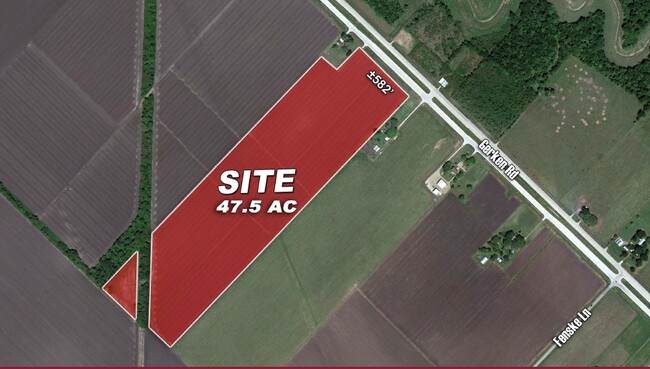
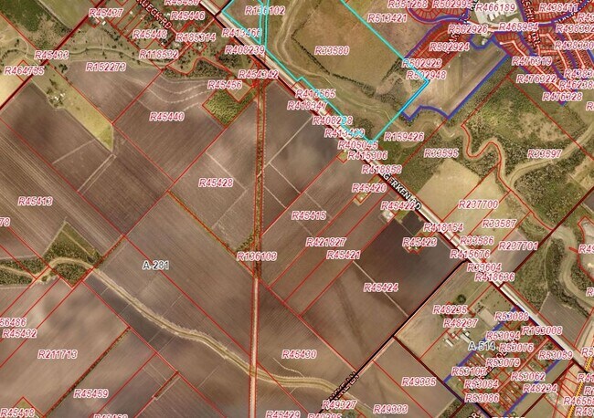
0281 WM LEECH, TRACT 2, ACRES 47.5
0281-00-000-0020-901
FORT BEND
Farms
Texas
QS
2
C and X Area of minimal flood hazard, usually depicted on FIRMs as above the 500-year flood level.
47.50 AC
2024
Southwest Outlier
2025
Houston
675300
NEARBY LISTINGS FOR SALE OR LEASE
DEMOGRAPHICS near Gerken Rd
1 mile
3 mile
5 mile
2024 Total Population
1,527
11,899
32,983
2029 Population
1,861
14,462
39,925
Pop Growth 2024-2029
+ 21.87%
+ 21.54%
+ 21.05%
Average Age
35
35
36
2024 Total Households
448
3,619
10,623
HH Growth 2024-2029
+ 22.32%
+ 22.08%
+ 21.57%
Median Household Inc
$81,395
$68,638
$65,914
Avg Household Size
3.20
3.20
3.10
2024 Avg HH Vehicles
2.00
2.00
2.00
Median Home Value
$248,113
$244,372
$209,115
Median Year Built
2010
2008
2001
Nearby Places
Map Layers
Map Styles
 Street
 Aerial
Transit
 Traffic
 Biking
Places
Listings with unknown addresses are not visible on the map
- Restaurants
- Banks
- Shops
- Fitness
- Groceries
SALE & LEASE HISTORY
LISTING DATE
SALE/LEASE

Mar 30, 2021
For Sale
Nearby Properties
Address
Land Use
TOTAL SIZE
Lot Size
Zoning
Address
Land Use
TOTAL SIZE
Lot Size
Zoning
146.35 AC
ST
Address
Land Use
TOTAL SIZE
Lot Size
Zoning
672 SF
230.34 AC
YT
Address
Land Use
TOTAL SIZE
Lot Size
Zoning
Address
Land Use
TOTAL SIZE
Lot Size
Zoning
25.69 AC
Address
Land Use
TOTAL SIZE
Lot Size
Zoning
208.52 AC
OST
Address
Land Use
TOTAL SIZE
Lot Size
Zoning
30.57 AC
Address
Land Use
TOTAL SIZE
Lot Size
Zoning
30.46 AC
S
Address
Land Use
TOTAL SIZE
Lot Size
Zoning
72,400 SF
10 AC
Address
Land Use
TOTAL SIZE
Lot Size
Zoning
21,867 SF
70.17 AC
Address
Land Use
TOTAL SIZE
Lot Size
Zoning
109.89 AC
YQ
Address
Land Use
TOTAL SIZE
Lot Size
Zoning
1,965 SF
170.82 AC
SOYK
Address
Land Use
TOTAL SIZE
Lot Size
Zoning
111.59 AC
QOY
Address
Land Use
TOTAL SIZE
Lot Size
Zoning
Address
Land Use
TOTAL SIZE
Lot Size
Zoning
864 SF
80.11 AC
QYSN
Address
Land Use
TOTAL SIZE
Lot Size
Zoning
10 AC
S
Address
Land Use
TOTAL SIZE
Lot Size
Zoning
50,000 SF
13 AC
Address
Land Use
TOTAL SIZE
Lot Size
Zoning
49,725 SF
3.57 AC
Address
Land Use
TOTAL SIZE
Lot Size
Zoning
15.19 AC
Address
Land Use
TOTAL SIZE
Lot Size
Zoning
2.53 AC
Address
Land Use
TOTAL SIZE
Lot Size
Zoning
55,325 SF
2.50 AC
SY
Address
Land Use
TOTAL SIZE
Lot Size
Zoning
45.10 AC
STR
Address
Land Use
TOTAL SIZE
Lot Size
Zoning
1,076 SF
80.30 AC
QY
Address
Land Use
TOTAL SIZE
Lot Size
Zoning
57.02 AC
Address
Land Use
TOTAL SIZE
Lot Size
Zoning
93.42 AC
Address
Land Use
TOTAL SIZE
Lot Size
Zoning
14.81 AC
OS
Address
Land Use
TOTAL SIZE
Lot Size
Zoning
3.90 AC
Address
Land Use
TOTAL SIZE
Lot Size
Zoning
29 AC
SQT
Address
Land Use
TOTAL SIZE
Lot Size
Zoning
1,600 SF
16.39 AC
OS
Address
Land Use
TOTAL SIZE
Lot Size
Zoning
1.42 AC
Address
Land Use
TOTAL SIZE
Lot Size
Zoning
47.50 AC
S
The World's #1 Commercial Real Estate Marketplace
Connect with us
© 2026 CoStar Group
The information above has been obtained from sources believed reliable. While we do not doubt its accuracy we have not verified it and make no guarantee, warranty or representation about it. It is your responsibility to independently confirm its accuracy and completeness. Any projections, opinions, assumptions, or estimates used are for example only and do not represent the current or future performance of the property. The value of this transaction to you depends on tax and other factors which should be evaluated by your tax, financial, and legal advisors. You and your advisors should conduct a careful, independent investigation of the property to determine to your satisfaction the suitability of the property for your needs.