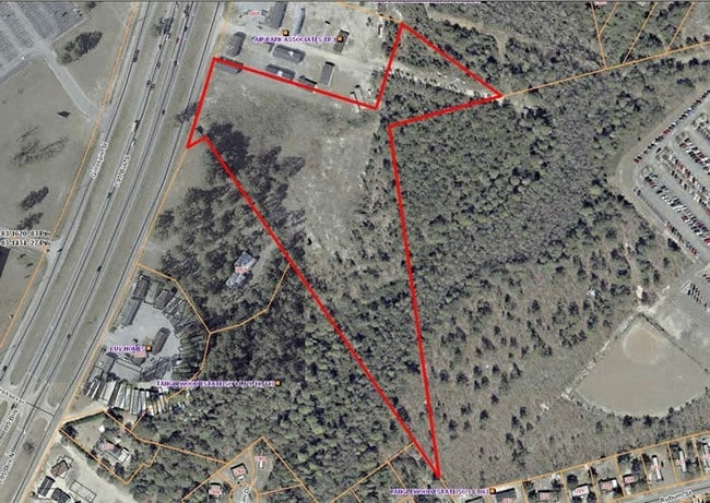
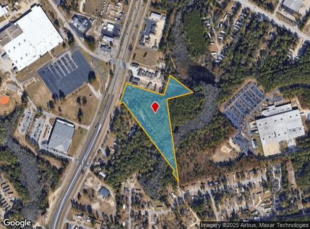
Property Record
Gillespie St, Fayetteville, NC 28306
This Property Is For Sale
NEARBY LISTINGS FOR SALE OR LEASE
Property Detail
Gillespie St
Fayetteville, NC
E. West Mountain/301 South
0435-03-1004
TOP OF THE HILL/CEDAR CREEK CROSSING LO:1D SE:01 PL:0114-0096
Commercialacreage
Cumberland
X
North Carolina
3720043500J
1d
2025
9.49 AC
2025
Downtown Fayetteville
001603
Fayetteville
DEMOGRAPHICS near Gillespie St
1 Mile
3 Mile
5 Mile
2024 Total Population
5,368
39,057
95,680
2029 Population
5,549
39,551
96,025
Pop Growth 2024-2029
+ 3.37%
+ 1.26%
+ 0.36%
Average Age
39
39
38
2024 Total Households
2,262
16,497
40,622
HH Growth 2024-2029
+ 3.58%
+ 1.25%
+ 0.33%
Median Household Inc
$41,329
$40,342
$43,719
Avg Household Size
2.00
2.20
2.20
2024 Avg HH Vehicles
1.00
1.00
2.00
Median Home Value
$174,807
$167,401
$153,214
Median Year Built
1969
1970
1976
Nearby Places
Map Layers
Map Styles
 Street
 Aerial
- Restaurants
- Banks
- Shops
- Fitness
- Groceries
PUBLIC TRANSPORTATION
COMMUTER RAIL
Fayetteville Amtrak Station (Palmetto - Amtrak, Silver Meteor - Amtrak)
DRIVE
WALK
Distance
Fayetteville Amtrak Station (Palmetto - Amtrak, Silver Meteor - Amtrak)
7 min
4.7 mi
AIRPORT
Fayetteville Regional/Grannis Field
DRIVE
WALK
Distance
Fayetteville Regional/Grannis Field
3 min
1.4 mi
Freight Ports
Port of Wilmington
DRIVE
WALK
Distance
Port of Wilmington
125 min
90.1 mi
Nearby Properties
Address
Land Use
TOTAL SIZE
Lot Size
Zoning
Address
Land Use
TOTAL SIZE
Lot Size
Zoning
47,832 SF
43.28 AC
CC
Address
Land Use
TOTAL SIZE
Lot Size
Zoning
1,377 SF
20.14 AC
MR5-MIXED
Address
Land Use
TOTAL SIZE
Lot Size
Zoning
4,947 SF
937.13 AC
MA
Address
Land Use
TOTAL SIZE
Lot Size
Zoning
56,622 SF
104.70 AC
R10
Address
Land Use
TOTAL SIZE
Lot Size
Zoning
6,670 SF
7.11 AC
CC
Address
Land Use
TOTAL SIZE
Lot Size
Zoning
14,000 SF
97.50 AC
MP
Address
Land Use
TOTAL SIZE
Lot Size
Zoning
191,495 SF
21.41 AC
CC
Address
Land Use
TOTAL SIZE
Lot Size
Zoning
500,548 SF
45.12 AC
MP
Address
Land Use
TOTAL SIZE
Lot Size
Zoning
47,279 SF
19.56 AC
LC
Address
Land Use
TOTAL SIZE
Lot Size
Zoning
2,860 SF
16.90 AC
SF10
Address
Land Use
TOTAL SIZE
Lot Size
Zoning
49.27 AC
MP-PLND IN
Address
Land Use
TOTAL SIZE
Lot Size
Zoning
77,650 SF
47.37 AC
CC
Address
Land Use
TOTAL SIZE
Lot Size
Zoning
3,480 SF
21.10 AC
MR5
Address
Land Use
TOTAL SIZE
Lot Size
Zoning
365,607 SF
59.08 AC
HI
Address
Land Use
TOTAL SIZE
Lot Size
Zoning
136,504 SF
18.74 AC
HI
Address
Land Use
TOTAL SIZE
Lot Size
Zoning
21.10 AC
MP
Address
Land Use
TOTAL SIZE
Lot Size
Zoning
88,383 SF
13.30 AC
CC
Address
Land Use
TOTAL SIZE
Lot Size
Zoning
16.41 AC
MP
Address
Land Use
TOTAL SIZE
Lot Size
Zoning
9,404 SF
62.05 AC
RR
Address
Land Use
TOTAL SIZE
Lot Size
Zoning
35,242 SF
56.61 AC
MP
Address
Land Use
TOTAL SIZE
Lot Size
Zoning
51,180 SF
26 AC
R6
Address
Land Use
TOTAL SIZE
Lot Size
Zoning
2,347 SF
7.22 AC
R5A
Address
Land Use
TOTAL SIZE
Lot Size
Zoning
2,636 SF
14.81 AC
R5A
Address
Land Use
TOTAL SIZE
Lot Size
Zoning
1,970 SF
5.04 AC
R5A
Address
Land Use
TOTAL SIZE
Lot Size
Zoning
58,915 SF
18.75 AC
MP
Address
Land Use
TOTAL SIZE
Lot Size
Zoning
32,893 SF
5.60 AC
CC
Address
Land Use
TOTAL SIZE
Lot Size
Zoning
1,935 SF
10.99 AC
MR5
Address
Land Use
TOTAL SIZE
Lot Size
Zoning
672 SF
6.20 AC
NC-NBHD CO
Address
Land Use
TOTAL SIZE
Lot Size
Zoning
5,880 SF
6.87 AC
SF6
Address
Land Use
TOTAL SIZE
Lot Size
Zoning
17,317 SF
15.30 AC
R10
The World's #1 Commercial Real Estate Marketplace
Connect with us
© 2026 CoStar Group
The information above has been obtained from sources believed reliable. While we do not doubt its accuracy we have not verified it and make no guarantee, warranty or representation about it. It is your responsibility to independently confirm its accuracy and completeness. Any projections, opinions, assumptions, or estimates used are for example only and do not represent the current or future performance of the property. The value of this transaction to you depends on tax and other factors which should be evaluated by your tax, financial, and legal advisors. You and your advisors should conduct a careful, independent investigation of the property to determine to your satisfaction the suitability of the property for your needs.