Property Record
0 Glenwood Rd, Rossford, OH 43460
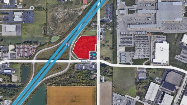
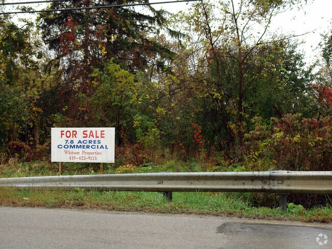

This Property Is For Sale
NEARBY LISTINGS FOR SALE OR LEASE
Property Detail
0 Glenwood Rd
Toledo, OH
Perrysburg Sec 26
T68-300-260101018000
USR 03-26 IRREG 1.25A PT COM 738.98 N SE COR NW
Recreationalacreage
Wood
X
Ohio
39173C0033D
1.25 AC
2023
Perrysburg/Northwood
2024
Toledo
020300
DEMOGRAPHICS near 0 Glenwood Rd
1 Mile
3 Mile
5 Mile
2024 Total Population
2,535
34,234
134,837
2029 Population
2,549
34,327
135,007
Pop Growth 2024-2029
+ 0.55%
+ 0.27%
+ 0.13%
Average Age
42
40
39
2024 Total Households
1,063
14,738
58,556
HH Growth 2024-2029
+ 0.66%
+ 0.18%
+ 0.07%
Median Household Inc
$98,105
$61,438
$49,165
Avg Household Size
2.30
2.30
2.20
2024 Avg HH Vehicles
2.00
2.00
2.00
Median Home Value
$172,504
$145,338
$131,208
Median Year Built
1975
1962
1958
Nearby Places
Map Layers
Map Styles
 Street
 Aerial
- Restaurants
- Banks
- Shops
- Fitness
- Groceries
PUBLIC TRANSPORTATION
COMMUTER RAIL
Toledo (Capitol Limited - Amtrak, Lake Shore Limited - Amtrak)
DRIVE
WALK
Distance
Toledo (Capitol Limited - Amtrak, Lake Shore Limited - Amtrak)
12 min
6.3 mi
AIRPORT
Eugene F Kranz Toledo Express
DRIVE
WALK
Distance
Eugene F Kranz Toledo Express
33 min
20.0 mi
Freight Ports
Port of Toledo
DRIVE
WALK
Distance
Port of Toledo
21 min
9.8 mi
Nearby Properties
Address
Land Use
TOTAL SIZE
Lot Size
Zoning
Address
Land Use
TOTAL SIZE
Lot Size
Zoning
1,243,593 SF
42.25 AC
10-MX
Address
Land Use
TOTAL SIZE
Lot Size
Zoning
1,887,402 SF
248.70 AC
Address
Land Use
TOTAL SIZE
Lot Size
Zoning
1,136,896 SF
73.62 AC
Address
Land Use
TOTAL SIZE
Lot Size
Zoning
1,124,336 SF
79.67 AC
Address
Land Use
TOTAL SIZE
Lot Size
Zoning
1,081,340 SF
76.95 AC
Address
Land Use
TOTAL SIZE
Lot Size
Zoning
1,591,095 SF
8 AC
Address
Land Use
TOTAL SIZE
Lot Size
Zoning
504,154 SF
111.51 AC
Address
Land Use
TOTAL SIZE
Lot Size
Zoning
598,713 SF
59.75 AC
Address
Land Use
TOTAL SIZE
Lot Size
Zoning
788,611 SF
45.02 AC
Address
Land Use
TOTAL SIZE
Lot Size
Zoning
496,062 SF
50.37 AC
Address
Land Use
TOTAL SIZE
Lot Size
Zoning
219,265 SF
32.11 AC
Address
Land Use
TOTAL SIZE
Lot Size
Zoning
176,125 SF
21.61 AC
Address
Land Use
TOTAL SIZE
Lot Size
Zoning
174,496 SF
7.30 AC
Address
Land Use
TOTAL SIZE
Lot Size
Zoning
211,050 SF
13.19 AC
Address
Land Use
TOTAL SIZE
Lot Size
Zoning
184,765 SF
12.91 AC
Address
Land Use
TOTAL SIZE
Lot Size
Zoning
486,615 SF
45.39 AC
Address
Land Use
TOTAL SIZE
Lot Size
Zoning
3,840 SF
34.93 AC
Address
Land Use
TOTAL SIZE
Lot Size
Zoning
92,702 SF
4.61 AC
Address
Land Use
TOTAL SIZE
Lot Size
Zoning
316,351 SF
30.65 AC
10-IC
Address
Land Use
TOTAL SIZE
Lot Size
Zoning
1,097,422 SF
67.72 AC
Address
Land Use
TOTAL SIZE
Lot Size
Zoning
392,037 SF
21.94 AC
Address
Land Use
TOTAL SIZE
Lot Size
Zoning
94,891 SF
18.80 AC
10-RS6
Address
Land Use
TOTAL SIZE
Lot Size
Zoning
80,668 SF
9.67 AC
Address
Land Use
TOTAL SIZE
Lot Size
Zoning
431,435 SF
13.74 AC
Address
Land Use
TOTAL SIZE
Lot Size
Zoning
100,446 SF
19.44 AC
Address
Land Use
TOTAL SIZE
Lot Size
Zoning
170,760 SF
51.98 AC
Address
Land Use
TOTAL SIZE
Lot Size
Zoning
225,918 SF
17.15 AC
Address
Land Use
TOTAL SIZE
Lot Size
Zoning
349,799 SF
51.86 AC
Address
Land Use
TOTAL SIZE
Lot Size
Zoning
69,007 SF
15.93 AC
Address
Land Use
TOTAL SIZE
Lot Size
Zoning
75,770 SF
2.55 AC
The World's #1 Commercial Real Estate Marketplace
Connect with us
© 2025 CoStar Group
The information above has been obtained from sources believed reliable. While we do not doubt its accuracy we have not verified it and make no guarantee, warranty or representation about it. It is your responsibility to independently confirm its accuracy and completeness. Any projections, opinions, assumptions, or estimates used are for example only and do not represent the current or future performance of the property. The value of this transaction to you depends on tax and other factors which should be evaluated by your tax, financial, and legal advisors. You and your advisors should conduct a careful, independent investigation of the property to determine to your satisfaction the suitability of the property for your needs.