Property Record
Gordon Ln, Gansevoort, NY 12831

Save to a Folder
{{folder.Name}}
{{folder.ListingIds.length}} Properties
{{folder.ListingIds.length}} Property
Create a New Folder
Property Detail
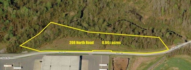
Gordon Ln
415600-115-000-0001-046-000-0000
SARATOGA
Distributionwarehouseregional
New York
C-3
39.002
2025
22.80 AC
2025
Saratoga County
060704
Albany/Schenectady/Troy
10,300 SF
Albany-Schenectady-Troy, NY
NEARBY LISTINGS FOR SALE OR LEASE
DEMOGRAPHICS near Gordon Ln
1 mile
3 mile
5 mile
2025 Total Population
875
8,001
22,474
2030 Population
899
8,112
22,747
Pop Growth 2025-2030
+ 2.74%
+ 1.39%
+ 1.21%
Average Age
43
43
43
2025 Total Households
364
3,104
9,055
HH Growth 2025-2030
+ 2.75%
+ 1.51%
+ 1.14%
Median Household Inc
$99,999
$109,920
$91,131
Avg Household Size
2.40
2.60
2.40
2025 Avg HH Vehicles
2.00
2.00
2.00
Median Home Value
$333,695
$378,817
$354,021
Median Year Built
2003
1997
1998
Nearby Places
Map Layers
Map Styles
 Street
 Aerial
Layers
 Traffic
 Biking
Places
Listings with unknown addresses are not visible on the map
- Restaurants
- Banks
- Shops
- Fitness
- Groceries
PUBLIC TRANSPORTATION
COMMUTER RAIL
Drive
Walk
Distance
15 min
9.2 mi
AIRPORT
Albany International
Drive
Walk
Distance
Albany International
42 min
32.9 mi
Freight Ports
Albany, NY Port
Drive
Walk
Distance
Albany, NY Port
58 min
43.3 mi
SALE & LEASE HISTORY
LISTING DATE
SALE/LEASE

Sep 24, 2016
For Sale
Oct 20, 2020
For Lease
Nov 30, 2020
For Sale
Dec 02, 2019
For Lease
Nearby Properties
Address
Land Use
TOTAL SIZE
Lot Size
Zoning
Address
Land Use
TOTAL SIZE
Lot Size
Zoning
1,506,834 SF
131.26 AC
I-1
Address
Land Use
TOTAL SIZE
Lot Size
Zoning
831,238 SF
129.27 AC
I-1
Address
Land Use
TOTAL SIZE
Lot Size
Zoning
600 SF
298.86 AC
R4
Address
Land Use
TOTAL SIZE
Lot Size
Zoning
399,840 SF
I-1
Address
Land Use
TOTAL SIZE
Lot Size
Zoning
35,619 SF
138.34 AC
PUDD
Address
Land Use
TOTAL SIZE
Lot Size
Zoning
94,496 SF
3.41 AC
C-2
Address
Land Use
TOTAL SIZE
Lot Size
Zoning
980 SF
90.47 AC
R-M
Address
Land Use
TOTAL SIZE
Lot Size
Zoning
6,416 SF
11.77 AC
PUDD
Address
Land Use
TOTAL SIZE
Lot Size
Zoning
53,937 SF
34.35 AC
SD
Address
Land Use
TOTAL SIZE
Lot Size
Zoning
45,160 SF
9.65 AC
C-3
Address
Land Use
TOTAL SIZE
Lot Size
Zoning
480 SF
11.74 AC
R5
Address
Land Use
TOTAL SIZE
Lot Size
Zoning
20,838 SF
2.10 AC
RB-1
Address
Land Use
TOTAL SIZE
Lot Size
Zoning
35,006 SF
26.30 AC
PUDD
Address
Land Use
TOTAL SIZE
Lot Size
Zoning
20,678 SF
8.28 AC
C-3
Address
Land Use
TOTAL SIZE
Lot Size
Zoning
8,940 SF
3 AC
C-3
Address
Land Use
TOTAL SIZE
Lot Size
Zoning
5,000 SF
46.17 AC
NYS
Address
Land Use
TOTAL SIZE
Lot Size
Zoning
1,064 SF
12.27 AC
R-M
Address
Land Use
TOTAL SIZE
Lot Size
Zoning
21,850 SF
19.98 AC
C-2
Address
Land Use
TOTAL SIZE
Lot Size
Zoning
7,560 SF
24.67 AC
TW
Address
Land Use
TOTAL SIZE
Lot Size
Zoning
18,258 SF
5 AC
C-3
Address
Land Use
TOTAL SIZE
Lot Size
Zoning
19,200 SF
4.76 AC
C-2
Address
Land Use
TOTAL SIZE
Lot Size
Zoning
37,720 SF
12.48 AC
C-2
Address
Land Use
TOTAL SIZE
Lot Size
Zoning
6,122 SF
3.22 AC
TW
Address
Land Use
TOTAL SIZE
Lot Size
Zoning
9,180 SF
6.03 AC
C-3
Address
Land Use
TOTAL SIZE
Lot Size
Zoning
9,750 SF
5.04 AC
C-3
Address
Land Use
TOTAL SIZE
Lot Size
Zoning
9,026 SF
2.50 AC
R-2
Address
Land Use
TOTAL SIZE
Lot Size
Zoning
1,800 SF
3.68 AC
C-3
Address
Land Use
TOTAL SIZE
Lot Size
Zoning
11,327 SF
3.03 AC
C-2
Address
Land Use
TOTAL SIZE
Lot Size
Zoning
5,400 SF
3.70 AC
C-3
The World's #1 Commercial Real Estate Marketplace
Connect with us
© 2026 CoStar Group
The information above has been obtained from sources believed reliable. While we do not doubt its accuracy we have not verified it and make no guarantee, warranty or representation about it. It is your responsibility to independently confirm its accuracy and completeness. Any projections, opinions, assumptions, or estimates used are for example only and do not represent the current or future performance of the property. The value of this transaction to you depends on tax and other factors which should be evaluated by your tax, financial, and legal advisors. You and your advisors should conduct a careful, independent investigation of the property to determine to your satisfaction the suitability of the property for your needs.