Property Record
Gorrell Rd, Pilot Point, TX 76258
Save to a Folder
{{folder.Name}}
{{folder.ListingIds.length}} Properties
{{folder.ListingIds.length}} Property
Create a New Folder
Property Detail
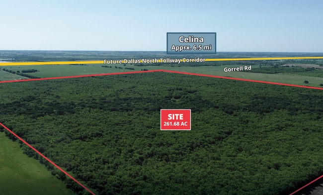
Gorrell Rd
Dallas-Fort Worth-Arlington, TX
A0213A J CURBELLO, TR 15, 146.68 ACRES, OLD DCAD SHT 1, TR 11
R40825
DENTON
Agriculturalland
Texas
A Areas with a 1% annual chance of flooding and a 26% chance of flooding over the life of a 30-year mortgage.
115 AC
2024
Outlying Denton County
2025
Dallas/Ft Worth
020129
NEARBY LISTINGS FOR SALE OR LEASE
-
-
View all Pilot Point listings for sale on LoopNet.com
DEMOGRAPHICS near Gorrell Rd
1 mile
3 mile
5 mile
2025 Total Population
11
443
2,468
2030 Population
14
509
2,923
Pop Growth 2025-2030
+ 27.27%
+ 14.90%
+ 18.44%
Average Age
32
38
37
2025 Total Households
4
154
778
HH Growth 2025-2030
0.00%
+ 14.29%
+ 17.99%
Median Household Inc
$175,000
$102,344
$128,167
Avg Household Size
3.00
2.90
3.10
2025 Avg HH Vehicles
2.00
2.00
2.00
Median Home Value
$750,000
$391,176
$544,613
Median Year Built
2011
2007
2010
Nearby Places
Map Layers
Map Styles
 Street
 Aerial
Layers
 Traffic
 Biking
Places
Listings with unknown addresses are not visible on the map
- Restaurants
- Banks
- Shops
- Fitness
- Groceries
SALE & LEASE HISTORY
LISTING DATE
SALE/LEASE

Jun 06, 2022
For Sale
Nearby Properties
Address
Land Use
TOTAL SIZE
Lot Size
Zoning
Address
Land Use
TOTAL SIZE
Lot Size
Zoning
417.34 AC
Address
Land Use
TOTAL SIZE
Lot Size
Zoning
13.75 AC
COMM
Address
Land Use
TOTAL SIZE
Lot Size
Zoning
118.80 AC
Address
Land Use
TOTAL SIZE
Lot Size
Zoning
8,146 SF
4.75 AC
Address
Land Use
TOTAL SIZE
Lot Size
Zoning
6,400 SF
12.10 AC
Address
Land Use
TOTAL SIZE
Lot Size
Zoning
14.03 AC
AG
Address
Land Use
TOTAL SIZE
Lot Size
Zoning
6,265 SF
21.69 AC
Address
Land Use
TOTAL SIZE
Lot Size
Zoning
11,940 SF
4.72 AC
Address
Land Use
TOTAL SIZE
Lot Size
Zoning
2,860 SF
156.38 AC
Address
Land Use
TOTAL SIZE
Lot Size
Zoning
13.80 AC
Address
Land Use
TOTAL SIZE
Lot Size
Zoning
2,016 SF
6.16 AC
Address
Land Use
TOTAL SIZE
Lot Size
Zoning
2,304 SF
2.50 AC
Address
Land Use
TOTAL SIZE
Lot Size
Zoning
2.27 AC
AG
Address
Land Use
TOTAL SIZE
Lot Size
Zoning
6,004 SF
33.72 AC
Address
Land Use
TOTAL SIZE
Lot Size
Zoning
2.20 AC
Address
Land Use
TOTAL SIZE
Lot Size
Zoning
4,223 SF
8.39 AC
Address
Land Use
TOTAL SIZE
Lot Size
Zoning
3,560 SF
15 AC
Address
Land Use
TOTAL SIZE
Lot Size
Zoning
15.26 AC
Address
Land Use
TOTAL SIZE
Lot Size
Zoning
3,456 SF
16.94 AC
Address
Land Use
TOTAL SIZE
Lot Size
Zoning
13.50 AC
Address
Land Use
TOTAL SIZE
Lot Size
Zoning
10,200 SF
5 AC
Address
Land Use
TOTAL SIZE
Lot Size
Zoning
3,537 SF
16.28 AC
Address
Land Use
TOTAL SIZE
Lot Size
Zoning
2,100 SF
15.43 AC
Address
Land Use
TOTAL SIZE
Lot Size
Zoning
4,643 SF
13.11 AC
Address
Land Use
TOTAL SIZE
Lot Size
Zoning
4,297 SF
2.06 AC
Address
Land Use
TOTAL SIZE
Lot Size
Zoning
2,016 SF
3.55 AC
Address
Land Use
TOTAL SIZE
Lot Size
Zoning
5,000 SF
8.04 AC
The World's #1 Commercial Real Estate Marketplace
Connect with us
© 2026 CoStar Group
The information above has been obtained from sources believed reliable. While we do not doubt its accuracy we have not verified it and make no guarantee, warranty or representation about it. It is your responsibility to independently confirm its accuracy and completeness. Any projections, opinions, assumptions, or estimates used are for example only and do not represent the current or future performance of the property. The value of this transaction to you depends on tax and other factors which should be evaluated by your tax, financial, and legal advisors. You and your advisors should conduct a careful, independent investigation of the property to determine to your satisfaction the suitability of the property for your needs.