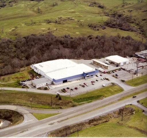
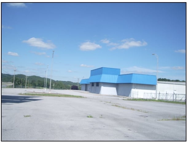
Property Record
Gov G C Peery Hwy, Bluefield, VA 24605

NEARBY LISTINGS FOR SALE OR LEASE
-
-
View all Bluefield listings for sale on LoopNet.com
Property Detail
Gov G C Peery Hwy
040-A-0033
St Clair Heights
Warehouse
12.17 ACRES BLUESTONE ON S SIDE OF 19-460
AE
Tazewell
51185C0230D
Virginia
2025
12.17 AC
2025
Virginia Regional
020200
Other Market Areas
64,500 SF
Bluefield, WV-VA
DEMOGRAPHICS near Gov G C Peery Hwy
1 Mile
3 Mile
5 Mile
2024 Total Population
195
5,530
12,159
2029 Population
194
5,493
12,074
Pop Growth 2024-2029
(0.51%)
(0.67%)
(0.70%)
Average Age
45
44
43
2024 Total Households
84
2,317
4,826
HH Growth 2024-2029
(1.19%)
(0.65%)
(0.68%)
Median Household Inc
$61,667
$55,689
$44,072
Avg Household Size
2.20
2.30
2.30
2024 Avg HH Vehicles
2.00
2.00
2.00
Median Home Value
$174,999
$154,025
$125,841
Median Year Built
1970
1963
1965
Nearby Places
Map Layers
Map Styles
 Street
 Aerial
- Restaurants
- Banks
- Shops
- Fitness
- Groceries
Nearby Properties
Address
Land Use
TOTAL SIZE
Lot Size
Zoning
Address
Land Use
TOTAL SIZE
Lot Size
Zoning
78,973 SF
23 AC
Address
Land Use
TOTAL SIZE
Lot Size
Zoning
1,232 SF
12.38 AC
Address
Land Use
TOTAL SIZE
Lot Size
Zoning
15,395 SF
14.61 AC
Address
Land Use
TOTAL SIZE
Lot Size
Zoning
11,697 SF
1.68 AC
Address
Land Use
TOTAL SIZE
Lot Size
Zoning
34,764 SF
3.77 AC
Address
Land Use
TOTAL SIZE
Lot Size
Zoning
30,246 SF
5.50 AC
Address
Land Use
TOTAL SIZE
Lot Size
Zoning
6,483 SF
13.64 AC
Address
Land Use
TOTAL SIZE
Lot Size
Zoning
27,880 SF
3 AC
Address
Land Use
TOTAL SIZE
Lot Size
Zoning
92,106 SF
6.73 AC
Address
Land Use
TOTAL SIZE
Lot Size
Zoning
7,200 SF
4.64 AC
Address
Land Use
TOTAL SIZE
Lot Size
Zoning
17,455 SF
2 AC
Address
Land Use
TOTAL SIZE
Lot Size
Zoning
82,440 SF
8.64 AC
Address
Land Use
TOTAL SIZE
Lot Size
Zoning
5,415 SF
5 AC
Address
Land Use
TOTAL SIZE
Lot Size
Zoning
8.83 AC
Address
Land Use
TOTAL SIZE
Lot Size
Zoning
7,158 SF
3.86 AC
Address
Land Use
TOTAL SIZE
Lot Size
Zoning
21,912 SF
4.08 AC
Address
Land Use
TOTAL SIZE
Lot Size
Zoning
24,000 SF
2 AC
Address
Land Use
TOTAL SIZE
Lot Size
Zoning
38,182 SF
2.53 AC
Address
Land Use
TOTAL SIZE
Lot Size
Zoning
9,870 SF
1.99 AC
Address
Land Use
TOTAL SIZE
Lot Size
Zoning
13,700 SF
6 AC
Address
Land Use
TOTAL SIZE
Lot Size
Zoning
11,424 SF
0.63 AC
Address
Land Use
TOTAL SIZE
Lot Size
Zoning
97,426 SF
10.53 AC
Address
Land Use
TOTAL SIZE
Lot Size
Zoning
7,988 SF
4.52 AC
Address
Land Use
TOTAL SIZE
Lot Size
Zoning
3,584 SF
1.60 AC
Address
Land Use
TOTAL SIZE
Lot Size
Zoning
2,402 SF
39.71 AC
Address
Land Use
TOTAL SIZE
Lot Size
Zoning
4,800 SF
2.72 AC
Address
Land Use
TOTAL SIZE
Lot Size
Zoning
7,848 SF
2.33 AC
Address
Land Use
TOTAL SIZE
Lot Size
Zoning
64,500 SF
12.17 AC
Address
Land Use
TOTAL SIZE
Lot Size
Zoning
11,046 SF
2.11 AC
Address
Land Use
TOTAL SIZE
Lot Size
Zoning
80,000 SF
4.62 AC
The World's #1 Commercial Real Estate Marketplace
Connect with us
© 2026 CoStar Group
The information above has been obtained from sources believed reliable. While we do not doubt its accuracy we have not verified it and make no guarantee, warranty or representation about it. It is your responsibility to independently confirm its accuracy and completeness. Any projections, opinions, assumptions, or estimates used are for example only and do not represent the current or future performance of the property. The value of this transaction to you depends on tax and other factors which should be evaluated by your tax, financial, and legal advisors. You and your advisors should conduct a careful, independent investigation of the property to determine to your satisfaction the suitability of the property for your needs.