Property Record
Grambling Ct, East Saint Louis, IL 62207


NEARBY LISTINGS FOR SALE OR LEASE
-
-
View all East Saint Louis listings for sale on LoopNet.com
Property Detail
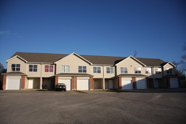
Grambling Ct
St. Louis
Caya Tract
St. Louis, MO-IL
CAYA TRACT LOT/SEC-7 PT LOT 7 & LT 23 OF EAST WESTON PL IN BK 3293-2380
07-04.0-302-045
St. Clair
Apartment
Illinois
2024
7,23
2024
13.10 AC
503416
East Saint Louis
4,638 SF
DEMOGRAPHICS near Grambling Ct
1 Mile
3 Mile
5 Mile
2024 Total Population
2,846
19,599
68,566
2029 Population
2,848
19,673
68,877
Pop Growth 2024-2029
+ 0.07%
+ 0.38%
+ 0.45%
Average Age
38
41
41
2024 Total Households
1,153
7,838
27,895
HH Growth 2024-2029
+ 0.17%
+ 0.37%
+ 0.41%
Median Household Inc
$28,749
$44,980
$44,149
Avg Household Size
2.40
2.40
2.40
2024 Avg HH Vehicles
1.00
2.00
1.00
Median Home Value
$88,849
$92,470
$83,484
Median Year Built
1986
1969
1965
Nearby Places
Map Layers
Map Styles
 Street
 Aerial
- Restaurants
- Banks
- Shops
- Fitness
- Groceries
PUBLIC TRANSPORTATION
COMMUTER RAIL
Fairview Heights (Lambert Airport Shiloh-Scott - St. Louis MetroLink (MetroLink), Shrewsbury-Lansdowne I-44 Emerson Park - St. Louis MetroLink (MetroLink))
DRIVE
WALK
Distance
Fairview Heights (Lambert Airport Shiloh-Scott - St. Louis MetroLink (MetroLink), Shrewsbury-Lansdowne I-44 Emerson Park - St. Louis MetroLink (MetroLink))
11 min
5.5 mi
Jackie Joyner-Kersee (Lambert Airport Shiloh-Scott - St. Louis MetroLink (MetroLink), Shrewsbury-Lansdowne I-44 Emerson Park - St. Louis MetroLink (MetroLink))
DRIVE
WALK
Distance
Jackie Joyner-Kersee (Lambert Airport Shiloh-Scott - St. Louis MetroLink (MetroLink), Shrewsbury-Lansdowne I-44 Emerson Park - St. Louis MetroLink (MetroLink))
12 min
5.7 mi
AIRPORT
Scott AFB/Midamerica St Louis
DRIVE
WALK
Distance
Scott AFB/Midamerica St Louis
36 min
20.2 mi
St Louis Lambert International
DRIVE
WALK
Distance
St Louis Lambert International
35 min
21.6 mi
Nearby Properties
Address
Land Use
TOTAL SIZE
Lot Size
Zoning
Address
Land Use
TOTAL SIZE
Lot Size
Zoning
28.07 AC
Address
Land Use
TOTAL SIZE
Lot Size
Zoning
147,888 SF
52.30 AC
Address
Land Use
TOTAL SIZE
Lot Size
Zoning
82,500 SF
14.61 AC
Address
Land Use
TOTAL SIZE
Lot Size
Zoning
118,030 SF
6.78 AC
Address
Land Use
TOTAL SIZE
Lot Size
Zoning
80,000 SF
71.47 AC
Address
Land Use
TOTAL SIZE
Lot Size
Zoning
16,958 SF
24.53 AC
Address
Land Use
TOTAL SIZE
Lot Size
Zoning
18.43 AC
Address
Land Use
TOTAL SIZE
Lot Size
Zoning
26.26 AC
C2
Address
Land Use
TOTAL SIZE
Lot Size
Zoning
8,745 SF
14.55 AC
Address
Land Use
TOTAL SIZE
Lot Size
Zoning
18,837 SF
134.15 AC
Address
Land Use
TOTAL SIZE
Lot Size
Zoning
61,580 SF
16.32 AC
Address
Land Use
TOTAL SIZE
Lot Size
Zoning
Address
Land Use
TOTAL SIZE
Lot Size
Zoning
51,739 SF
1.99 AC
Address
Land Use
TOTAL SIZE
Lot Size
Zoning
16,637 SF
4.59 AC
Address
Land Use
TOTAL SIZE
Lot Size
Zoning
5,512 SF
10.36 AC
Address
Land Use
TOTAL SIZE
Lot Size
Zoning
19.66 AC
Address
Land Use
TOTAL SIZE
Lot Size
Zoning
14.70 AC
Address
Land Use
TOTAL SIZE
Lot Size
Zoning
20,924 SF
6.16 AC
Address
Land Use
TOTAL SIZE
Lot Size
Zoning
71,600 SF
32.19 AC
Address
Land Use
TOTAL SIZE
Lot Size
Zoning
76,958 SF
9.49 AC
Address
Land Use
TOTAL SIZE
Lot Size
Zoning
4,950 SF
3.87 AC
Address
Land Use
TOTAL SIZE
Lot Size
Zoning
23,819 SF
7.64 AC
Address
Land Use
TOTAL SIZE
Lot Size
Zoning
10,182 SF
2.42 AC
Address
Land Use
TOTAL SIZE
Lot Size
Zoning
24,120 SF
3.81 AC
Address
Land Use
TOTAL SIZE
Lot Size
Zoning
Address
Land Use
TOTAL SIZE
Lot Size
Zoning
Address
Land Use
TOTAL SIZE
Lot Size
Zoning
7,000 SF
4.67 AC
Address
Land Use
TOTAL SIZE
Lot Size
Zoning
Address
Land Use
TOTAL SIZE
Lot Size
Zoning
21,000 SF
2.73 AC
The World's #1 Commercial Real Estate Marketplace
Connect with us
© 2026 CoStar Group
The information above has been obtained from sources believed reliable. While we do not doubt its accuracy we have not verified it and make no guarantee, warranty or representation about it. It is your responsibility to independently confirm its accuracy and completeness. Any projections, opinions, assumptions, or estimates used are for example only and do not represent the current or future performance of the property. The value of this transaction to you depends on tax and other factors which should be evaluated by your tax, financial, and legal advisors. You and your advisors should conduct a careful, independent investigation of the property to determine to your satisfaction the suitability of the property for your needs.