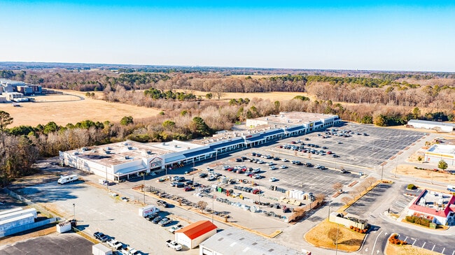
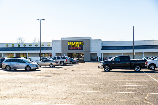
Property Record
Grantham St, Goldsboro, NC 27530
NEARBY LISTINGS FOR SALE OR LEASE
Property Detail
Grantham St
Goldsboro, NC
Stone Goldsboro Limited Partnership
2690228003
Wayne
Stripcommercialcenter
North Carolina
AE
15.27 AC
3720268000K
North Carolina Southeast Area
120,515 SF
Other Market Areas
DEMOGRAPHICS near Grantham St
1 Mile
3 Mile
5 Mile
2024 Total Population
1,218
19,054
45,390
2029 Population
1,237
19,438
45,624
Pop Growth 2024-2029
+ 1.56%
+ 2.02%
+ 0.52%
Average Age
41
41
40
2024 Total Households
362
7,638
18,278
HH Growth 2024-2029
+ 2.49%
+ 2.23%
+ 0.62%
Median Household Inc
$23,899
$33,503
$42,445
Avg Household Size
2.40
2.20
2.30
2024 Avg HH Vehicles
1.00
1.00
2.00
Median Home Value
$127,778
$156,221
$174,476
Median Year Built
1973
1968
1977
Nearby Places
Map Layers
Map Styles
 Street
 Aerial
- Restaurants
- Banks
- Shops
- Fitness
- Groceries
SALE & LEASE HISTORY
LISTING DATE
SALE/LEASE

Sep 25, 2016
For Lease
Sep 12, 2024
For Sale
Oct 14, 2019
For Sale
Mar 03, 2021
For Sale
Jul 02, 2021
For Lease
Jan 24, 2024
For Sale
Jan 07, 2025
For Sale
Apr 08, 2022
For Sale
Nearby Properties
Address
Land Use
TOTAL SIZE
Lot Size
Zoning
Address
Land Use
TOTAL SIZE
Lot Size
Zoning
1,577.01 AC
Address
Land Use
TOTAL SIZE
Lot Size
Zoning
410,361 SF
186.26 AC
O&I
Address
Land Use
TOTAL SIZE
Lot Size
Zoning
32,568 SF
2.90 AC
CBDH
Address
Land Use
TOTAL SIZE
Lot Size
Zoning
8,960 SF
13.22 AC
O&I
Address
Land Use
TOTAL SIZE
Lot Size
Zoning
113,842 SF
13.59 AC
Address
Land Use
TOTAL SIZE
Lot Size
Zoning
8,100 SF
8.60 AC
Address
Land Use
TOTAL SIZE
Lot Size
Zoning
49,557 SF
15 AC
Address
Land Use
TOTAL SIZE
Lot Size
Zoning
7,188 SF
10 AC
R-6
Address
Land Use
TOTAL SIZE
Lot Size
Zoning
168,800 SF
22.70 AC
I-5
Address
Land Use
TOTAL SIZE
Lot Size
Zoning
48,500 SF
0.12 AC
CBDH
Address
Land Use
TOTAL SIZE
Lot Size
Zoning
51,688 SF
7.58 AC
GB
Address
Land Use
TOTAL SIZE
Lot Size
Zoning
8,160 SF
38.75 AC
Address
Land Use
TOTAL SIZE
Lot Size
Zoning
10,000 SF
20.22 AC
Address
Land Use
TOTAL SIZE
Lot Size
Zoning
54,407 SF
4 AC
I 5
Address
Land Use
TOTAL SIZE
Lot Size
Zoning
32,674 SF
7.97 AC
Address
Land Use
TOTAL SIZE
Lot Size
Zoning
7,912 SF
54.13 AC
I-2
Address
Land Use
TOTAL SIZE
Lot Size
Zoning
66,494 SF
4.15 AC
Address
Land Use
TOTAL SIZE
Lot Size
Zoning
65,966 SF
7.92 AC
GB
Address
Land Use
TOTAL SIZE
Lot Size
Zoning
6,860 SF
9.97 AC
R-6
Address
Land Use
TOTAL SIZE
Lot Size
Zoning
38,152 SF
4 AC
O&I
Address
Land Use
TOTAL SIZE
Lot Size
Zoning
33,488 SF
2.89 AC
Address
Land Use
TOTAL SIZE
Lot Size
Zoning
74,072 SF
1.04 AC
CBDH
Address
Land Use
TOTAL SIZE
Lot Size
Zoning
25,692 SF
7.31 AC
HB
Address
Land Use
TOTAL SIZE
Lot Size
Zoning
112,616 SF
12.02 AC
I-5
Address
Land Use
TOTAL SIZE
Lot Size
Zoning
28,153 SF
5.99 AC
Address
Land Use
TOTAL SIZE
Lot Size
Zoning
64,964 SF
20 AC
O&I
Address
Land Use
TOTAL SIZE
Lot Size
Zoning
25,810 SF
215.91 AC
Address
Land Use
TOTAL SIZE
Lot Size
Zoning
5,640 SF
49.11 AC
OH
Address
Land Use
TOTAL SIZE
Lot Size
Zoning
2,072 SF
1.67 AC
I-5
Address
Land Use
TOTAL SIZE
Lot Size
Zoning
70,666 SF
7.42 AC
The World's #1 Commercial Real Estate Marketplace
Connect with us
© 2025 CoStar Group
The information above has been obtained from sources believed reliable. While we do not doubt its accuracy we have not verified it and make no guarantee, warranty or representation about it. It is your responsibility to independently confirm its accuracy and completeness. Any projections, opinions, assumptions, or estimates used are for example only and do not represent the current or future performance of the property. The value of this transaction to you depends on tax and other factors which should be evaluated by your tax, financial, and legal advisors. You and your advisors should conduct a careful, independent investigation of the property to determine to your satisfaction the suitability of the property for your needs.