Property Record
634 Grassfield Pkwy, Chesapeake, VA 23322
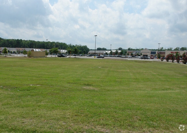

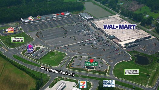
Property Detail
634 Grassfield Pkwy
0460000001650
PARCEL B4 SUBD DOMINION COMMONS 1.382
Commercialacreage
CHESAPEAKE
B2: GENERA
Virginia
C and X Area of minimal flood hazard, usually depicted on FIRMs as above the 500-year flood level.
1.38 AC
2024
Southern Chesapeake
2025
Hampton Roads
021014
Virginia Beach-Chesapeake-Norfolk, VA-NC
NEARBY LISTINGS FOR SALE OR LEASE
DEMOGRAPHICS near 634 Grassfield Pkwy
1 mile
3 mile
5 mile
2025 Total Population
5,342
47,023
111,438
2030 Population
5,439
47,790
113,038
Pop Growth 2025-2030
+ 1.82%
+ 1.63%
+ 1.44%
Average Age
41
38
39
2025 Total Households
1,908
16,084
40,470
HH Growth 2025-2030
+ 1.78%
+ 1.68%
+ 1.47%
Median Household Inc
$141,719
$129,513
$100,780
Avg Household Size
2.80
2.90
2.70
2025 Avg HH Vehicles
2.00
2.00
2.00
Median Home Value
$463,339
$437,955
$393,655
Median Year Built
2002
1995
1991
Nearby Places
Map Layers
Map Styles
 Street
 Aerial
Transit
 Traffic
 Biking
Places
Listings with unknown addresses are not visible on the map
- Restaurants
- Banks
- Shops
- Fitness
- Groceries
PUBLIC TRANSPORTATION
AIRPORT
Norfolk International
Drive
Walk
Distance
Norfolk International
26 min
17.1 mi
Freight Ports
Virginia Port Authority - Portsmouth
Drive
Walk
Distance
Virginia Port Authority - Portsmouth
25 min
14.7 mi
SALE & LEASE HISTORY
LISTING DATE
SALE/LEASE

Sep 25, 2016
For Lease
Sep 24, 2016
For Sale
Jun 10, 2020
For Sale
Jul 05, 2017
For Lease
Aug 15, 2018
For Sale
Nearby Properties
Address
Land Use
TOTAL SIZE
Lot Size
Zoning
Address
Land Use
TOTAL SIZE
Lot Size
Zoning
6,820 SF
89.90 AC
R15S: RESI
Address
Land Use
TOTAL SIZE
Lot Size
Zoning
141,461 SF
169.22 AC
C1: CONSER
Address
Land Use
TOTAL SIZE
Lot Size
Zoning
338,400 SF
96.79 AC
A1: AGRICU
Address
Land Use
TOTAL SIZE
Lot Size
Zoning
26.78 AC
RMF1: MULT
Address
Land Use
TOTAL SIZE
Lot Size
Zoning
195,637 SF
96.05 AC
RE1: RESID
Address
Land Use
TOTAL SIZE
Lot Size
Zoning
63,050 SF
27.71 AC
O-I: OFFIC
Address
Land Use
TOTAL SIZE
Lot Size
Zoning
107,223 SF
48.07 AC
O-I: OFFIC
Address
Land Use
TOTAL SIZE
Lot Size
Zoning
67,508 SF
16.63 AC
O-I: OFFIC
Address
Land Use
TOTAL SIZE
Lot Size
Zoning
148,905 SF
7.32 AC
PUD: PLANN
Address
Land Use
TOTAL SIZE
Lot Size
Zoning
213,740 SF
26.51 AC
B2: GENERA
Address
Land Use
TOTAL SIZE
Lot Size
Zoning
91,968 SF
6.33 AC
O-I: OFFIC
Address
Land Use
TOTAL SIZE
Lot Size
Zoning
38,354 SF
2.23 AC
PUD: PLANN
Address
Land Use
TOTAL SIZE
Lot Size
Zoning
103,693 SF
5.83 AC
O-I: OFFIC
Address
Land Use
TOTAL SIZE
Lot Size
Zoning
4,300 SF
11.21 AC
PUD: PLANN
Address
Land Use
TOTAL SIZE
Lot Size
Zoning
53,454 SF
8.43 AC
B4: SHOPPI
Address
Land Use
TOTAL SIZE
Lot Size
Zoning
104,312 SF
8.06 AC
RMF1: MULT
Address
Land Use
TOTAL SIZE
Lot Size
Zoning
210,964 SF
55.68 AC
M1: LIGHT
Address
Land Use
TOTAL SIZE
Lot Size
Zoning
59,712 SF
8.33 AC
O-I: OFFIC
Address
Land Use
TOTAL SIZE
Lot Size
Zoning
48,360 SF
14.75 AC
M3: WATERF
Address
Land Use
TOTAL SIZE
Lot Size
Zoning
65,088 SF
20.50 AC
R10S: RESI
Address
Land Use
TOTAL SIZE
Lot Size
Zoning
82,416 SF
14.11 AC
RMF1: MULT
Address
Land Use
TOTAL SIZE
Lot Size
Zoning
43,800 SF
2.50 AC
PUD: PLANN
Address
Land Use
TOTAL SIZE
Lot Size
Zoning
63,350 SF
9.69 AC
B1: NEIGHB
Address
Land Use
TOTAL SIZE
Lot Size
Zoning
140,699 SF
54.80 AC
M2: GENERA
Address
Land Use
TOTAL SIZE
Lot Size
Zoning
42,174 SF
5.28 AC
PUD: PLANN
Address
Land Use
TOTAL SIZE
Lot Size
Zoning
42,050 SF
7.37 AC
M3: WATERF
Address
Land Use
TOTAL SIZE
Lot Size
Zoning
134,609 SF
13.32 AC
M3: WATERF
Address
Land Use
TOTAL SIZE
Lot Size
Zoning
41,092 SF
5.96 AC
B1: NEIGHB
Address
Land Use
TOTAL SIZE
Lot Size
Zoning
71,438 SF
20.14 AC
B2: GENERA
Address
Land Use
TOTAL SIZE
Lot Size
Zoning
40,274 SF
3 AC
PUD: PLANN
The World's #1 Commercial Real Estate Marketplace
Connect with us
© 2026 CoStar Group
The information above has been obtained from sources believed reliable. While we do not doubt its accuracy we have not verified it and make no guarantee, warranty or representation about it. It is your responsibility to independently confirm its accuracy and completeness. Any projections, opinions, assumptions, or estimates used are for example only and do not represent the current or future performance of the property. The value of this transaction to you depends on tax and other factors which should be evaluated by your tax, financial, and legal advisors. You and your advisors should conduct a careful, independent investigation of the property to determine to your satisfaction the suitability of the property for your needs.