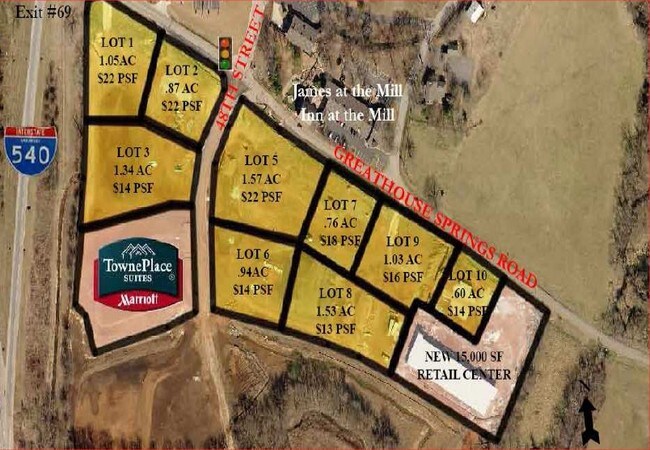
Property Record
48Th St, Johnson, AR 72741
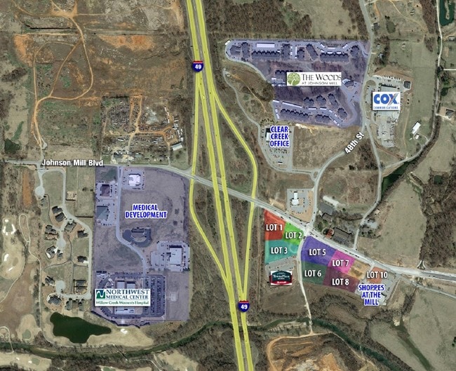
NEARBY LISTINGS FOR SALE OR LEASE
-
-
-
-
-
-
-
-
-
No Photo
-
-
-
-
-
-
-
-
-
-
View all Johnson listings for sale on LoopNet.com
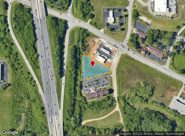
Property Detail
48Th St
Fayetteville-Springdale-Rogers, AR-MO
Maverick Commercial Park
785-19308-000
LOT 3R PER REPLAT LOTS 1-3 MAVERICK COMMERCIAL PARK 24A-463 1.11 AC
Commercialacreage
Washington
AE
Arkansas
05143C0070G
1-3
2025
1.11 AC
2025
Greater Springdale
010511
Fayetteville/Springdale/Rogers
DEMOGRAPHICS near 48Th St
1 Mile
3 Mile
5 Mile
2024 Total Population
2,513
32,741
137,257
2029 Population
2,760
35,721
150,154
Pop Growth 2024-2029
+ 9.83%
+ 9.10%
+ 9.40%
Average Age
39
37
35
2024 Total Households
1,017
14,132
53,111
HH Growth 2024-2029
+ 9.83%
+ 9.39%
+ 9.72%
Median Household Inc
$91,810
$62,628
$65,320
Avg Household Size
2.50
2.30
2.40
2024 Avg HH Vehicles
2.00
2.00
2.00
Median Home Value
$387,640
$252,284
$250,191
Median Year Built
2002
1996
1994
Nearby Places
Map Layers
Map Styles
 Street
 Aerial
- Restaurants
- Banks
- Shops
- Fitness
- Groceries
PUBLIC TRANSPORTATION
AIRPORT
Northwest Arkansas Ntl
DRIVE
WALK
Distance
Northwest Arkansas Ntl
31 min
15.3 mi
SALE & LEASE HISTORY
LISTING DATE
SALE/LEASE

Sep 25, 2016
For Lease
Sep 24, 2016
For Sale
Aug 21, 2017
For Sale
Nearby Properties
Address
Land Use
TOTAL SIZE
Lot Size
Zoning
Address
Land Use
TOTAL SIZE
Lot Size
Zoning
132,060 SF
8 AC
Address
Land Use
TOTAL SIZE
Lot Size
Zoning
167,116 SF
41.39 AC
I1
Address
Land Use
TOTAL SIZE
Lot Size
Zoning
153,698 SF
14.10 AC
C2
Address
Land Use
TOTAL SIZE
Lot Size
Zoning
181,734 SF
21.02 AC
Address
Land Use
TOTAL SIZE
Lot Size
Zoning
23,707 SF
15.45 AC
R2
Address
Land Use
TOTAL SIZE
Lot Size
Zoning
15,347 SF
6.27 AC
Address
Land Use
TOTAL SIZE
Lot Size
Zoning
238,168 SF
Address
Land Use
TOTAL SIZE
Lot Size
Zoning
437,349 SF
40.29 AC
Address
Land Use
TOTAL SIZE
Lot Size
Zoning
106,141 SF
2.82 AC
Address
Land Use
TOTAL SIZE
Lot Size
Zoning
50,708 SF
1.69 AC
C2
Address
Land Use
TOTAL SIZE
Lot Size
Zoning
232,212 SF
10.31 AC
Address
Land Use
TOTAL SIZE
Lot Size
Zoning
305,272 SF
9.66 AC
R2
Address
Land Use
TOTAL SIZE
Lot Size
Zoning
121,758 SF
20.54 AC
Address
Land Use
TOTAL SIZE
Lot Size
Zoning
81,000 SF
7.01 AC
Address
Land Use
TOTAL SIZE
Lot Size
Zoning
78,374 SF
8.79 AC
Address
Land Use
TOTAL SIZE
Lot Size
Zoning
567,022 SF
88.88 AC
C2
Address
Land Use
TOTAL SIZE
Lot Size
Zoning
6,798 SF
10.56 AC
Address
Land Use
TOTAL SIZE
Lot Size
Zoning
19,805 SF
0.35 AC
R0
Address
Land Use
TOTAL SIZE
Lot Size
Zoning
106,961 SF
8.56 AC
Address
Land Use
TOTAL SIZE
Lot Size
Zoning
178,014 SF
6.43 AC
Address
Land Use
TOTAL SIZE
Lot Size
Zoning
117,690 SF
2.38 AC
Address
Land Use
TOTAL SIZE
Lot Size
Zoning
261,670 SF
16.72 AC
R2
Address
Land Use
TOTAL SIZE
Lot Size
Zoning
176,204 SF
7.57 AC
Address
Land Use
TOTAL SIZE
Lot Size
Zoning
217,873 SF
24.10 AC
C2
Address
Land Use
TOTAL SIZE
Lot Size
Zoning
193,140 SF
21.31 AC
Address
Land Use
TOTAL SIZE
Lot Size
Zoning
64,824 SF
15.82 AC
C2
Address
Land Use
TOTAL SIZE
Lot Size
Zoning
116,702 SF
17.77 AC
R2
Address
Land Use
TOTAL SIZE
Lot Size
Zoning
134,342 SF
14.95 AC
Address
Land Use
TOTAL SIZE
Lot Size
Zoning
59,460 SF
7 AC
Address
Land Use
TOTAL SIZE
Lot Size
Zoning
56,672 SF
0.53 AC
R0
The World's #1 Commercial Real Estate Marketplace
Connect with us
© 2025 CoStar Group
The information above has been obtained from sources believed reliable. While we do not doubt its accuracy we have not verified it and make no guarantee, warranty or representation about it. It is your responsibility to independently confirm its accuracy and completeness. Any projections, opinions, assumptions, or estimates used are for example only and do not represent the current or future performance of the property. The value of this transaction to you depends on tax and other factors which should be evaluated by your tax, financial, and legal advisors. You and your advisors should conduct a careful, independent investigation of the property to determine to your satisfaction the suitability of the property for your needs.