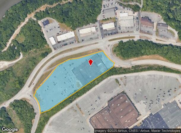
Property Record
Greenbag Rd, Morgantown, WV 26501
NEARBY LISTINGS FOR SALE OR LEASE
Property Detail
Greenbag Rd
09-48A-00020001
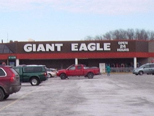
5.856 AC SUR & R/W (GIANT EAGLE)
Supermarket
Monongalia
X
West Virginia
54061C0227F
5.86 AC
2025
West Virginia North Area
2025
Other Market Areas
011100
Morgantown, WV
DEMOGRAPHICS near Greenbag Rd
1 Mile
3 Mile
5 Mile
2024 Total Population
4,027
42,389
77,922
2029 Population
4,120
43,598
79,893
Pop Growth 2024-2029
+ 2.31%
+ 2.85%
+ 2.53%
Average Age
41
34
35
2024 Total Households
1,704
17,276
33,176
HH Growth 2024-2029
+ 2.35%
+ 3.02%
+ 2.62%
Median Household Inc
$51,768
$38,761
$51,175
Avg Household Size
2.10
2.00
2.10
2024 Avg HH Vehicles
2.00
1.00
2.00
Median Home Value
$192,367
$199,611
$231,672
Median Year Built
1962
1974
1984
Nearby Places
Map Layers
Map Styles
 Street
 Aerial
- Restaurants
- Banks
- Shops
- Fitness
- Groceries
PUBLIC TRANSPORTATION
AIRPORT
North Central West Virginia
DRIVE
WALK
Distance
North Central West Virginia
38 min
31.0 mi
Freight Ports
Port of Baltimore
DRIVE
WALK
Distance
Port of Baltimore
243 min
215.4 mi
Nearby Properties
Address
Land Use
TOTAL SIZE
Lot Size
Zoning
Address
Land Use
TOTAL SIZE
Lot Size
Zoning
5.15 AC
Address
Land Use
TOTAL SIZE
Lot Size
Zoning
14.68 AC
Address
Land Use
TOTAL SIZE
Lot Size
Zoning
137.68 AC
Address
Land Use
TOTAL SIZE
Lot Size
Zoning
3.07 AC
Address
Land Use
TOTAL SIZE
Lot Size
Zoning
35.17 AC
Address
Land Use
TOTAL SIZE
Lot Size
Zoning
7.10 AC
Address
Land Use
TOTAL SIZE
Lot Size
Zoning
15.71 AC
Address
Land Use
TOTAL SIZE
Lot Size
Zoning
53.50 AC
Address
Land Use
TOTAL SIZE
Lot Size
Zoning
Address
Land Use
TOTAL SIZE
Lot Size
Zoning
Address
Land Use
TOTAL SIZE
Lot Size
Zoning
9.63 AC
Address
Land Use
TOTAL SIZE
Lot Size
Zoning
34.21 AC
Address
Land Use
TOTAL SIZE
Lot Size
Zoning
154.89 AC
Address
Land Use
TOTAL SIZE
Lot Size
Zoning
0.23 AC
Address
Land Use
TOTAL SIZE
Lot Size
Zoning
Address
Land Use
TOTAL SIZE
Lot Size
Zoning
22.71 AC
Address
Land Use
TOTAL SIZE
Lot Size
Zoning
75.11 AC
Address
Land Use
TOTAL SIZE
Lot Size
Zoning
Address
Land Use
TOTAL SIZE
Lot Size
Zoning
9.94 AC
Address
Land Use
TOTAL SIZE
Lot Size
Zoning
0.11 AC
Address
Land Use
TOTAL SIZE
Lot Size
Zoning
15.03 AC
Address
Land Use
TOTAL SIZE
Lot Size
Zoning
14.08 AC
Address
Land Use
TOTAL SIZE
Lot Size
Zoning
3.20 AC
Address
Land Use
TOTAL SIZE
Lot Size
Zoning
0.18 AC
Address
Land Use
TOTAL SIZE
Lot Size
Zoning
75.37 AC
Address
Land Use
TOTAL SIZE
Lot Size
Zoning
5.20 AC
Address
Land Use
TOTAL SIZE
Lot Size
Zoning
1.20 AC
Address
Land Use
TOTAL SIZE
Lot Size
Zoning
0.19 AC
Address
Land Use
TOTAL SIZE
Lot Size
Zoning
2,983 SF
53.98 AC
The World's #1 Commercial Real Estate Marketplace
Connect with us
© 2026 CoStar Group
The information above has been obtained from sources believed reliable. While we do not doubt its accuracy we have not verified it and make no guarantee, warranty or representation about it. It is your responsibility to independently confirm its accuracy and completeness. Any projections, opinions, assumptions, or estimates used are for example only and do not represent the current or future performance of the property. The value of this transaction to you depends on tax and other factors which should be evaluated by your tax, financial, and legal advisors. You and your advisors should conduct a careful, independent investigation of the property to determine to your satisfaction the suitability of the property for your needs.