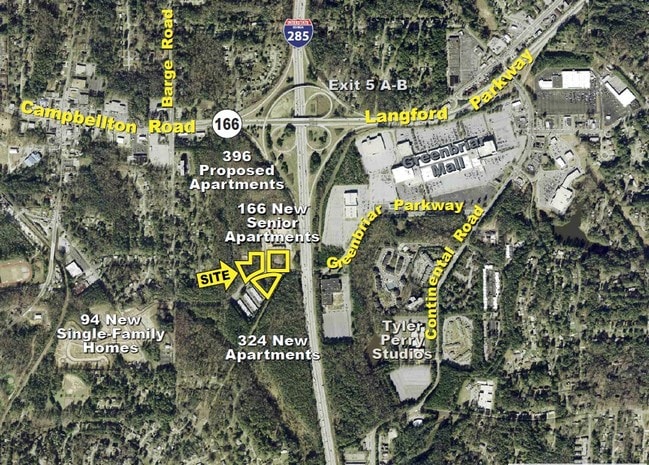
Property Record
3397 Greenbriar Pkwy Sw, Atlanta, GA 30331

NEARBY LISTINGS FOR SALE OR LEASE
Property Detail
3397 Greenbriar Pkwy Sw
Atlanta-Sandy Springs-Roswell, GA
Coventry Stn Ptrs Llc 02
14-0252-LL-076-7
KA VACANT COMM. LAND AN LAND SPILT 06
Commercialacreage
Fulton
X
Georgia
13121C0342F
2
2025
1.51 AC
2025
North Clayton/Airport
007711
Atlanta
DEMOGRAPHICS near 3397 Greenbriar Pkwy Sw
1 Mile
3 Mile
5 Mile
2024 Total Population
6,785
64,956
154,937
2029 Population
6,974
66,918
160,690
Pop Growth 2024-2029
+ 2.79%
+ 3.02%
+ 3.71%
Average Age
43
39
39
2024 Total Households
3,192
27,212
63,785
HH Growth 2024-2029
+ 3.13%
+ 3.01%
+ 3.75%
Median Household Inc
$38,923
$52,501
$54,463
Avg Household Size
2.00
2.30
2.40
2024 Avg HH Vehicles
1.00
1.00
1.00
Median Home Value
$213,203
$245,464
$257,705
Median Year Built
1977
1977
1975
Nearby Places
Map Layers
Map Styles
 Street
 Aerial
- Restaurants
- Banks
- Shops
- Fitness
- Groceries
PUBLIC TRANSPORTATION
AIRPORT
Hartsfield - Jackson Atlanta International
DRIVE
WALK
Distance
Hartsfield - Jackson Atlanta International
19 min
9.7 mi
SALE & LEASE HISTORY
LISTING DATE
SALE/LEASE

Sep 24, 2016
For Sale
Nearby Properties
Address
Land Use
TOTAL SIZE
Lot Size
Zoning
Address
Land Use
TOTAL SIZE
Lot Size
Zoning
196,294 SF
0.49 AC
R1
Address
Land Use
TOTAL SIZE
Lot Size
Zoning
356,458 SF
18.72 AC
PDMU
Address
Land Use
TOTAL SIZE
Lot Size
Zoning
802,908 SF
18.26 AC
RG3
Address
Land Use
TOTAL SIZE
Lot Size
Zoning
6,402,340 SF
22.62 AC
MF
Address
Land Use
TOTAL SIZE
Lot Size
Zoning
4,455,803 SF
16.39 AC
C2
Address
Land Use
TOTAL SIZE
Lot Size
Zoning
6,069,632 SF
26.42 AC
R4
Address
Land Use
TOTAL SIZE
Lot Size
Zoning
330,838 SF
13.71 AC
PDMU
Address
Land Use
TOTAL SIZE
Lot Size
Zoning
5,459 SF
12.97 AC
C1
Address
Land Use
TOTAL SIZE
Lot Size
Zoning
3,411,710 SF
25.97 AC
RG3
Address
Land Use
TOTAL SIZE
Lot Size
Zoning
282,610 SF
11.20 AC
C1
Address
Land Use
TOTAL SIZE
Lot Size
Zoning
235,301 SF
27.20 AC
C2MC
Address
Land Use
TOTAL SIZE
Lot Size
Zoning
364,391 SF
25.33 AC
R4
Address
Land Use
TOTAL SIZE
Lot Size
Zoning
920,396 SF
62.40 AC
R3
Address
Land Use
TOTAL SIZE
Lot Size
Zoning
663,520 SF
62.96 AC
C1
Address
Land Use
TOTAL SIZE
Lot Size
Zoning
213,314 SF
16.48 AC
C2C
Address
Land Use
TOTAL SIZE
Lot Size
Zoning
2,057,484 SF
14.78 AC
R4
Address
Land Use
TOTAL SIZE
Lot Size
Zoning
274,442 SF
20.33 AC
RG2
Address
Land Use
TOTAL SIZE
Lot Size
Zoning
3,268,352 SF
23.31 AC
RG2
Address
Land Use
TOTAL SIZE
Lot Size
Zoning
17,174,332 SF
39.44 AC
R3
Address
Land Use
TOTAL SIZE
Lot Size
Zoning
135,211 SF
51.76 AC
OI
Address
Land Use
TOTAL SIZE
Lot Size
Zoning
634,503 SF
19.94 AC
R3
Address
Land Use
TOTAL SIZE
Lot Size
Zoning
3,289,702 SF
16.23 AC
C1C
Address
Land Use
TOTAL SIZE
Lot Size
Zoning
395,218 SF
21.61 AC
A1
Address
Land Use
TOTAL SIZE
Lot Size
Zoning
602,694 SF
9.32 AC
C1
Address
Land Use
TOTAL SIZE
Lot Size
Zoning
28.58 AC
Address
Land Use
TOTAL SIZE
Lot Size
Zoning
6,834,480 SF
9.85 AC
RG3
Address
Land Use
TOTAL SIZE
Lot Size
Zoning
274,563 SF
65.24 AC
C2
Address
Land Use
TOTAL SIZE
Lot Size
Zoning
2,563,484 SF
12.54 AC
MF
Address
Land Use
TOTAL SIZE
Lot Size
Zoning
2,002,026 SF
17.51 AC
RLC
Address
Land Use
TOTAL SIZE
Lot Size
Zoning
2,963,779 SF
10.07 AC
C1
The World's #1 Commercial Real Estate Marketplace
Connect with us
© 2026 CoStar Group
The information above has been obtained from sources believed reliable. While we do not doubt its accuracy we have not verified it and make no guarantee, warranty or representation about it. It is your responsibility to independently confirm its accuracy and completeness. Any projections, opinions, assumptions, or estimates used are for example only and do not represent the current or future performance of the property. The value of this transaction to you depends on tax and other factors which should be evaluated by your tax, financial, and legal advisors. You and your advisors should conduct a careful, independent investigation of the property to determine to your satisfaction the suitability of the property for your needs.