Property Record
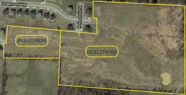
Greencrest Way, Lancaster, OH 43130
Property Detail
Greencrest Way
Columbus, OH
R 19 T 15 S 26 SE ANNEXED 2-15-01
05-32274-700
FAIRFIELD
Agriculturalland
Ohio
B and X Area of moderate flood hazard, usually the area between the limits of the 100-year and 500-year floods.
18.80 AC
2024
Fairfield County
2025
Columbus
032000
NEARBY LISTINGS FOR SALE OR LEASE
DEMOGRAPHICS near Greencrest Way
1 mile
3 mile
5 mile
2025 Total Population
5,988
37,930
55,929
2030 Population
6,340
39,811
58,627
Pop Growth 2025-2030
+ 5.88%
+ 4.96%
+ 4.82%
Average Age
40
41
42
2025 Total Households
2,432
15,731
22,712
HH Growth 2025-2030
+ 6.25%
+ 5.21%
+ 5.09%
Median Household Inc
$79,818
$62,123
$64,955
Avg Household Size
2.50
2.30
2.40
2025 Avg HH Vehicles
2.00
2.00
2.00
Median Home Value
$251,776
$189,586
$219,170
Median Year Built
1996
1964
1967
Nearby Places
Map Layers
Map Styles
 Street
 Aerial
Layers
 Traffic
 Biking
Places
Listings with unknown addresses are not visible on the map
- Restaurants
- Banks
- Shops
- Fitness
- Groceries
PUBLIC TRANSPORTATION
AIRPORT
Rickenbacker International
Drive
Walk
Distance
Rickenbacker International
38 min
25.3 mi
John Glenn Columbus International
Drive
Walk
Distance
John Glenn Columbus International
41 min
28.4 mi
Freight Ports
Port of Toledo
Drive
Walk
Distance
Port of Toledo
220 min
176.6 mi
SALE & LEASE HISTORY
LISTING DATE
SALE/LEASE

Jun 26, 2018
For Sale
Nearby Properties
Address
Land Use
TOTAL SIZE
Lot Size
Zoning
Address
Land Use
TOTAL SIZE
Lot Size
Zoning
519,532 SF
9.92 AC
Address
Land Use
TOTAL SIZE
Lot Size
Zoning
1,278,248 SF
65.57 AC
Address
Land Use
TOTAL SIZE
Lot Size
Zoning
44,800 SF
15.93 AC
Address
Land Use
TOTAL SIZE
Lot Size
Zoning
45,633 SF
13.92 AC
Address
Land Use
TOTAL SIZE
Lot Size
Zoning
895,709 SF
24.44 AC
Address
Land Use
TOTAL SIZE
Lot Size
Zoning
85,331 SF
18.94 AC
Address
Land Use
TOTAL SIZE
Lot Size
Zoning
111,535 SF
4.80 AC
Address
Land Use
TOTAL SIZE
Lot Size
Zoning
88,522 SF
36.77 AC
Address
Land Use
TOTAL SIZE
Lot Size
Zoning
88,522 SF
37.42 AC
Address
Land Use
TOTAL SIZE
Lot Size
Zoning
141,894 SF
68.74 AC
Address
Land Use
TOTAL SIZE
Lot Size
Zoning
69,461 SF
13.72 AC
Address
Land Use
TOTAL SIZE
Lot Size
Zoning
62,550 SF
14.82 AC
Address
Land Use
TOTAL SIZE
Lot Size
Zoning
59,538 SF
22.24 AC
Address
Land Use
TOTAL SIZE
Lot Size
Zoning
67,322 SF
16.45 AC
Address
Land Use
TOTAL SIZE
Lot Size
Zoning
56,826 SF
7.04 AC
Address
Land Use
TOTAL SIZE
Lot Size
Zoning
34,020 SF
20.93 AC
Address
Land Use
TOTAL SIZE
Lot Size
Zoning
330,207 SF
17.97 AC
Address
Land Use
TOTAL SIZE
Lot Size
Zoning
155,985 SF
13.70 AC
Address
Land Use
TOTAL SIZE
Lot Size
Zoning
61,657 SF
10.45 AC
Address
Land Use
TOTAL SIZE
Lot Size
Zoning
229,660 SF
21.76 AC
Address
Land Use
TOTAL SIZE
Lot Size
Zoning
54,558 SF
11.24 AC
Address
Land Use
TOTAL SIZE
Lot Size
Zoning
330,207 SF
17.97 AC
Address
Land Use
TOTAL SIZE
Lot Size
Zoning
149,903 SF
43.98 AC
Address
Land Use
TOTAL SIZE
Lot Size
Zoning
144,184 SF
42.05 AC
Address
Land Use
TOTAL SIZE
Lot Size
Zoning
76,509 SF
7.21 AC
Address
Land Use
TOTAL SIZE
Lot Size
Zoning
192,310 SF
18.39 AC
Address
Land Use
TOTAL SIZE
Lot Size
Zoning
126,928 SF
12.29 AC
Address
Land Use
TOTAL SIZE
Lot Size
Zoning
201,304 SF
17.11 AC
Address
Land Use
TOTAL SIZE
Lot Size
Zoning
45,361 SF
4.72 AC
Address
Land Use
TOTAL SIZE
Lot Size
Zoning
177,448 SF
16.40 AC
The World's #1 Commercial Real Estate Marketplace
Connect with us
© 2026 CoStar Group
The information above has been obtained from sources believed reliable. While we do not doubt its accuracy we have not verified it and make no guarantee, warranty or representation about it. It is your responsibility to independently confirm its accuracy and completeness. Any projections, opinions, assumptions, or estimates used are for example only and do not represent the current or future performance of the property. The value of this transaction to you depends on tax and other factors which should be evaluated by your tax, financial, and legal advisors. You and your advisors should conduct a careful, independent investigation of the property to determine to your satisfaction the suitability of the property for your needs.