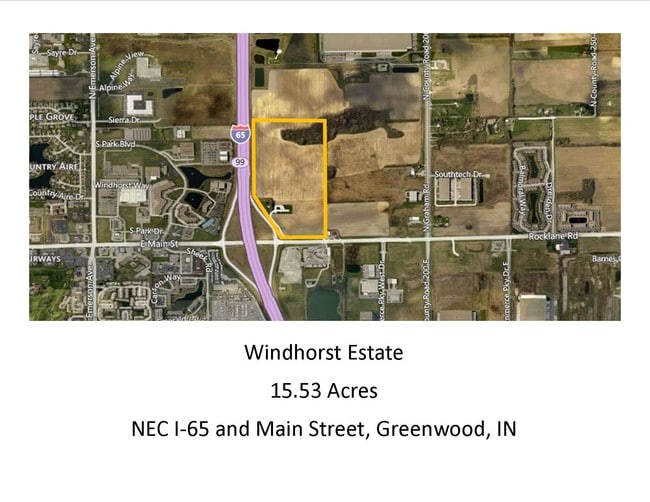
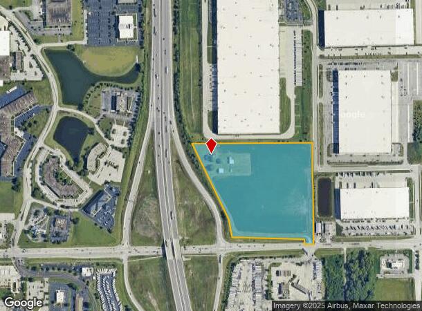
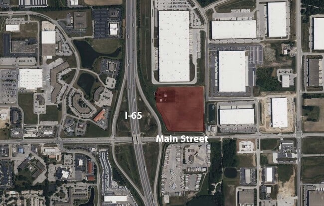
Property Record
Greenwood Rd, Greenwood, IN 46143
NEARBY LISTINGS FOR SALE OR LEASE
-
-
-
SW Corner County Line Road and Five Points Rd
Greenwood, IN 46143
Rent Upon Request
78.47 AC Lots
Land
-
-
-
-
-
View all Greenwood listings for sale on LoopNet.com
Property Detail
Greenwood Rd
Indianapolis-Carmel-Anderson, IN
Johnson
41-02-34-013-005.000-030
Indiana
Ruralagriculturalresidence
15.54 AC
X
Greenwood
18081C0127D
Indianapolis
2,768 SF
DEMOGRAPHICS near Greenwood Rd
1 Mile
3 Mile
5 Mile
2024 Total Population
6,296
55,964
139,952
2029 Population
6,772
58,401
143,918
Pop Growth 2024-2029
+ 7.56%
+ 4.35%
+ 2.83%
Average Age
39
39
38
2024 Total Households
2,777
22,332
53,777
HH Growth 2024-2029
+ 7.67%
+ 4.49%
+ 2.93%
Median Household Inc
$77,877
$72,304
$74,174
Avg Household Size
2.30
2.40
2.50
2024 Avg HH Vehicles
2.00
2.00
2.00
Median Home Value
$217,273
$199,652
$213,805
Median Year Built
1994
1994
1991
Nearby Places
Map Layers
Map Styles
 Street
 Aerial
- Restaurants
- Banks
- Shops
- Fitness
- Groceries
PUBLIC TRANSPORTATION
AIRPORT
Indianapolis International
DRIVE
WALK
Distance
Indianapolis International
38 min
23.7 mi
Freight Ports
Port of Toledo
DRIVE
WALK
Distance
Port of Toledo
283 min
235.6 mi
SALE & LEASE HISTORY
LISTING DATE
SALE/LEASE

Sep 24, 2016
For Sale
Sep 15, 2017
For Sale
Jun 25, 2024
For Sale
Nearby Properties
Address
Land Use
TOTAL SIZE
Lot Size
Zoning
Address
Land Use
TOTAL SIZE
Lot Size
Zoning
295,161 SF
70.54 AC
Address
Land Use
TOTAL SIZE
Lot Size
Zoning
31,217 SF
105.06 AC
ZO01
Address
Land Use
TOTAL SIZE
Lot Size
Zoning
816,376 SF
65.10 AC
Address
Land Use
TOTAL SIZE
Lot Size
Zoning
615,440 SF
78.64 AC
Address
Land Use
TOTAL SIZE
Lot Size
Zoning
10,540 SF
49.19 AC
ZO01
Address
Land Use
TOTAL SIZE
Lot Size
Zoning
670,880 SF
43.43 AC
Address
Land Use
TOTAL SIZE
Lot Size
Zoning
5,846 SF
43.64 AC
ZO01
Address
Land Use
TOTAL SIZE
Lot Size
Zoning
420,084 SF
23.83 AC
Address
Land Use
TOTAL SIZE
Lot Size
Zoning
799,575 SF
37.56 AC
Address
Land Use
TOTAL SIZE
Lot Size
Zoning
446,500 SF
45.43 AC
Address
Land Use
TOTAL SIZE
Lot Size
Zoning
493,560 SF
31.39 AC
Address
Land Use
TOTAL SIZE
Lot Size
Zoning
511,680 SF
37.57 AC
Address
Land Use
TOTAL SIZE
Lot Size
Zoning
667,500 SF
33.46 AC
Address
Land Use
TOTAL SIZE
Lot Size
Zoning
5,576 SF
14.15 AC
ZO01
Address
Land Use
TOTAL SIZE
Lot Size
Zoning
581,612 SF
33.53 AC
Address
Land Use
TOTAL SIZE
Lot Size
Zoning
81,996 SF
8.56 AC
Address
Land Use
TOTAL SIZE
Lot Size
Zoning
4,970 SF
24.77 AC
Address
Land Use
TOTAL SIZE
Lot Size
Zoning
470,000 SF
22.75 AC
Address
Land Use
TOTAL SIZE
Lot Size
Zoning
181,458 SF
6 AC
Address
Land Use
TOTAL SIZE
Lot Size
Zoning
273,000 SF
22.28 AC
Address
Land Use
TOTAL SIZE
Lot Size
Zoning
1,968 SF
37.45 AC
Address
Land Use
TOTAL SIZE
Lot Size
Zoning
612,000 SF
31.01 AC
Address
Land Use
TOTAL SIZE
Lot Size
Zoning
21,784 SF
30.75 AC
ZO01
Address
Land Use
TOTAL SIZE
Lot Size
Zoning
331,200 SF
23.40 AC
Address
Land Use
TOTAL SIZE
Lot Size
Zoning
4,027 SF
24.71 AC
Address
Land Use
TOTAL SIZE
Lot Size
Zoning
5,401 SF
21.94 AC
ZO01
Address
Land Use
TOTAL SIZE
Lot Size
Zoning
4,722 SF
25.71 AC
Address
Land Use
TOTAL SIZE
Lot Size
Zoning
4,478 SF
12.05 AC
Address
Land Use
TOTAL SIZE
Lot Size
Zoning
146,716 SF
25.43 AC
Address
Land Use
TOTAL SIZE
Lot Size
Zoning
110,598 SF
22.82 AC
ZO01
The World's #1 Commercial Real Estate Marketplace
Connect with us
© 2025 CoStar Group
The information above has been obtained from sources believed reliable. While we do not doubt its accuracy we have not verified it and make no guarantee, warranty or representation about it. It is your responsibility to independently confirm its accuracy and completeness. Any projections, opinions, assumptions, or estimates used are for example only and do not represent the current or future performance of the property. The value of this transaction to you depends on tax and other factors which should be evaluated by your tax, financial, and legal advisors. You and your advisors should conduct a careful, independent investigation of the property to determine to your satisfaction the suitability of the property for your needs.