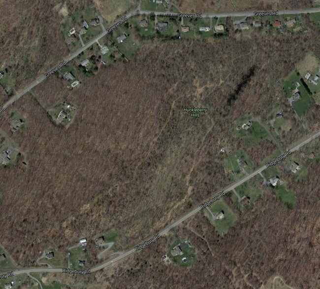
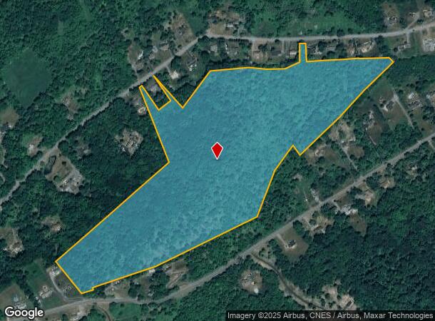
Property Record
Greeves Rd, Wawayanda, NY 10958
NEARBY LISTINGS FOR SALE OR LEASE
Property Detail
Greeves Rd
335600-012-000-0001-037.100-0000
Orange
Recreationalacreage
New York
X
37.10
36071C0268E
50.60 AC
2024
Monroe
2024
Northern New Jersey
011802
New York-Jersey City-White Plains, NY-NJ
DEMOGRAPHICS near Greeves Rd
1 Mile
3 Mile
5 Mile
2024 Total Population
797
16,016
54,932
2029 Population
802
16,376
55,896
Pop Growth 2024-2029
+ 0.63%
+ 2.25%
+ 1.75%
Average Age
42
39
40
2024 Total Households
265
6,167
20,071
HH Growth 2024-2029
+ 0.75%
+ 2.50%
+ 1.95%
Median Household Inc
$124,323
$78,206
$76,159
Avg Household Size
3.00
2.50
2.60
2024 Avg HH Vehicles
2.00
2.00
2.00
Median Home Value
$331,739
$275,255
$273,259
Median Year Built
1979
1988
1971
Nearby Places
- Restaurants
- Banks
- Shops
- Fitness
- Groceries
PUBLIC TRANSPORTATION
COMMUTER RAIL
Middletown New York (Bergen County/Port Jervis Line - NJ Transit Commuter Rail (NJ Transit), Main/Port Jervis Line - NJ Transit Commuter Rail (NJ Transit))
DRIVE
WALK
Distance
Middletown New York (Bergen County/Port Jervis Line - NJ Transit Commuter Rail (NJ Transit), Main/Port Jervis Line - NJ Transit Commuter Rail (NJ Transit))
19 min
8.6 mi
AIRPORT
New York Stewart International
DRIVE
WALK
Distance
New York Stewart International
37 min
23.8 mi
Freight Ports
Port Newark Container Terminal
DRIVE
WALK
Distance
Port Newark Container Terminal
96 min
70.3 mi
SALE & LEASE HISTORY
LISTING DATE
SALE/LEASE

Mar 28, 2017
For Sale
Nearby Properties
Address
Land Use
TOTAL SIZE
Lot Size
Zoning
Address
Land Use
TOTAL SIZE
Lot Size
Zoning
72.50 AC
MC 1
Address
Land Use
TOTAL SIZE
Lot Size
Zoning
433,953 SF
90.64 AC
04200
Address
Land Use
TOTAL SIZE
Lot Size
Zoning
499,762 SF
67.30 AC
SR-MC1
Address
Land Use
TOTAL SIZE
Lot Size
Zoning
40.40 AC
I-2
Address
Land Use
TOTAL SIZE
Lot Size
Zoning
240,800 SF
29.50 AC
MC 1
Address
Land Use
TOTAL SIZE
Lot Size
Zoning
29,950 SF
3 AC
TC-1
Address
Land Use
TOTAL SIZE
Lot Size
Zoning
26,659 SF
15.80 AC
MC 2
Address
Land Use
TOTAL SIZE
Lot Size
Zoning
17.60 AC
R-1
Address
Land Use
TOTAL SIZE
Lot Size
Zoning
14.70 AC
MC 1
Address
Land Use
TOTAL SIZE
Lot Size
Zoning
50,700 SF
7.70 AC
TC-1
Address
Land Use
TOTAL SIZE
Lot Size
Zoning
26,156 SF
0.01 AC
TC-1
Address
Land Use
TOTAL SIZE
Lot Size
Zoning
5,832 SF
2.30 AC
TC-1
Address
Land Use
TOTAL SIZE
Lot Size
Zoning
4 AC
TC2
Address
Land Use
TOTAL SIZE
Lot Size
Zoning
7 AC
C-3
Address
Land Use
TOTAL SIZE
Lot Size
Zoning
60,321 SF
10.70 AC
TC2
Address
Land Use
TOTAL SIZE
Lot Size
Zoning
6.80 AC
MC 1
Address
Land Use
TOTAL SIZE
Lot Size
Zoning
41,728 SF
5 AC
TC-1
Address
Land Use
TOTAL SIZE
Lot Size
Zoning
22,574 SF
15 AC
04200
Address
Land Use
TOTAL SIZE
Lot Size
Zoning
57.40 AC
MC 1
Address
Land Use
TOTAL SIZE
Lot Size
Zoning
726 SF
40.30 AC
C-3
Address
Land Use
TOTAL SIZE
Lot Size
Zoning
4.90 AC
Address
Land Use
TOTAL SIZE
Lot Size
Zoning
64,320 SF
11.05 AC
4100
Address
Land Use
TOTAL SIZE
Lot Size
Zoning
12.60 AC
R-1
Address
Land Use
TOTAL SIZE
Lot Size
Zoning
3,220 SF
100 AC
04200
Address
Land Use
TOTAL SIZE
Lot Size
Zoning
207.90 AC
04200
Address
Land Use
TOTAL SIZE
Lot Size
Zoning
24.90 AC
R-AH
Address
Land Use
TOTAL SIZE
Lot Size
Zoning
83,386 SF
43.20 AC
04200
Address
Land Use
TOTAL SIZE
Lot Size
Zoning
11.50 AC
SR-3B
Address
Land Use
TOTAL SIZE
Lot Size
Zoning
24.70 AC
MC 1
Address
Land Use
TOTAL SIZE
Lot Size
Zoning
22,144 SF
5.60 AC
MC 2
The World's #1 Commercial Real Estate Marketplace
Connect with us
© 2025 CoStar Group
The information above has been obtained from sources believed reliable. While we do not doubt its accuracy we have not verified it and make no guarantee, warranty or representation about it. It is your responsibility to independently confirm its accuracy and completeness. Any projections, opinions, assumptions, or estimates used are for example only and do not represent the current or future performance of the property. The value of this transaction to you depends on tax and other factors which should be evaluated by your tax, financial, and legal advisors. You and your advisors should conduct a careful, independent investigation of the property to determine to your satisfaction the suitability of the property for your needs.