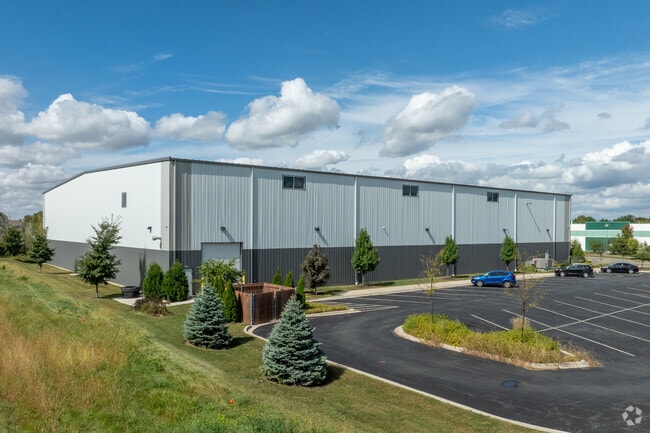
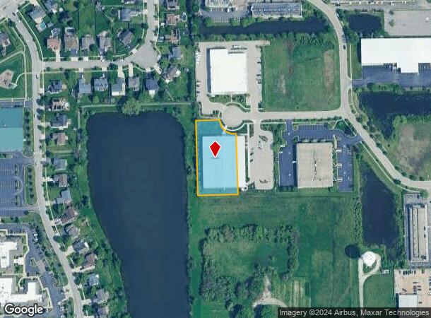
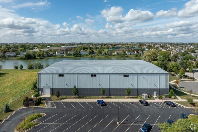
Property Record
Gregory Ct, Shorewood, IL 60404
NEARBY LISTINGS FOR SALE OR LEASE
Property Detail
Gregory Ct
Chicago-Naperville-Elgin, IL-IN-WI
Crossroads Business Park Sub
05-06-04-401-006
LOT 10 IN CROSSROADS BUSINESS PARK SUBDIVISION, A SUB OF PRT OF THE E 1/2 OF THE SE 1/4 OF SEC 4, T35N R9E.
Commercialnec
Will
X
Illinois
17197C0137G
10
2024
1.13 AC
2024
Joliet Area
883213
Chicago
DEMOGRAPHICS near Gregory Ct
1 Mile
3 Mile
5 Mile
2024 Total Population
10,631
69,535
151,342
2029 Population
10,570
69,497
152,484
Pop Growth 2024-2029
(0.57%)
(0.05%)
+ 0.75%
Average Age
39
39
39
2024 Total Households
3,659
23,507
52,966
HH Growth 2024-2029
(0.57%)
(0.11%)
+ 0.56%
Median Household Inc
$90,148
$105,052
$91,181
Avg Household Size
2.80
2.90
2.80
2024 Avg HH Vehicles
2.00
2.00
2.00
Median Home Value
$251,191
$259,299
$249,251
Median Year Built
2001
1997
1994
Nearby Places
Map Layers
Map Styles
 Street
 Aerial
- Restaurants
- Banks
- Shops
- Fitness
- Groceries
PUBLIC TRANSPORTATION
COMMUTER RAIL
Joliet Station (Heritage Corridor Line - Northeast Illinois Regional Commuter Railroad (Metra), Rock Island District Line - Northeast Illinois Regional Commuter Railroad (Metra))
DRIVE
WALK
Distance
Joliet Station (Heritage Corridor Line - Northeast Illinois Regional Commuter Railroad (Metra), Rock Island District Line - Northeast Illinois Regional Commuter Railroad (Metra))
18 min
7.3 mi
AIRPORT
Chicago Midway International
DRIVE
WALK
Distance
Chicago Midway International
48 min
35.1 mi
Chicago O'Hare International
DRIVE
WALK
Distance
Chicago O'Hare International
65 min
46.5 mi
Nearby Properties
Address
Land Use
TOTAL SIZE
Lot Size
Zoning
Address
Land Use
TOTAL SIZE
Lot Size
Zoning
50.58 AC
Address
Land Use
TOTAL SIZE
Lot Size
Zoning
51.97 AC
Address
Land Use
TOTAL SIZE
Lot Size
Zoning
5.12 AC
Address
Land Use
TOTAL SIZE
Lot Size
Zoning
Address
Land Use
TOTAL SIZE
Lot Size
Zoning
Address
Land Use
TOTAL SIZE
Lot Size
Zoning
84,899 SF
3.98 AC
Address
Land Use
TOTAL SIZE
Lot Size
Zoning
8.46 AC
Address
Land Use
TOTAL SIZE
Lot Size
Zoning
64,046 SF
5.41 AC
Address
Land Use
TOTAL SIZE
Lot Size
Zoning
123,698 SF
10.88 AC
Address
Land Use
TOTAL SIZE
Lot Size
Zoning
105,825 SF
2.62 AC
Address
Land Use
TOTAL SIZE
Lot Size
Zoning
65,977 SF
5.07 AC
Address
Land Use
TOTAL SIZE
Lot Size
Zoning
52,132 SF
6.48 AC
Address
Land Use
TOTAL SIZE
Lot Size
Zoning
68,154 SF
6.94 AC
Address
Land Use
TOTAL SIZE
Lot Size
Zoning
64,624 SF
12.04 AC
Address
Land Use
TOTAL SIZE
Lot Size
Zoning
200,000 SF
5.82 AC
Address
Land Use
TOTAL SIZE
Lot Size
Zoning
2.64 AC
Address
Land Use
TOTAL SIZE
Lot Size
Zoning
16.46 AC
Address
Land Use
TOTAL SIZE
Lot Size
Zoning
8.55 AC
Address
Land Use
TOTAL SIZE
Lot Size
Zoning
106,715 SF
10.96 AC
Address
Land Use
TOTAL SIZE
Lot Size
Zoning
70,600 SF
5 AC
Address
Land Use
TOTAL SIZE
Lot Size
Zoning
45,838 SF
5.06 AC
Address
Land Use
TOTAL SIZE
Lot Size
Zoning
36,756 SF
4.06 AC
Address
Land Use
TOTAL SIZE
Lot Size
Zoning
2.58 AC
Address
Land Use
TOTAL SIZE
Lot Size
Zoning
38,835 SF
6.29 AC
Address
Land Use
TOTAL SIZE
Lot Size
Zoning
Address
Land Use
TOTAL SIZE
Lot Size
Zoning
145.35 AC
Address
Land Use
TOTAL SIZE
Lot Size
Zoning
3.27 AC
Address
Land Use
TOTAL SIZE
Lot Size
Zoning
34,557 SF
2.63 AC
Address
Land Use
TOTAL SIZE
Lot Size
Zoning
14,361 SF
2.15 AC
Address
Land Use
TOTAL SIZE
Lot Size
Zoning
6.87 AC
The World's #1 Commercial Real Estate Marketplace
Connect with us
© 2025 CoStar Group
The information above has been obtained from sources believed reliable. While we do not doubt its accuracy we have not verified it and make no guarantee, warranty or representation about it. It is your responsibility to independently confirm its accuracy and completeness. Any projections, opinions, assumptions, or estimates used are for example only and do not represent the current or future performance of the property. The value of this transaction to you depends on tax and other factors which should be evaluated by your tax, financial, and legal advisors. You and your advisors should conduct a careful, independent investigation of the property to determine to your satisfaction the suitability of the property for your needs.