Property Record
Grenard Cir, North Port, FL 34288
This Property Is For Sale
NEARBY LISTINGS FOR SALE OR LEASE
Property Detail
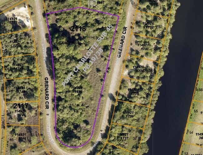
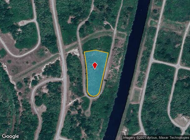
Grenard Cir
North Port-Sarasota-Bradenton, FL
Port Charlotte Sub 45
1149-21-1816
TRACT RRR 45TH ADD TO PORT CHARLOTTE
Residentialacreage
Sarasota
X
Florida
12015C0062G
2.17 AC
2023
Sarasota Outlying
2024
Tampa/St Petersburg
002747
DEMOGRAPHICS near Grenard Cir
1 Mile
3 Mile
5 Mile
2024 Total Population
405
27,677
87,949
2029 Population
477
32,006
102,084
Pop Growth 2024-2029
+ 17.78%
+ 15.64%
+ 16.07%
Average Age
39
46
48
2024 Total Households
140
11,159
37,486
HH Growth 2024-2029
+ 17.86%
+ 15.78%
+ 16.33%
Median Household Inc
$89,772
$67,264
$61,322
Avg Household Size
2.90
2.40
2.30
2024 Avg HH Vehicles
2.00
2.00
2.00
Median Home Value
$233,333
$241,128
$228,328
Median Year Built
2010
1995
1990
Nearby Places
- Restaurants
- Banks
- Shops
- Fitness
- Groceries
PUBLIC TRANSPORTATION
AIRPORT
Punta Gorda
DRIVE
WALK
Distance
Punta Gorda
24 min
14.3 mi
Freight Ports
Port Manatee
DRIVE
WALK
Distance
Port Manatee
83 min
63.0 mi
Nearby Properties
Address
Land Use
TOTAL SIZE
Lot Size
Zoning
Address
Land Use
TOTAL SIZE
Lot Size
Zoning
202,009 SF
20.89 AC
PD
Address
Land Use
TOTAL SIZE
Lot Size
Zoning
204,731 SF
16.11 AC
PD
Address
Land Use
TOTAL SIZE
Lot Size
Zoning
229,973 SF
21.33 AC
PD
Address
Land Use
TOTAL SIZE
Lot Size
Zoning
217,784 SF
38.63 AC
PD
Address
Land Use
TOTAL SIZE
Lot Size
Zoning
132,955 SF
32.12 AC
GU
Address
Land Use
TOTAL SIZE
Lot Size
Zoning
102,337 SF
10.43 AC
RSF3.5
Address
Land Use
TOTAL SIZE
Lot Size
Zoning
73,222 SF
5.14 AC
PD
Address
Land Use
TOTAL SIZE
Lot Size
Zoning
50,970 SF
9.74 AC
RSF3.5
Address
Land Use
TOTAL SIZE
Lot Size
Zoning
41,148 SF
155.85 AC
RSF-3
Address
Land Use
TOTAL SIZE
Lot Size
Zoning
83,180 SF
9.31 AC
PD
Address
Land Use
TOTAL SIZE
Lot Size
Zoning
95,547 SF
14.06 AC
PD
Address
Land Use
TOTAL SIZE
Lot Size
Zoning
37,045 SF
21.20 AC
PD
Address
Land Use
TOTAL SIZE
Lot Size
Zoning
35,951 SF
24.23 AC
PD
Address
Land Use
TOTAL SIZE
Lot Size
Zoning
27,082 SF
2.05 AC
PD
Address
Land Use
TOTAL SIZE
Lot Size
Zoning
67,750 SF
15.60 AC
OMI
Address
Land Use
TOTAL SIZE
Lot Size
Zoning
23,798 SF
1.71 AC
PD
Address
Land Use
TOTAL SIZE
Lot Size
Zoning
82.27 AC
PD
Address
Land Use
TOTAL SIZE
Lot Size
Zoning
10,302 SF
2.37 AC
PD
Address
Land Use
TOTAL SIZE
Lot Size
Zoning
31.81 AC
PD
Address
Land Use
TOTAL SIZE
Lot Size
Zoning
7.81 AC
PD
Address
Land Use
TOTAL SIZE
Lot Size
Zoning
30,928 SF
41.30 AC
PKR
Address
Land Use
TOTAL SIZE
Lot Size
Zoning
26,870 SF
3.32 AC
CG
Address
Land Use
TOTAL SIZE
Lot Size
Zoning
27.59 AC
PD
Address
Land Use
TOTAL SIZE
Lot Size
Zoning
31,637 SF
4.02 AC
RMF10
Address
Land Use
TOTAL SIZE
Lot Size
Zoning
662.52 AC
EC
Address
Land Use
TOTAL SIZE
Lot Size
Zoning
646.09 AC
EC
Address
Land Use
TOTAL SIZE
Lot Size
Zoning
35,352 SF
2.07 AC
IG
Address
Land Use
TOTAL SIZE
Lot Size
Zoning
575.38 AC
EC
Address
Land Use
TOTAL SIZE
Lot Size
Zoning
36,049 SF
4.12 AC
PD
Address
Land Use
TOTAL SIZE
Lot Size
Zoning
87,639 SF
12.23 AC
RSF3.5
The World's #1 Commercial Real Estate Marketplace
Connect with us
© 2025 CoStar Group
The information above has been obtained from sources believed reliable. While we do not doubt its accuracy we have not verified it and make no guarantee, warranty or representation about it. It is your responsibility to independently confirm its accuracy and completeness. Any projections, opinions, assumptions, or estimates used are for example only and do not represent the current or future performance of the property. The value of this transaction to you depends on tax and other factors which should be evaluated by your tax, financial, and legal advisors. You and your advisors should conduct a careful, independent investigation of the property to determine to your satisfaction the suitability of the property for your needs.