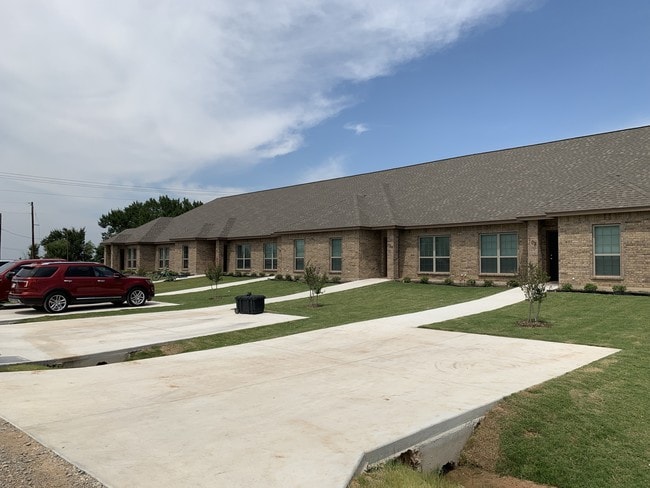
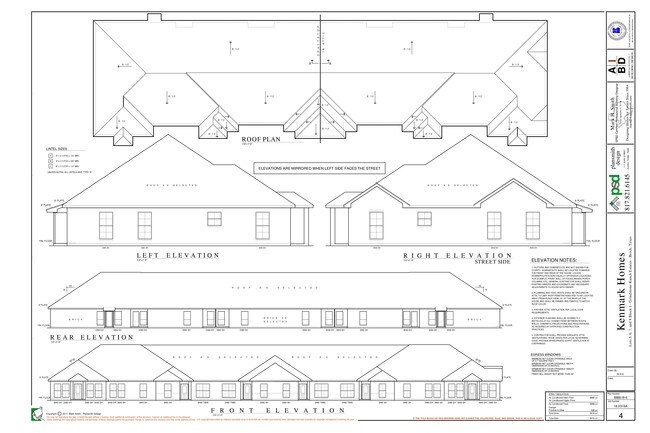
Property Record
Grindstone Rd, Weatherford, TX 76087


Property Detail
Grindstone Rd
Dallas-Fort Worth-Arlington, TX
ACRES: 2.002 LOT: 5 BLK: 1 SUBD: GRINDSTONE RANCH ESTATES
12943-001-005-00
PARKER
Apartment
Texas
B and X Area of moderate flood hazard, usually the area between the limits of the 100-year and 500-year floods.
5
2024
2 AC
2025
Outer Parker County
140603
Dallas/Ft Worth
8,720 SF
NEARBY LISTINGS FOR SALE OR LEASE
-
-
View all Weatherford listings for sale on LoopNet.com
DEMOGRAPHICS near Grindstone Rd
1 mile
3 mile
5 mile
2025 Total Population
453
2,885
7,190
2030 Population
526
3,343
8,334
Pop Growth 2025-2030
+ 16.11%
+ 15.88%
+ 15.91%
Average Age
38
38
38
2025 Total Households
147
958
2,411
HH Growth 2025-2030
+ 15.65%
+ 15.03%
+ 15.10%
Median Household Inc
$145,237
$131,779
$125,651
Avg Household Size
3.00
3.00
3.00
2025 Avg HH Vehicles
2.00
2.00
2.00
Median Home Value
$618,055
$579,518
$548,395
Median Year Built
2009
2008
2007
Nearby Places
Map Layers
Map Styles
 Street
 Aerial
Layers
 Traffic
 Biking
Places
Listings with unknown addresses are not visible on the map
- Restaurants
- Banks
- Shops
- Fitness
- Groceries
SALE & LEASE HISTORY
LISTING DATE
SALE/LEASE

Jul 27, 2019
For Sale
Nearby Properties
Address
Land Use
TOTAL SIZE
Lot Size
Zoning
Address
Land Use
TOTAL SIZE
Lot Size
Zoning
57,200 SF
9.71 AC
Address
Land Use
TOTAL SIZE
Lot Size
Zoning
7,211 SF
4.32 AC
Address
Land Use
TOTAL SIZE
Lot Size
Zoning
3,071 SF
160.89 AC
Address
Land Use
TOTAL SIZE
Lot Size
Zoning
4,680 SF
12 AC
Address
Land Use
TOTAL SIZE
Lot Size
Zoning
35,500 SF
2 AC
Address
Land Use
TOTAL SIZE
Lot Size
Zoning
6,426 SF
1 AC
Address
Land Use
TOTAL SIZE
Lot Size
Zoning
17,276 SF
52.14 AC
Address
Land Use
TOTAL SIZE
Lot Size
Zoning
5,421 SF
4.97 AC
Address
Land Use
TOTAL SIZE
Lot Size
Zoning
15,455 SF
5 AC
Address
Land Use
TOTAL SIZE
Lot Size
Zoning
11,352 SF
0.93 AC
Address
Land Use
TOTAL SIZE
Lot Size
Zoning
9,240 SF
1.50 AC
Address
Land Use
TOTAL SIZE
Lot Size
Zoning
10,920 SF
2 AC
Address
Land Use
TOTAL SIZE
Lot Size
Zoning
18,000 SF
6.92 AC
Address
Land Use
TOTAL SIZE
Lot Size
Zoning
8,720 SF
2 AC
Address
Land Use
TOTAL SIZE
Lot Size
Zoning
8,720 SF
2 AC
Address
Land Use
TOTAL SIZE
Lot Size
Zoning
8,404 SF
1.28 AC
Address
Land Use
TOTAL SIZE
Lot Size
Zoning
8,720 SF
2.73 AC
Address
Land Use
TOTAL SIZE
Lot Size
Zoning
7,484 SF
2 AC
Address
Land Use
TOTAL SIZE
Lot Size
Zoning
10,162 SF
1.67 AC
Address
Land Use
TOTAL SIZE
Lot Size
Zoning
8,372 SF
2.50 AC
Address
Land Use
TOTAL SIZE
Lot Size
Zoning
7.55 AC
Address
Land Use
TOTAL SIZE
Lot Size
Zoning
8,404 SF
1.01 AC
Address
Land Use
TOTAL SIZE
Lot Size
Zoning
8,404 SF
1.01 AC
Address
Land Use
TOTAL SIZE
Lot Size
Zoning
8,404 SF
1.29 AC
Address
Land Use
TOTAL SIZE
Lot Size
Zoning
2,611 SF
10.40 AC
Address
Land Use
TOTAL SIZE
Lot Size
Zoning
10,982 SF
1.02 AC
Address
Land Use
TOTAL SIZE
Lot Size
Zoning
3,375 SF
1.17 AC
The World's #1 Commercial Real Estate Marketplace
Connect with us
© 2026 CoStar Group
The information above has been obtained from sources believed reliable. While we do not doubt its accuracy we have not verified it and make no guarantee, warranty or representation about it. It is your responsibility to independently confirm its accuracy and completeness. Any projections, opinions, assumptions, or estimates used are for example only and do not represent the current or future performance of the property. The value of this transaction to you depends on tax and other factors which should be evaluated by your tax, financial, and legal advisors. You and your advisors should conduct a careful, independent investigation of the property to determine to your satisfaction the suitability of the property for your needs.