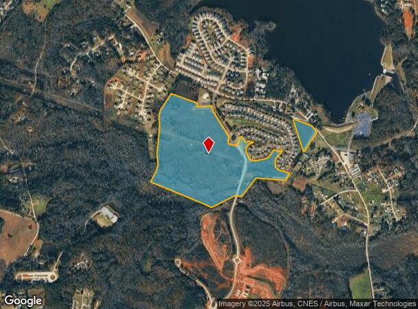
Property Record
Groce Meadow Rd, Taylors, SC 29687

NEARBY LISTINGS FOR SALE OR LEASE
-
-
View all Taylors listings for sale on LoopNet.com
Property Detail
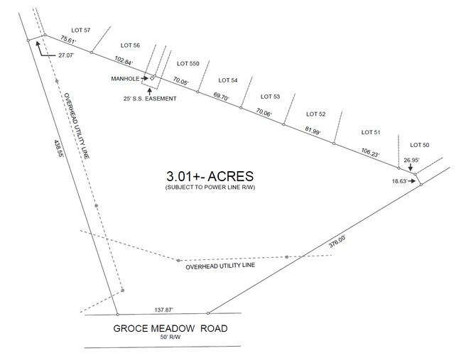
Groce Meadow Rd
0633.01-01-012.00
David M Ballenger Prop
Residentialacreage
Greenville
AE
South Carolina
45045C0331F
012.00
2025
69.08 AC
2024
Travelers Rest
002610
Greenville/Spartanburg
3,024 SF
Greenville-Anderson-Mauldin, SC
DEMOGRAPHICS near Groce Meadow Rd
1 Mile
3 Mile
5 Mile
2024 Total Population
2,818
19,206
53,325
2029 Population
3,152
21,278
58,968
Pop Growth 2024-2029
+ 11.85%
+ 10.79%
+ 10.58%
Average Age
42
41
41
2024 Total Households
1,087
7,294
20,877
HH Growth 2024-2029
+ 11.96%
+ 10.86%
+ 10.67%
Median Household Inc
$90,873
$84,704
$70,247
Avg Household Size
2.60
2.60
2.50
2024 Avg HH Vehicles
2.00
2.00
2.00
Median Home Value
$266,109
$263,326
$246,816
Median Year Built
2006
2001
1995
Nearby Places
Map Layers
Map Styles
 Street
 Aerial
- Restaurants
- Banks
- Shops
- Fitness
- Groceries
PUBLIC TRANSPORTATION
AIRPORT
Greenville Spartanburg International
DRIVE
WALK
Distance
Greenville Spartanburg International
28 min
12.3 mi
Freight Ports
North Charleston Terminal
DRIVE
WALK
Distance
North Charleston Terminal
251 min
214.1 mi
Nearby Properties
Address
Land Use
TOTAL SIZE
Lot Size
Zoning
Address
Land Use
TOTAL SIZE
Lot Size
Zoning
51.82 AC
Address
Land Use
TOTAL SIZE
Lot Size
Zoning
83.58 AC
RS
Address
Land Use
TOTAL SIZE
Lot Size
Zoning
82.10 AC
S1
Address
Land Use
TOTAL SIZE
Lot Size
Zoning
74.10 AC
RS
Address
Land Use
TOTAL SIZE
Lot Size
Zoning
71.11 AC
RS
Address
Land Use
TOTAL SIZE
Lot Size
Zoning
60.30 AC
RS
Address
Land Use
TOTAL SIZE
Lot Size
Zoning
42 AC
UNZONED
Address
Land Use
TOTAL SIZE
Lot Size
Zoning
76.50 AC
RS
Address
Land Use
TOTAL SIZE
Lot Size
Zoning
1,390 SF
4.50 AC
UNZONED
Address
Land Use
TOTAL SIZE
Lot Size
Zoning
5.29 AC
UNZONED
Address
Land Use
TOTAL SIZE
Lot Size
Zoning
29.40 AC
NZ
Address
Land Use
TOTAL SIZE
Lot Size
Zoning
1,423 SF
39.30 AC
UNZONED
Address
Land Use
TOTAL SIZE
Lot Size
Zoning
1,588 SF
32.60 AC
UNZONED
Address
Land Use
TOTAL SIZE
Lot Size
Zoning
21.99 AC
UNZONED
Address
Land Use
TOTAL SIZE
Lot Size
Zoning
21.14 AC
RS
Address
Land Use
TOTAL SIZE
Lot Size
Zoning
18.80 AC
UNZONED
Address
Land Use
TOTAL SIZE
Lot Size
Zoning
952 SF
14.28 AC
RS
Address
Land Use
TOTAL SIZE
Lot Size
Zoning
34.14 AC
AG-20
Address
Land Use
TOTAL SIZE
Lot Size
Zoning
1,440 SF
7.32 AC
UNZONED
Address
Land Use
TOTAL SIZE
Lot Size
Zoning
24 AC
UNZONED
Address
Land Use
TOTAL SIZE
Lot Size
Zoning
13.86 AC
UNZONED
Address
Land Use
TOTAL SIZE
Lot Size
Zoning
16.70 AC
UNZONED
Address
Land Use
TOTAL SIZE
Lot Size
Zoning
1,202 SF
21.30 AC
UNZONED
Address
Land Use
TOTAL SIZE
Lot Size
Zoning
0.78 AC
UNZONED
Address
Land Use
TOTAL SIZE
Lot Size
Zoning
19 AC
UNZONED
Address
Land Use
TOTAL SIZE
Lot Size
Zoning
13 AC
RS
Address
Land Use
TOTAL SIZE
Lot Size
Zoning
832 SF
4.80 AC
UNZONED
Address
Land Use
TOTAL SIZE
Lot Size
Zoning
14.10 AC
RS
Address
Land Use
TOTAL SIZE
Lot Size
Zoning
11.70 AC
UNZONED
Address
Land Use
TOTAL SIZE
Lot Size
Zoning
13 AC
UNZONED
The World's #1 Commercial Real Estate Marketplace
Connect with us
© 2025 CoStar Group
The information above has been obtained from sources believed reliable. While we do not doubt its accuracy we have not verified it and make no guarantee, warranty or representation about it. It is your responsibility to independently confirm its accuracy and completeness. Any projections, opinions, assumptions, or estimates used are for example only and do not represent the current or future performance of the property. The value of this transaction to you depends on tax and other factors which should be evaluated by your tax, financial, and legal advisors. You and your advisors should conduct a careful, independent investigation of the property to determine to your satisfaction the suitability of the property for your needs.