Property Record
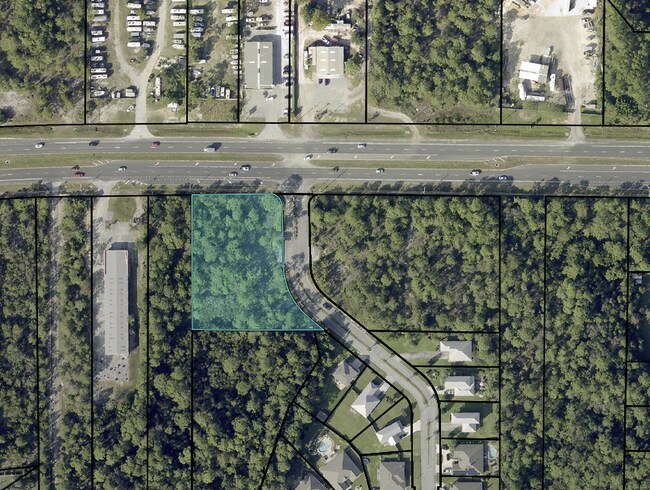
Gulf Breeze Pkwy, Gulf Breeze, FL 32563

NEARBY LISTINGS FOR SALE OR LEASE
Property Detail
Gulf Breeze Pkwy
Pensacola-Ferry Pass-Brent, FL
**REDESCRIBED IN 2025 ** 20-2S-27W: BEG AT NE COR LT 1 BLK C SUMMERSET ESTATES, THN N88*0506W 293.28FT , THN N01*1002E 288.01FT , THN S88*0322E 174.96FT , THN S44*0300E 34.74FT CHD ALNG CRV R=25.00FT, THN S00*2631E 124.40FT , THN S25*0024E 124.75FT C
20-2S-27-0000-02700-0000
Santa Rosa
Commercialacreage
Florida
X
1
12113C0563H
1.32 AC
2024
Navarre
2025
Pensacola
010814
DEMOGRAPHICS near Gulf Breeze Pkwy
1 Mile
3 Mile
5 Mile
2024 Total Population
4,953
19,959
39,402
2029 Population
5,818
23,178
45,601
Pop Growth 2024-2029
+ 17.46%
+ 16.13%
+ 15.73%
Average Age
40
40
40
2024 Total Households
1,915
7,458
14,962
HH Growth 2024-2029
+ 17.75%
+ 16.52%
+ 16.16%
Median Household Inc
$83,753
$92,474
$94,037
Avg Household Size
2.60
2.70
2.60
2024 Avg HH Vehicles
2.00
2.00
2.00
Median Home Value
$301,077
$320,784
$325,658
Median Year Built
2006
2005
2003
Nearby Places
Map Layers
Map Styles
 Street
 Aerial
- Restaurants
- Banks
- Shops
- Fitness
- Groceries
PUBLIC TRANSPORTATION
AIRPORT
Pensacola International
DRIVE
WALK
Distance
Pensacola International
43 min
23.6 mi
Eglin AFB/Destin-Ft Walton Beach
DRIVE
WALK
Distance
Eglin AFB/Destin-Ft Walton Beach
62 min
32.8 mi
Freight Ports
Port of Mobile
DRIVE
WALK
Distance
Port of Mobile
96 min
79.5 mi
SALE & LEASE HISTORY
LISTING DATE
SALE/LEASE

Oct 25, 2023
For Sale
Apr 25, 2023
For Lease
Nearby Properties
Address
Land Use
TOTAL SIZE
Lot Size
Zoning
Address
Land Use
TOTAL SIZE
Lot Size
Zoning
1.03 AC
NONE
Address
Land Use
TOTAL SIZE
Lot Size
Zoning
242,842 SF
14.77 AC
PBD
Address
Land Use
TOTAL SIZE
Lot Size
Zoning
241,693 SF
14.28 AC
PBD
Address
Land Use
TOTAL SIZE
Lot Size
Zoning
36,404 SF
100.31 AC
PBD
Address
Land Use
TOTAL SIZE
Lot Size
Zoning
161,438 SF
5.64 AC
HCD
Address
Land Use
TOTAL SIZE
Lot Size
Zoning
116,452 SF
4.55 AC
HCD
Address
Land Use
TOTAL SIZE
Lot Size
Zoning
51,677 SF
17.79 AC
PBD
Address
Land Use
TOTAL SIZE
Lot Size
Zoning
91,391 SF
4.28 AC
PBD
Address
Land Use
TOTAL SIZE
Lot Size
Zoning
130,030 SF
36.74 AC
R1A
Address
Land Use
TOTAL SIZE
Lot Size
Zoning
54,123 SF
6.05 AC
PBD
Address
Land Use
TOTAL SIZE
Lot Size
Zoning
62,068 SF
4.64 AC
M1
Address
Land Use
TOTAL SIZE
Lot Size
Zoning
73,433 SF
33.98 AC
HCD
Address
Land Use
TOTAL SIZE
Lot Size
Zoning
24,565 SF
17.03 AC
HCD
Address
Land Use
TOTAL SIZE
Lot Size
Zoning
45,438 SF
4.85 AC
HCD
Address
Land Use
TOTAL SIZE
Lot Size
Zoning
20,488 SF
14.34 AC
PBD
Address
Land Use
TOTAL SIZE
Lot Size
Zoning
25.10 AC
HCD
Address
Land Use
TOTAL SIZE
Lot Size
Zoning
62,960 SF
4.59 AC
HCD
Address
Land Use
TOTAL SIZE
Lot Size
Zoning
31,699 SF
4.39 AC
HCD
Address
Land Use
TOTAL SIZE
Lot Size
Zoning
48,285 SF
2.62 AC
HCD
Address
Land Use
TOTAL SIZE
Lot Size
Zoning
40,963 SF
8.36 AC
HCD
Address
Land Use
TOTAL SIZE
Lot Size
Zoning
22,042 SF
4.17 AC
HCD
Address
Land Use
TOTAL SIZE
Lot Size
Zoning
20.66 AC
PBD
Address
Land Use
TOTAL SIZE
Lot Size
Zoning
19.59 AC
HCD
Address
Land Use
TOTAL SIZE
Lot Size
Zoning
21,254 SF
13.88 AC
R2
Address
Land Use
TOTAL SIZE
Lot Size
Zoning
20,150 SF
4.02 AC
HCD
The World's #1 Commercial Real Estate Marketplace
Connect with us
© 2026 CoStar Group
The information above has been obtained from sources believed reliable. While we do not doubt its accuracy we have not verified it and make no guarantee, warranty or representation about it. It is your responsibility to independently confirm its accuracy and completeness. Any projections, opinions, assumptions, or estimates used are for example only and do not represent the current or future performance of the property. The value of this transaction to you depends on tax and other factors which should be evaluated by your tax, financial, and legal advisors. You and your advisors should conduct a careful, independent investigation of the property to determine to your satisfaction the suitability of the property for your needs.