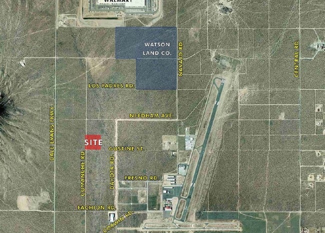
Property Record
Gustine St, Apple Valley, CA 92307
Property Detail
Gustine St
Riverside-San Bernardino-Ontario, CA
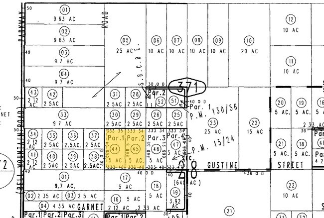
PARCEL MAP 1731 PARCEL 2 EX CO RD
0463-371-44
SAN BERNARDINO
Vacantlandnec
California
D Areas with possible but undetermined flood hazards.
4.38 AC
2025
Mojave River Valley
2025
Inland Empire (California)
009714
NEARBY LISTINGS FOR SALE OR LEASE
DEMOGRAPHICS near Gustine St
1 mile
3 mile
5 mile
2025 Total Population
11
7,600
31,729
2030 Population
11
7,840
32,227
Pop Growth 2025-2030
0.00%
+ 3.16%
+ 1.57%
Average Age
40
38
38
2025 Total Households
4
2,530
10,499
HH Growth 2025-2030
0.00%
+ 3.24%
+ 1.61%
Median Household Inc
$93,749
$68,322
$75,317
Avg Household Size
2.40
3.00
3.00
2025 Avg HH Vehicles
3.00
2.00
2.00
Median Home Value
$499,999
$428,655
$443,103
Median Year Built
1989
1988
1985
Nearby Places
Map Layers
Map Styles
 Street
 Aerial
Transit
 Traffic
 Biking
Places
Listings with unknown addresses are not visible on the map
- Restaurants
- Banks
- Shops
- Fitness
- Groceries
PUBLIC TRANSPORTATION
COMMUTER RAIL
Victorville Amtrak (Southwest Chief - Amtrak)
Drive
Walk
Distance
Victorville Amtrak (Southwest Chief - Amtrak)
15 min
7.0 mi
Freight Ports
Port of Long Beach
Drive
Walk
Distance
Port of Long Beach
131 min
105.9 mi
Nearby Properties
Address
Land Use
TOTAL SIZE
Lot Size
Zoning
Address
Land Use
TOTAL SIZE
Lot Size
Zoning
1,345,009 SF
106.46 AC
Address
Land Use
TOTAL SIZE
Lot Size
Zoning
1,096,308 SF
225.42 AC
Address
Land Use
TOTAL SIZE
Lot Size
Zoning
145,600 SF
10.43 AC
Address
Land Use
TOTAL SIZE
Lot Size
Zoning
67.89 AC
Address
Land Use
TOTAL SIZE
Lot Size
Zoning
Address
Land Use
TOTAL SIZE
Lot Size
Zoning
39.10 AC
Address
Land Use
TOTAL SIZE
Lot Size
Zoning
143.55 AC
IR
Address
Land Use
TOTAL SIZE
Lot Size
Zoning
610 AC
Address
Land Use
TOTAL SIZE
Lot Size
Zoning
120 AC
RL
Address
Land Use
TOTAL SIZE
Lot Size
Zoning
40 AC
RL
Address
Land Use
TOTAL SIZE
Lot Size
Zoning
40 AC
RL
Address
Land Use
TOTAL SIZE
Lot Size
Zoning
35.63 AC
Address
Land Use
TOTAL SIZE
Lot Size
Zoning
35.60 AC
Address
Land Use
TOTAL SIZE
Lot Size
Zoning
35.11 AC
Address
Land Use
TOTAL SIZE
Lot Size
Zoning
35.08 AC
Address
Land Use
TOTAL SIZE
Lot Size
Zoning
47.68 AC
Address
Land Use
TOTAL SIZE
Lot Size
Zoning
30,573 SF
2.91 AC
Address
Land Use
TOTAL SIZE
Lot Size
Zoning
Address
Land Use
TOTAL SIZE
Lot Size
Zoning
Address
Land Use
TOTAL SIZE
Lot Size
Zoning
20.42 AC
Address
Land Use
TOTAL SIZE
Lot Size
Zoning
Address
Land Use
TOTAL SIZE
Lot Size
Zoning
3,080 SF
1.87 AC
Address
Land Use
TOTAL SIZE
Lot Size
Zoning
80 AC
RL
Address
Land Use
TOTAL SIZE
Lot Size
Zoning
72.06 AC
Address
Land Use
TOTAL SIZE
Lot Size
Zoning
29,615 SF
3.27 AC
Address
Land Use
TOTAL SIZE
Lot Size
Zoning
Address
Land Use
TOTAL SIZE
Lot Size
Zoning
17.87 AC
Address
Land Use
TOTAL SIZE
Lot Size
Zoning
68.61 AC
RL
Address
Land Use
TOTAL SIZE
Lot Size
Zoning
41.10 AC
The World's #1 Commercial Real Estate Marketplace
Connect with us
© 2026 CoStar Group
The information above has been obtained from sources believed reliable. While we do not doubt its accuracy we have not verified it and make no guarantee, warranty or representation about it. It is your responsibility to independently confirm its accuracy and completeness. Any projections, opinions, assumptions, or estimates used are for example only and do not represent the current or future performance of the property. The value of this transaction to you depends on tax and other factors which should be evaluated by your tax, financial, and legal advisors. You and your advisors should conduct a careful, independent investigation of the property to determine to your satisfaction the suitability of the property for your needs.