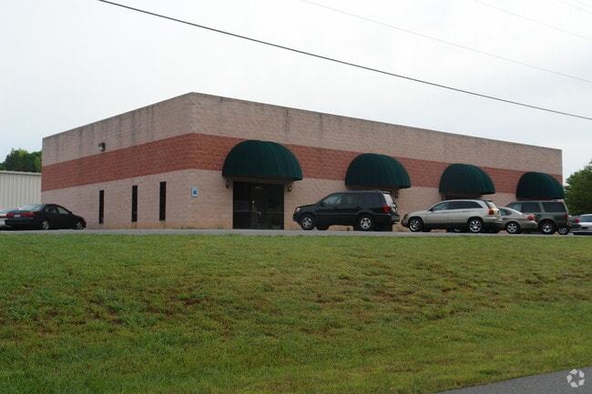
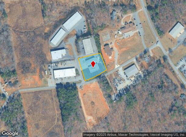
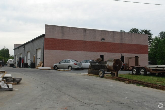
Property Record
Hagers Hollow Dr, Denver, NC 28037
Current Lease Availabilities
NEARBY LISTINGS FOR SALE OR LEASE
Property Detail
Hagers Hollow Dr
Charlotte-Concord-Gastonia, NC-SC
Hugers Hollow
34131
#1 HAGERS HOLLOW
Multipleuses
Lincoln
2025
North Carolina
2025
1.22 AC
071101
Lincoln County
6,060 SF
Charlotte
DEMOGRAPHICS near Hagers Hollow Dr
1 Mile
3 Mile
5 Mile
2024 Total Population
2,789
21,225
41,444
2029 Population
3,364
25,180
48,352
Pop Growth 2024-2029
+ 20.62%
+ 18.63%
+ 16.67%
Average Age
40
42
44
2024 Total Households
1,049
8,253
16,297
HH Growth 2024-2029
+ 20.78%
+ 18.83%
+ 16.84%
Median Household Inc
$107,744
$108,149
$105,815
Avg Household Size
2.70
2.60
2.50
2024 Avg HH Vehicles
2.00
2.00
2.00
Median Home Value
$431,338
$459,489
$463,070
Median Year Built
2009
2002
2002
Nearby Places
Map Layers
Map Styles
 Street
 Aerial
- Restaurants
- Banks
- Shops
- Fitness
- Groceries
PUBLIC TRANSPORTATION
AIRPORT
Charlotte/Douglas International
DRIVE
WALK
Distance
Charlotte/Douglas International
44 min
24.7 mi
Concord-Padgett Regional
DRIVE
WALK
Distance
Concord-Padgett Regional
41 min
26.4 mi
Freight Ports
North Charleston Terminal
DRIVE
WALK
Distance
North Charleston Terminal
254 min
220.5 mi
Nearby Properties
Address
Land Use
TOTAL SIZE
Lot Size
Zoning
Address
Land Use
TOTAL SIZE
Lot Size
Zoning
897,320 SF
109.51 AC
I-G
Address
Land Use
TOTAL SIZE
Lot Size
Zoning
23,112 SF
11.70 AC
ELDD PD-MU
Address
Land Use
TOTAL SIZE
Lot Size
Zoning
56,780 SF
30.55 AC
B-G
Address
Land Use
TOTAL SIZE
Lot Size
Zoning
201,670 SF
20.06 AC
I-G
Address
Land Use
TOTAL SIZE
Lot Size
Zoning
52,732 SF
17.01 AC
ELDD R-SF
Address
Land Use
TOTAL SIZE
Lot Size
Zoning
91,753 SF
19.94 AC
R-T
Address
Land Use
TOTAL SIZE
Lot Size
Zoning
6,264 SF
24.64 AC
ELDD B-G
Address
Land Use
TOTAL SIZE
Lot Size
Zoning
66,136 SF
18.10 AC
ELDD B-N &
Address
Land Use
TOTAL SIZE
Lot Size
Zoning
9,827 SF
13.35 AC
ELDD R-SF
Address
Land Use
TOTAL SIZE
Lot Size
Zoning
7,800 SF
4.49 AC
ELDD B-G C
Address
Land Use
TOTAL SIZE
Lot Size
Zoning
115,200 SF
20.31 AC
I-G
Address
Land Use
TOTAL SIZE
Lot Size
Zoning
251,009 SF
20.46 AC
ELDD I-G
Address
Land Use
TOTAL SIZE
Lot Size
Zoning
42,185 SF
5.26 AC
B-G
Address
Land Use
TOTAL SIZE
Lot Size
Zoning
12,948 SF
28.37 AC
R-SF
Address
Land Use
TOTAL SIZE
Lot Size
Zoning
32,163 SF
48.72 AC
ELDD R-T
Address
Land Use
TOTAL SIZE
Lot Size
Zoning
120,500 SF
12.50 AC
ELDD I-G
Address
Land Use
TOTAL SIZE
Lot Size
Zoning
17,443 SF
19.66 AC
B-G
Address
Land Use
TOTAL SIZE
Lot Size
Zoning
81,228 SF
26.89 AC
ELDD B-N C
Address
Land Use
TOTAL SIZE
Lot Size
Zoning
87,700 SF
7.53 AC
I-G
Address
Land Use
TOTAL SIZE
Lot Size
Zoning
17,978 SF
39.55 AC
R-T
Address
Land Use
TOTAL SIZE
Lot Size
Zoning
601.08 AC
R-T
Address
Land Use
TOTAL SIZE
Lot Size
Zoning
8,100 SF
275.67 AC
PD-R CU
Address
Land Use
TOTAL SIZE
Lot Size
Zoning
20,923 SF
2.83 AC
R-S CU
Address
Land Use
TOTAL SIZE
Lot Size
Zoning
7,059 SF
5.32 AC
R-SF
Address
Land Use
TOTAL SIZE
Lot Size
Zoning
44,606 SF
4.49 AC
ELDD PD-I
Address
Land Use
TOTAL SIZE
Lot Size
Zoning
45,326 SF
4.45 AC
ELDD B-G
Address
Land Use
TOTAL SIZE
Lot Size
Zoning
12,000 SF
7.87 AC
ELDD B-G C
Address
Land Use
TOTAL SIZE
Lot Size
Zoning
14,854 SF
16.71 AC
ELDD R-S &
Address
Land Use
TOTAL SIZE
Lot Size
Zoning
12,500 SF
2.53 AC
ELDD B-G
Address
Land Use
TOTAL SIZE
Lot Size
Zoning
19,952 SF
2.24 AC
ELDD B-N
The World's #1 Commercial Real Estate Marketplace
Connect with us
© 2025 CoStar Group
The information above has been obtained from sources believed reliable. While we do not doubt its accuracy we have not verified it and make no guarantee, warranty or representation about it. It is your responsibility to independently confirm its accuracy and completeness. Any projections, opinions, assumptions, or estimates used are for example only and do not represent the current or future performance of the property. The value of this transaction to you depends on tax and other factors which should be evaluated by your tax, financial, and legal advisors. You and your advisors should conduct a careful, independent investigation of the property to determine to your satisfaction the suitability of the property for your needs.