Property Record
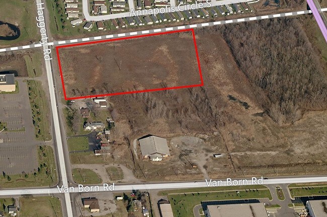
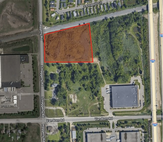
Haggerty Rd S, Canton, MI 48188

This Property Is For Sale
Property Detail
Haggerty Rd S
Detroit-Warren-Dearborn, MI
36HH3 THAT PART OF THE SW 1/4 OF SEC 36 DESCRIBED AS BEGINNING AT A POINT ON THE W LINE OF SAID SEC- TION DISTANT DUE NORTH 691.37 FT FROM THE SW CORNER OF SEC 36 AND PROCEEDING TH DUE NORTH ALONG SAID LINE 345.46 FT TH N 79D 24M 35SEC E ALONG THE SL
71-143-99-0018-000
WAYNE
Industrialacreage
Michigan
LI-1
0018
B and X Area of moderate flood hazard, usually the area between the limits of the 100-year and 500-year floods.
6.19 AC
2025
Airport District
2025
Detroit
564800
NEARBY LISTINGS FOR SALE OR LEASE
DEMOGRAPHICS near Haggerty Rd S
1 mile
3 mile
5 mile
2025 Total Population
2,329
48,987
150,831
2030 Population
2,288
47,944
148,300
Pop Growth 2025-2030
(1.76%)
(2.13%)
(1.68%)
Average Age
33
40
41
2025 Total Households
826
18,800
60,333
HH Growth 2025-2030
(1.82%)
(2.18%)
(1.70%)
Median Household Inc
$51,087
$91,293
$83,048
Avg Household Size
2.70
2.60
2.40
2025 Avg HH Vehicles
1.00
2.00
2.00
Median Home Value
$62,499
$262,551
$254,860
Median Year Built
1995
1985
1977
Nearby Places
Map Layers
Map Styles
 Street
 Aerial
Layers
 Traffic
 Biking
Places
Listings with unknown addresses are not visible on the map
- Restaurants
- Banks
- Shops
- Fitness
- Groceries
PUBLIC TRANSPORTATION
AIRPORT
Detroit Metro Wayne County
Drive
Walk
Distance
Detroit Metro Wayne County
19 min
11.0 mi
Windsor International
Drive
Walk
Distance
Windsor International
57 min
35.3 mi
Freight Ports
Drive
Walk
Distance
64 min
51.4 mi
Nearby Properties
Address
Land Use
TOTAL SIZE
Lot Size
Zoning
Address
Land Use
TOTAL SIZE
Lot Size
Zoning
739,289 SF
238.69 AC
AG
Address
Land Use
TOTAL SIZE
Lot Size
Zoning
347,606 SF
71.56 AC
M2 GEN
Address
Land Use
TOTAL SIZE
Lot Size
Zoning
919,978 SF
65.96 AC
MT IND
Address
Land Use
TOTAL SIZE
Lot Size
Zoning
39.50 AC
MR
Address
Land Use
TOTAL SIZE
Lot Size
Zoning
495,062 SF
52.40 AC
M1 LIG
Address
Land Use
TOTAL SIZE
Lot Size
Zoning
387,834 SF
71.56 AC
M2 GEN
Address
Land Use
TOTAL SIZE
Lot Size
Zoning
393,948 SF
43.43 AC
M2-GEN
Address
Land Use
TOTAL SIZE
Lot Size
Zoning
435,648 SF
27.84 AC
M2-GEN
Address
Land Use
TOTAL SIZE
Lot Size
Zoning
1,182 SF
25.21 AC
G-1
Address
Land Use
TOTAL SIZE
Lot Size
Zoning
1,071,200 SF
85.27 AC
M1 LIG
Address
Land Use
TOTAL SIZE
Lot Size
Zoning
685,104 SF
44.25 AC
M1 LIG
Address
Land Use
TOTAL SIZE
Lot Size
Zoning
1,789,755 SF
138.32 AC
IND-2 HVY
Address
Land Use
TOTAL SIZE
Lot Size
Zoning
136,775 SF
15.54 AC
C-3
Address
Land Use
TOTAL SIZE
Lot Size
Zoning
20.91 AC
Address
Land Use
TOTAL SIZE
Lot Size
Zoning
920,139 SF
56.56 AC
M2-GEN
Address
Land Use
TOTAL SIZE
Lot Size
Zoning
285,080 SF
21.89 AC
M2-GEN
Address
Land Use
TOTAL SIZE
Lot Size
Zoning
169,489 SF
14.51 AC
R-6
Address
Land Use
TOTAL SIZE
Lot Size
Zoning
206,896 SF
19.49 AC
R-6
Address
Land Use
TOTAL SIZE
Lot Size
Zoning
190,344 SF
18.24 AC
R-6
Address
Land Use
TOTAL SIZE
Lot Size
Zoning
443,082 SF
30.01 AC
LI-2
Address
Land Use
TOTAL SIZE
Lot Size
Zoning
489,500 SF
58.51 AC
M2-GEN
Address
Land Use
TOTAL SIZE
Lot Size
Zoning
240,355 SF
26.05 AC
M2-GEN
Address
Land Use
TOTAL SIZE
Lot Size
Zoning
5,382 SF
109.33 AC
RMH-MOB
Address
Land Use
TOTAL SIZE
Lot Size
Zoning
169,968 SF
12.46 AC
MR
Address
Land Use
TOTAL SIZE
Lot Size
Zoning
630,828 SF
62.51 AC
R1B
Address
Land Use
TOTAL SIZE
Lot Size
Zoning
1,619,168 SF
150.49 AC
M2-GEN
Address
Land Use
TOTAL SIZE
Lot Size
Zoning
659,516 SF
46.15 AC
MT IND
Address
Land Use
TOTAL SIZE
Lot Size
Zoning
437,836 SF
28.75 AC
M1 LIG
Address
Land Use
TOTAL SIZE
Lot Size
Zoning
147,968 SF
16.68 AC
Address
Land Use
TOTAL SIZE
Lot Size
Zoning
199,952 SF
13.06 AC
The World's #1 Commercial Real Estate Marketplace
Connect with us
© 2026 CoStar Group
The information above has been obtained from sources believed reliable. While we do not doubt its accuracy we have not verified it and make no guarantee, warranty or representation about it. It is your responsibility to independently confirm its accuracy and completeness. Any projections, opinions, assumptions, or estimates used are for example only and do not represent the current or future performance of the property. The value of this transaction to you depends on tax and other factors which should be evaluated by your tax, financial, and legal advisors. You and your advisors should conduct a careful, independent investigation of the property to determine to your satisfaction the suitability of the property for your needs.