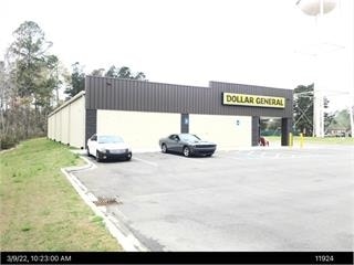
Property Record
383 Halcyondale Rd, Sylvania, GA 30467
Property Detail
383 Halcyondale Rd
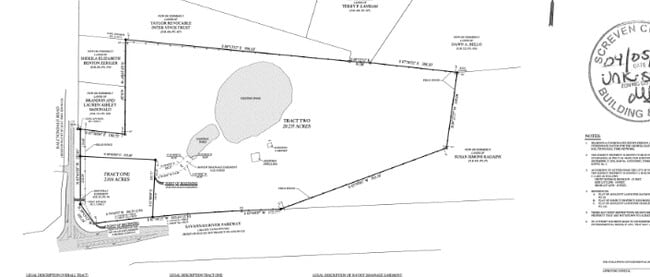
082-046-A
2.02 AC DOLLAR GENERAL HALCYONDALE ROAD
Wholesaleoutletdiscountstore
SCREVEN
004
Georgia
2025
2.02 AC
2025
Georgia South Area
970401
Other Market Areas
10,512 SF
NEARBY LISTINGS FOR SALE OR LEASE
DEMOGRAPHICS near 383 Halcyondale Rd
1 mile
3 mile
5 mile
2025 Total Population
1,285
4,165
6,008
2030 Population
1,306
4,186
6,038
Pop Growth 2025-2030
+ 1.63%
+ 0.50%
+ 0.50%
Average Age
43
42
42
2025 Total Households
539
1,710
2,435
HH Growth 2025-2030
+ 1.48%
+ 0.18%
+ 0.12%
Median Household Inc
$38,737
$38,620
$39,906
Avg Household Size
2.40
2.40
2.40
2025 Avg HH Vehicles
2.00
2.00
2.00
Median Home Value
$128,151
$128,906
$141,148
Median Year Built
1971
1972
1975
Nearby Places
Map Layers
Map Styles
 Street
 Aerial
Layers
 Traffic
 Biking
Places
Listings with unknown addresses are not visible on the map
- Restaurants
- Banks
- Shops
- Fitness
- Groceries
SALE & LEASE HISTORY
LISTING DATE
SALE/LEASE

Oct 18, 2024
For Sale
Nearby Properties
Address
Land Use
TOTAL SIZE
Lot Size
Zoning
Address
Land Use
TOTAL SIZE
Lot Size
Zoning
48.85 AC
007
Address
Land Use
TOTAL SIZE
Lot Size
Zoning
6,000 SF
18.02 AC
002
Address
Land Use
TOTAL SIZE
Lot Size
Zoning
39.21 AC
002
Address
Land Use
TOTAL SIZE
Lot Size
Zoning
50.13 AC
005
Address
Land Use
TOTAL SIZE
Lot Size
Zoning
424,887 SF
55.26 AC
003
Address
Land Use
TOTAL SIZE
Lot Size
Zoning
15,330 SF
12.87 AC
002
Address
Land Use
TOTAL SIZE
Lot Size
Zoning
209,692 SF
86.90 AC
007
Address
Land Use
TOTAL SIZE
Lot Size
Zoning
5,570 SF
9.07 AC
002
Address
Land Use
TOTAL SIZE
Lot Size
Zoning
25,000 SF
2.73 AC
005
Address
Land Use
TOTAL SIZE
Lot Size
Zoning
45,391 SF
8.05 AC
002
Address
Land Use
TOTAL SIZE
Lot Size
Zoning
560 SF
923.39 AC
004
Address
Land Use
TOTAL SIZE
Lot Size
Zoning
17,591 SF
2.46 AC
002
Address
Land Use
TOTAL SIZE
Lot Size
Zoning
55,426 SF
6.81 AC
002
Address
Land Use
TOTAL SIZE
Lot Size
Zoning
36,766 SF
4.91 AC
002
Address
Land Use
TOTAL SIZE
Lot Size
Zoning
36,288 SF
11.64 AC
002
Address
Land Use
TOTAL SIZE
Lot Size
Zoning
1,848 SF
9.35 AC
007
Address
Land Use
TOTAL SIZE
Lot Size
Zoning
4,800 SF
8.61 AC
005
Address
Land Use
TOTAL SIZE
Lot Size
Zoning
464.31 AC
004
Address
Land Use
TOTAL SIZE
Lot Size
Zoning
13,500 SF
1 AC
007
Address
Land Use
TOTAL SIZE
Lot Size
Zoning
25,880 SF
3.86 AC
002
Address
Land Use
TOTAL SIZE
Lot Size
Zoning
443 AC
004
Address
Land Use
TOTAL SIZE
Lot Size
Zoning
1,500 SF
4.27 AC
002
Address
Land Use
TOTAL SIZE
Lot Size
Zoning
25,875 SF
8.87 AC
005
Address
Land Use
TOTAL SIZE
Lot Size
Zoning
1,750 SF
253.61 AC
004
Address
Land Use
TOTAL SIZE
Lot Size
Zoning
35,000 SF
50.65 AC
003
Address
Land Use
TOTAL SIZE
Lot Size
Zoning
13,680 SF
2 AC
005
Address
Land Use
TOTAL SIZE
Lot Size
Zoning
311.55 AC
007
Address
Land Use
TOTAL SIZE
Lot Size
Zoning
5,000 SF
3.61 AC
004
Address
Land Use
TOTAL SIZE
Lot Size
Zoning
252.63 AC
004
Address
Land Use
TOTAL SIZE
Lot Size
Zoning
11,080 SF
1.11 AC
002
The World's #1 Commercial Real Estate Marketplace
Connect with us
© 2026 CoStar Group
The information above has been obtained from sources believed reliable. While we do not doubt its accuracy we have not verified it and make no guarantee, warranty or representation about it. It is your responsibility to independently confirm its accuracy and completeness. Any projections, opinions, assumptions, or estimates used are for example only and do not represent the current or future performance of the property. The value of this transaction to you depends on tax and other factors which should be evaluated by your tax, financial, and legal advisors. You and your advisors should conduct a careful, independent investigation of the property to determine to your satisfaction the suitability of the property for your needs.