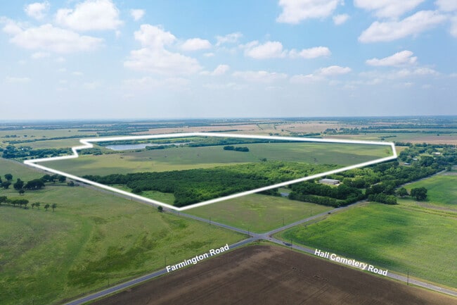
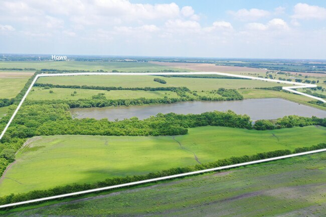
Property Record
Hall Cemetary Rd, Howe, TX 75459

Property Detail
Hall Cemetary Rd
Sherman-Denison, TX
G-0534 HILLIS J M A-G0534, ACRES 146.9820
130869
GRAYSON
Farms
Texas
B and X Area of moderate flood hazard, usually the area between the limits of the 100-year and 500-year floods.
146.98 AC
2024
Howe
2025
Other Market Areas
001801
NEARBY LISTINGS FOR SALE OR LEASE
DEMOGRAPHICS near Hall Cemetary Rd
1 mile
3 mile
5 mile
2025 Total Population
33
4,588
7,951
2030 Population
36
5,025
8,746
Pop Growth 2025-2030
+ 9.09%
+ 9.52%
+ 10.00%
Average Age
40
36
38
2025 Total Households
12
1,638
2,792
HH Growth 2025-2030
+ 8.33%
+ 9.65%
+ 10.14%
Median Household Inc
$124,999
$66,774
$103,420
Avg Household Size
2.60
2.70
2.80
2025 Avg HH Vehicles
2.00
2.00
2.00
Median Home Value
$399,999
$327,347
$390,745
Median Year Built
2010
1991
2000
Nearby Places
Map Layers
Map Styles
 Street
 Aerial
Transit
 Traffic
 Biking
Places
Listings with unknown addresses are not visible on the map
- Restaurants
- Banks
- Shops
- Fitness
- Groceries
SALE & LEASE HISTORY
LISTING DATE
SALE/LEASE

Jul 19, 2021
For Sale
Jul 06, 2021
For Sale
Nearby Properties
Address
Land Use
TOTAL SIZE
Lot Size
Zoning
Address
Land Use
TOTAL SIZE
Lot Size
Zoning
50,488 SF
10 AC
Address
Land Use
TOTAL SIZE
Lot Size
Zoning
100,748 SF
13 AC
Address
Land Use
TOTAL SIZE
Lot Size
Zoning
3,952 SF
20.18 AC
Address
Land Use
TOTAL SIZE
Lot Size
Zoning
87,400 SF
8.72 AC
Address
Land Use
TOTAL SIZE
Lot Size
Zoning
61,966 SF
5.06 AC
Address
Land Use
TOTAL SIZE
Lot Size
Zoning
101,664 SF
20.93 AC
Address
Land Use
TOTAL SIZE
Lot Size
Zoning
40,404 SF
3.05 AC
Address
Land Use
TOTAL SIZE
Lot Size
Zoning
10,917 SF
5.60 AC
Address
Land Use
TOTAL SIZE
Lot Size
Zoning
30,704 SF
38.87 AC
Address
Land Use
TOTAL SIZE
Lot Size
Zoning
41,600 SF
5.30 AC
Address
Land Use
TOTAL SIZE
Lot Size
Zoning
41,600 SF
9.03 AC
Address
Land Use
TOTAL SIZE
Lot Size
Zoning
27,000 SF
3.73 AC
Address
Land Use
TOTAL SIZE
Lot Size
Zoning
7,647 SF
79.22 AC
Address
Land Use
TOTAL SIZE
Lot Size
Zoning
6,516 SF
0.73 AC
Address
Land Use
TOTAL SIZE
Lot Size
Zoning
9,020 SF
1.01 AC
Address
Land Use
TOTAL SIZE
Lot Size
Zoning
17.73 AC
Address
Land Use
TOTAL SIZE
Lot Size
Zoning
12,980 SF
0.92 AC
Address
Land Use
TOTAL SIZE
Lot Size
Zoning
28,564 SF
1.79 AC
Address
Land Use
TOTAL SIZE
Lot Size
Zoning
24.08 AC
Address
Land Use
TOTAL SIZE
Lot Size
Zoning
24,732 SF
3.60 AC
Address
Land Use
TOTAL SIZE
Lot Size
Zoning
6,864 SF
0.61 AC
Address
Land Use
TOTAL SIZE
Lot Size
Zoning
29,948 SF
5.92 AC
Address
Land Use
TOTAL SIZE
Lot Size
Zoning
5 AC
Address
Land Use
TOTAL SIZE
Lot Size
Zoning
20.18 AC
Address
Land Use
TOTAL SIZE
Lot Size
Zoning
19,440 SF
1.57 AC
Address
Land Use
TOTAL SIZE
Lot Size
Zoning
5,591 SF
70.43 AC
Address
Land Use
TOTAL SIZE
Lot Size
Zoning
17,936 SF
2.66 AC
Address
Land Use
TOTAL SIZE
Lot Size
Zoning
4,090 SF
22 AC
Address
Land Use
TOTAL SIZE
Lot Size
Zoning
4,532 SF
11.52 AC
Address
Land Use
TOTAL SIZE
Lot Size
Zoning
3,992 SF
2.03 AC
The World's #1 Commercial Real Estate Marketplace
Connect with us
© 2026 CoStar Group
The information above has been obtained from sources believed reliable. While we do not doubt its accuracy we have not verified it and make no guarantee, warranty or representation about it. It is your responsibility to independently confirm its accuracy and completeness. Any projections, opinions, assumptions, or estimates used are for example only and do not represent the current or future performance of the property. The value of this transaction to you depends on tax and other factors which should be evaluated by your tax, financial, and legal advisors. You and your advisors should conduct a careful, independent investigation of the property to determine to your satisfaction the suitability of the property for your needs.