Property Record
Hamilton Ave, Billings, MT 59101
NEARBY LISTINGS FOR SALE OR LEASE
Property Detail
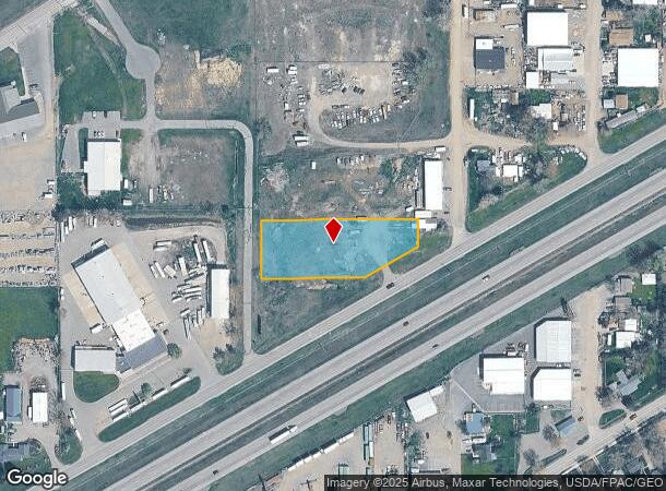
Hamilton Ave
Billings, MT
Sanford Subd
03-1033-25-3-16-03-0000
SANFORD SUBD, S25, T01 N, R26 E, BLOCK 3, LOT 6A, AMND LT 1-12 BLK 4 & LT 2-11 BLK 3
Commercialacreage
Yellowstone
X
Montana
30111C1290E
6a
2024
1.19 AC
2025
Billings
000902
Other Market Areas
DEMOGRAPHICS near Hamilton Ave
1 Mile
3 Mile
5 Mile
2024 Total Population
1,718
29,591
67,851
2029 Population
1,838
31,961
73,245
Pop Growth 2024-2029
+ 6.98%
+ 8.01%
+ 7.95%
Average Age
41
39
39
2024 Total Households
695
11,812
27,688
HH Growth 2024-2029
+ 7.05%
+ 8.20%
+ 8.09%
Median Household Inc
$51,118
$65,438
$64,744
Avg Household Size
2.40
2.40
2.30
2024 Avg HH Vehicles
2.00
2.00
2.00
Median Home Value
$192,788
$261,326
$274,972
Median Year Built
1972
1984
1976
Nearby Places
Map Layers
Map Styles
 Street
 Aerial
- Restaurants
- Banks
- Shops
- Fitness
- Groceries
PUBLIC TRANSPORTATION
AIRPORT
Billings Logan International
DRIVE
WALK
Distance
Billings Logan International
26 min
9.1 mi
Freight Ports
Port of Everett
DRIVE
WALK
Distance
Port of Everett
890 min
845.8 mi
SALE & LEASE HISTORY
LISTING DATE
SALE/LEASE

Oct 05, 2018
For Sale
Nov 16, 2016
For Sale
Apr 05, 2017
For Sale
Nearby Properties
Address
Land Use
TOTAL SIZE
Lot Size
Zoning
Address
Land Use
TOTAL SIZE
Lot Size
Zoning
240,253 SF
282.66 AC
HI
Address
Land Use
TOTAL SIZE
Lot Size
Zoning
6,000 SF
152.47 AC
PUBLIC-COU
Address
Land Use
TOTAL SIZE
Lot Size
Zoning
117,130 SF
29.86 AC
R-70
Address
Land Use
TOTAL SIZE
Lot Size
Zoning
181,007 SF
19.57 AC
Address
Land Use
TOTAL SIZE
Lot Size
Zoning
60.42 AC
HI
Address
Land Use
TOTAL SIZE
Lot Size
Zoning
68,022 SF
4.01 AC
CI
Address
Land Use
TOTAL SIZE
Lot Size
Zoning
53.34 AC
P
Address
Land Use
TOTAL SIZE
Lot Size
Zoning
57,112 SF
7.69 AC
Address
Land Use
TOTAL SIZE
Lot Size
Zoning
25,045 SF
10.77 AC
R-70
Address
Land Use
TOTAL SIZE
Lot Size
Zoning
43.08 AC
R-96
Address
Land Use
TOTAL SIZE
Lot Size
Zoning
41.37 AC
P
Address
Land Use
TOTAL SIZE
Lot Size
Zoning
72,949 SF
4.12 AC
HC
Address
Land Use
TOTAL SIZE
Lot Size
Zoning
128,015 SF
17.89 AC
CI
Address
Land Use
TOTAL SIZE
Lot Size
Zoning
42,704 SF
8.56 AC
R-70
Address
Land Use
TOTAL SIZE
Lot Size
Zoning
60,615 SF
4.25 AC
R-70
Address
Land Use
TOTAL SIZE
Lot Size
Zoning
30,098 SF
HI
Address
Land Use
TOTAL SIZE
Lot Size
Zoning
20,266 SF
3.91 AC
RMF
Address
Land Use
TOTAL SIZE
Lot Size
Zoning
21,162 SF
3.83 AC
RMF
Address
Land Use
TOTAL SIZE
Lot Size
Zoning
125,591 SF
12 AC
HC
Address
Land Use
TOTAL SIZE
Lot Size
Zoning
104,596 SF
10.32 AC
HI
Address
Land Use
TOTAL SIZE
Lot Size
Zoning
22,574 SF
23.53 AC
CI
Address
Land Use
TOTAL SIZE
Lot Size
Zoning
65,662 SF
41.39 AC
Address
Land Use
TOTAL SIZE
Lot Size
Zoning
42.39 AC
RMH
Address
Land Use
TOTAL SIZE
Lot Size
Zoning
4,939 SF
36.28 AC
RMH
Address
Land Use
TOTAL SIZE
Lot Size
Zoning
40,026 SF
2.40 AC
RMF
Address
Land Use
TOTAL SIZE
Lot Size
Zoning
14,292 SF
2.91 AC
MF
Address
Land Use
TOTAL SIZE
Lot Size
Zoning
11,120 SF
39.02 AC
RMH
Address
Land Use
TOTAL SIZE
Lot Size
Zoning
24,126 SF
2.52 AC
Address
Land Use
TOTAL SIZE
Lot Size
Zoning
45,856 SF
6.55 AC
RMF
Address
Land Use
TOTAL SIZE
Lot Size
Zoning
15.36 AC
P
The World's #1 Commercial Real Estate Marketplace
Connect with us
© 2025 CoStar Group
The information above has been obtained from sources believed reliable. While we do not doubt its accuracy we have not verified it and make no guarantee, warranty or representation about it. It is your responsibility to independently confirm its accuracy and completeness. Any projections, opinions, assumptions, or estimates used are for example only and do not represent the current or future performance of the property. The value of this transaction to you depends on tax and other factors which should be evaluated by your tax, financial, and legal advisors. You and your advisors should conduct a careful, independent investigation of the property to determine to your satisfaction the suitability of the property for your needs.