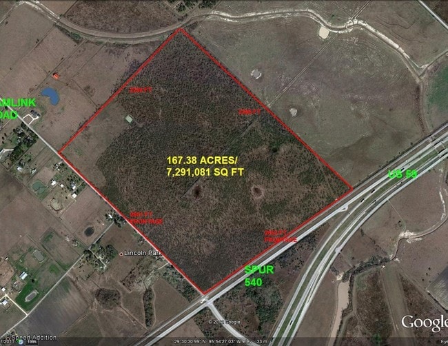
Property Record
610 Hamlink Rd, Rosenberg, TX 77471

NEARBY LISTINGS FOR SALE OR LEASE
Property Detail
610 Hamlink Rd
Houston-The Woodlands-Sugar Land, TX
L E Cross Sec 16
0384-00-039-0003-901
0384 L E CROSS SEC 16, ACRES 53.444, (PT) NOT IN CITY OF ROSENBERG
Ranch
Fort Bend
A
Texas
48157C0225L
53.44 AC
2024
Southwest Outlier
2025
Houston
675300
DEMOGRAPHICS near 610 Hamlink Rd
1 Mile
3 Mile
5 Mile
2024 Total Population
598
2,197
5,210
2029 Population
718
2,624
6,198
Pop Growth 2024-2029
+ 20.07%
+ 19.44%
+ 18.96%
Average Age
36
38
38
2024 Total Households
187
701
1,691
HH Growth 2024-2029
+ 20.86%
+ 19.83%
+ 19.52%
Median Household Inc
$66,521
$66,835
$65,938
Avg Household Size
3.20
3.10
3.10
2024 Avg HH Vehicles
2.00
2.00
2.00
Median Home Value
$128,333
$166,499
$234,156
Median Year Built
1984
1984
1984
Nearby Places
Map Layers
Map Styles
 Street
 Aerial
- Restaurants
- Banks
- Shops
- Fitness
- Groceries
SALE & LEASE HISTORY
LISTING DATE
SALE/LEASE

Sep 24, 2016
For Sale
Jun 10, 2025
For Sale
Nearby Properties
Address
Land Use
TOTAL SIZE
Lot Size
Zoning
Address
Land Use
TOTAL SIZE
Lot Size
Zoning
100,000 SF
1.32 AC
Address
Land Use
TOTAL SIZE
Lot Size
Zoning
208.52 AC
OST
Address
Land Use
TOTAL SIZE
Lot Size
Zoning
194.64 AC
Address
Land Use
TOTAL SIZE
Lot Size
Zoning
129.15 AC
Address
Land Use
TOTAL SIZE
Lot Size
Zoning
2,064 SF
93.87 AC
QO
Address
Land Use
TOTAL SIZE
Lot Size
Zoning
75.19 AC
Address
Land Use
TOTAL SIZE
Lot Size
Zoning
110,714 SF
14.34 AC
Address
Land Use
TOTAL SIZE
Lot Size
Zoning
159.79 AC
OTYM
Address
Land Use
TOTAL SIZE
Lot Size
Zoning
21.35 AC
S
Address
Land Use
TOTAL SIZE
Lot Size
Zoning
Address
Land Use
TOTAL SIZE
Lot Size
Zoning
33,106 SF
6 AC
J
Address
Land Use
TOTAL SIZE
Lot Size
Zoning
13,200 SF
2.20 AC
S
Address
Land Use
TOTAL SIZE
Lot Size
Zoning
13,920 SF
3 AC
SM
Address
Land Use
TOTAL SIZE
Lot Size
Zoning
28,690 SF
4.01 AC
J
Address
Land Use
TOTAL SIZE
Lot Size
Zoning
47,860 SF
4 AC
YS
Address
Land Use
TOTAL SIZE
Lot Size
Zoning
72.55 AC
Address
Land Use
TOTAL SIZE
Lot Size
Zoning
44,400 SF
70.82 AC
O
Address
Land Use
TOTAL SIZE
Lot Size
Zoning
41,500 SF
5 AC
Address
Land Use
TOTAL SIZE
Lot Size
Zoning
800 SF
89.75 AC
OTS
Address
Land Use
TOTAL SIZE
Lot Size
Zoning
13,280 SF
17.10 AC
YZ
Address
Land Use
TOTAL SIZE
Lot Size
Zoning
45 AC
QY
Address
Land Use
TOTAL SIZE
Lot Size
Zoning
6,891 SF
4.01 AC
XY
Address
Land Use
TOTAL SIZE
Lot Size
Zoning
11,820 SF
2.57 AC
MY
Address
Land Use
TOTAL SIZE
Lot Size
Zoning
85.37 AC
Y
Address
Land Use
TOTAL SIZE
Lot Size
Zoning
21,190 SF
10 AC
ST
Address
Land Use
TOTAL SIZE
Lot Size
Zoning
2,910 SF
1 AC
Address
Land Use
TOTAL SIZE
Lot Size
Zoning
58.43 AC
SYO
Address
Land Use
TOTAL SIZE
Lot Size
Zoning
784 SF
1.67 AC
X
Address
Land Use
TOTAL SIZE
Lot Size
Zoning
1,097 SF
18.77 AC
YQ
Address
Land Use
TOTAL SIZE
Lot Size
Zoning
68.80 AC
The World's #1 Commercial Real Estate Marketplace
Connect with us
© 2025 CoStar Group
The information above has been obtained from sources believed reliable. While we do not doubt its accuracy we have not verified it and make no guarantee, warranty or representation about it. It is your responsibility to independently confirm its accuracy and completeness. Any projections, opinions, assumptions, or estimates used are for example only and do not represent the current or future performance of the property. The value of this transaction to you depends on tax and other factors which should be evaluated by your tax, financial, and legal advisors. You and your advisors should conduct a careful, independent investigation of the property to determine to your satisfaction the suitability of the property for your needs.