Property Record
Hanger, Roanoke, TX 76262
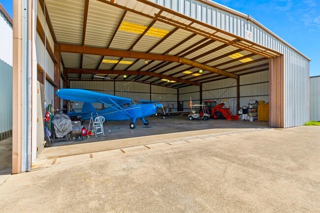


Property Detail
Hanger
R98742
A1128A G RAMSDALE, TR 15, .18 ACRES, OLD DCAD TR #85
Commercialnec
DENTON
B and X Area of moderate flood hazard, usually the area between the limits of the 100-year and 500-year floods.
Texas
2024
0.18 AC
2025
Alliance
020311
Dallas/Ft Worth
3,600 SF
Dallas-Fort Worth-Arlington, TX
NEARBY LISTINGS FOR SALE OR LEASE
-
-
View all Roanoke listings for sale on LoopNet.com
DEMOGRAPHICS near Hanger
1 mile
3 mile
5 mile
2025 Total Population
769
20,429
70,051
2030 Population
882
23,492
80,322
Pop Growth 2025-2030
+ 14.69%
+ 14.99%
+ 14.66%
Average Age
37
38
38
2025 Total Households
248
7,050
23,803
HH Growth 2025-2030
+ 15.32%
+ 15.26%
+ 14.94%
Median Household Inc
$179,411
$132,765
$139,935
Avg Household Size
3.10
2.90
2.90
2025 Avg HH Vehicles
2.00
2.00
2.00
Median Home Value
$537,402
$597,539
$605,570
Median Year Built
2011
2010
2010
Nearby Places
Map Layers
Map Styles
 Street
 Aerial
Layers
 Traffic
 Biking
Places
Listings with unknown addresses are not visible on the map
- Restaurants
- Banks
- Shops
- Fitness
- Groceries
PUBLIC TRANSPORTATION
AIRPORT
Dallas-Fort Worth International
Drive
Walk
Distance
Dallas-Fort Worth International
35 min
23.0 mi
Dallas Love Field
Drive
Walk
Distance
Dallas Love Field
53 min
36.8 mi
SALE & LEASE HISTORY
LISTING DATE
SALE/LEASE

Oct 12, 2025
For Sale
Nearby Properties
Address
Land Use
TOTAL SIZE
Lot Size
Zoning
Address
Land Use
TOTAL SIZE
Lot Size
Zoning
9,800 SF
1,266.35 AC
Address
Land Use
TOTAL SIZE
Lot Size
Zoning
414,274 SF
15.73 AC
Address
Land Use
TOTAL SIZE
Lot Size
Zoning
413,316 SF
22.96 AC
Address
Land Use
TOTAL SIZE
Lot Size
Zoning
470,000 SF
11.91 AC
Address
Land Use
TOTAL SIZE
Lot Size
Zoning
495,170 SF
14.02 AC
Address
Land Use
TOTAL SIZE
Lot Size
Zoning
1,217,200 SF
56.35 AC
Address
Land Use
TOTAL SIZE
Lot Size
Zoning
984,910 SF
83.90 AC
Address
Land Use
TOTAL SIZE
Lot Size
Zoning
301,718 SF
18.12 AC
10 G
Address
Land Use
TOTAL SIZE
Lot Size
Zoning
542,880 SF
28.13 AC
Address
Land Use
TOTAL SIZE
Lot Size
Zoning
1,049,614 SF
47.33 AC
Address
Land Use
TOTAL SIZE
Lot Size
Zoning
371,473 SF
82.85 AC
Address
Land Use
TOTAL SIZE
Lot Size
Zoning
667,152 SF
34.50 AC
Address
Land Use
TOTAL SIZE
Lot Size
Zoning
406,860 SF
10.54 AC
Address
Land Use
TOTAL SIZE
Lot Size
Zoning
569,365 SF
68.61 AC
Address
Land Use
TOTAL SIZE
Lot Size
Zoning
639,877 SF
29.59 AC
Address
Land Use
TOTAL SIZE
Lot Size
Zoning
104,812 SF
16.10 AC
Address
Land Use
TOTAL SIZE
Lot Size
Zoning
539,775 SF
28 AC
Address
Land Use
TOTAL SIZE
Lot Size
Zoning
498,960 SF
34.03 AC
Address
Land Use
TOTAL SIZE
Lot Size
Zoning
505,134 SF
25.40 AC
Address
Land Use
TOTAL SIZE
Lot Size
Zoning
461,930 SF
30.31 AC
Address
Land Use
TOTAL SIZE
Lot Size
Zoning
154,000 SF
106.92 AC
Address
Land Use
TOTAL SIZE
Lot Size
Zoning
405,105 SF
34.61 AC
Address
Land Use
TOTAL SIZE
Lot Size
Zoning
211,500 SF
15 AC
Address
Land Use
TOTAL SIZE
Lot Size
Zoning
354,730 SF
20.03 AC
Address
Land Use
TOTAL SIZE
Lot Size
Zoning
134,098 SF
10.59 AC
Address
Land Use
TOTAL SIZE
Lot Size
Zoning
110.30 AC
Address
Land Use
TOTAL SIZE
Lot Size
Zoning
227,500 SF
16.37 AC
Address
Land Use
TOTAL SIZE
Lot Size
Zoning
224,640 SF
15.04 AC
Address
Land Use
TOTAL SIZE
Lot Size
Zoning
18,000 SF
142.51 AC
Address
Land Use
TOTAL SIZE
Lot Size
Zoning
202,748 SF
10.61 AC
The World's #1 Commercial Real Estate Marketplace
Connect with us
© 2026 CoStar Group
The information above has been obtained from sources believed reliable. While we do not doubt its accuracy we have not verified it and make no guarantee, warranty or representation about it. It is your responsibility to independently confirm its accuracy and completeness. Any projections, opinions, assumptions, or estimates used are for example only and do not represent the current or future performance of the property. The value of this transaction to you depends on tax and other factors which should be evaluated by your tax, financial, and legal advisors. You and your advisors should conduct a careful, independent investigation of the property to determine to your satisfaction the suitability of the property for your needs.