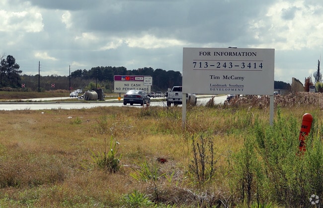
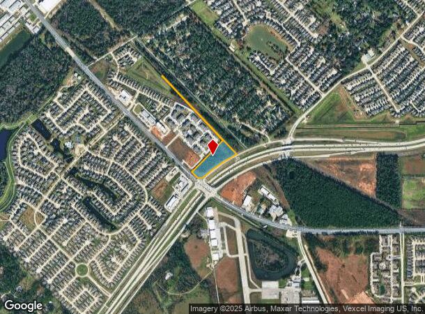
Property Record
0 Fm 2920, Tomball, TX 77375
NEARBY LISTINGS FOR SALE OR LEASE
Property Detail
0 Fm 2920
Houston-The Woodlands-Sugar Land, TX
Abst 70 E Smith
0410260010428
TR 46B ABST 70 E SMITH
Commercialacreage
Harris
X
Texas
48201C0235M
6.56 AC
2024
The Woodlands
2025
Houston
554803
DEMOGRAPHICS near 0 Fm 2920
1 Mile
3 Mile
5 Mile
2024 Total Population
8,810
66,885
203,930
2029 Population
9,161
68,826
209,049
Pop Growth 2024-2029
+ 3.98%
+ 2.90%
+ 2.51%
Average Age
33
35
37
2024 Total Households
2,621
21,621
67,863
HH Growth 2024-2029
+ 3.97%
+ 2.88%
+ 2.49%
Median Household Inc
$88,343
$100,161
$101,077
Avg Household Size
3.30
3.00
2.90
2024 Avg HH Vehicles
2.00
2.00
2.00
Median Home Value
$259,382
$285,815
$284,521
Median Year Built
2007
2008
2004
Nearby Places
- Restaurants
- Banks
- Shops
- Fitness
- Groceries
PUBLIC TRANSPORTATION
AIRPORT
George Bush Intcntl/Houston
DRIVE
WALK
Distance
George Bush Intcntl/Houston
29 min
24.5 mi
Freight Ports
Port of Houston
DRIVE
WALK
Distance
Port of Houston
52 min
40.2 mi
SALE & LEASE HISTORY
LISTING DATE
SALE/LEASE

Feb 19, 2018
For Lease
Dec 13, 2018
For Sale
Nearby Properties
Address
Land Use
TOTAL SIZE
Lot Size
Zoning
Address
Land Use
TOTAL SIZE
Lot Size
Zoning
379,180 SF
15.52 AC
Address
Land Use
TOTAL SIZE
Lot Size
Zoning
156,885 SF
26.24 AC
Address
Land Use
TOTAL SIZE
Lot Size
Zoning
341,895 SF
17.53 AC
Address
Land Use
TOTAL SIZE
Lot Size
Zoning
398,856 SF
12.76 AC
Address
Land Use
TOTAL SIZE
Lot Size
Zoning
375,293 SF
19.29 AC
Address
Land Use
TOTAL SIZE
Lot Size
Zoning
335,258 SF
12.18 AC
Address
Land Use
TOTAL SIZE
Lot Size
Zoning
328,692 SF
18.47 AC
Address
Land Use
TOTAL SIZE
Lot Size
Zoning
322,733 SF
18.40 AC
Address
Land Use
TOTAL SIZE
Lot Size
Zoning
332,688 SF
24.57 AC
Address
Land Use
TOTAL SIZE
Lot Size
Zoning
294,931 SF
10.94 AC
Address
Land Use
TOTAL SIZE
Lot Size
Zoning
306,815 SF
14.88 AC
Address
Land Use
TOTAL SIZE
Lot Size
Zoning
249,950 SF
15.92 AC
Address
Land Use
TOTAL SIZE
Lot Size
Zoning
267,082 SF
11.13 AC
Address
Land Use
TOTAL SIZE
Lot Size
Zoning
393,751 SF
17.08 AC
Address
Land Use
TOTAL SIZE
Lot Size
Zoning
241,113 SF
6.29 AC
Address
Land Use
TOTAL SIZE
Lot Size
Zoning
451,840 SF
44.47 AC
Address
Land Use
TOTAL SIZE
Lot Size
Zoning
207,662 SF
11.32 AC
Address
Land Use
TOTAL SIZE
Lot Size
Zoning
253,800 SF
43.72 AC
Address
Land Use
TOTAL SIZE
Lot Size
Zoning
219,000 SF
46.59 AC
Address
Land Use
TOTAL SIZE
Lot Size
Zoning
233,293 SF
13.20 AC
Address
Land Use
TOTAL SIZE
Lot Size
Zoning
123,937 SF
5.52 AC
Address
Land Use
TOTAL SIZE
Lot Size
Zoning
155,960 SF
25.96 AC
Address
Land Use
TOTAL SIZE
Lot Size
Zoning
214,862 SF
14.92 AC
Address
Land Use
TOTAL SIZE
Lot Size
Zoning
106,618 SF
12.48 AC
Address
Land Use
TOTAL SIZE
Lot Size
Zoning
224,669 SF
15.40 AC
Address
Land Use
TOTAL SIZE
Lot Size
Zoning
96,300 SF
21.59 AC
Address
Land Use
TOTAL SIZE
Lot Size
Zoning
120,220 SF
13.49 AC
Address
Land Use
TOTAL SIZE
Lot Size
Zoning
211,876 SF
21.78 AC
Address
Land Use
TOTAL SIZE
Lot Size
Zoning
202,728 SF
3.50 AC
The World's #1 Commercial Real Estate Marketplace
Connect with us
© 2025 CoStar Group
The information above has been obtained from sources believed reliable. While we do not doubt its accuracy we have not verified it and make no guarantee, warranty or representation about it. It is your responsibility to independently confirm its accuracy and completeness. Any projections, opinions, assumptions, or estimates used are for example only and do not represent the current or future performance of the property. The value of this transaction to you depends on tax and other factors which should be evaluated by your tax, financial, and legal advisors. You and your advisors should conduct a careful, independent investigation of the property to determine to your satisfaction the suitability of the property for your needs.