Property Record
Harden Bridge Rd, Commerce, GA 30529
Save to a Folder
{{folder.Name}}
{{folder.ListingIds.length}} Properties
{{folder.ListingIds.length}} Property
Create a New Folder
Property Detail
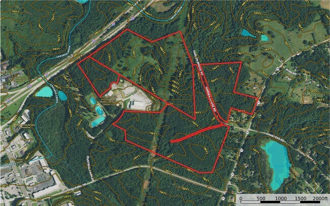
Harden Bridge Rd
B66-040
NO RECORD
Agriculturalland
BANKS
ARR
Georgia
A Areas with a 1% annual chance of flooding and a 26% chance of flooding over the life of a 30-year mortgage.
26.59 AC
2025
Athens/Gainesville
2025
Other Market Areas
970400
NEARBY LISTINGS FOR SALE OR LEASE
DEMOGRAPHICS near Harden Bridge Rd
1 mile
3 mile
5 mile
2025 Total Population
354
6,648
16,180
2030 Population
391
7,683
18,736
Pop Growth 2025-2030
+ 10.45%
+ 15.57%
+ 15.80%
Average Age
41
39
40
2025 Total Households
124
2,382
6,029
HH Growth 2025-2030
+ 9.68%
+ 15.66%
+ 15.94%
Median Household Inc
$49,062
$78,832
$71,767
Avg Household Size
2.70
2.70
2.60
2025 Avg HH Vehicles
2.00
2.00
2.00
Median Home Value
$246,296
$274,672
$291,062
Median Year Built
1993
1995
1990
Nearby Places
Map Layers
Map Styles
 Street
 Aerial
Layers
 Traffic
 Biking
Places
Listings with unknown addresses are not visible on the map
- Restaurants
- Banks
- Shops
- Fitness
- Groceries
SALE & LEASE HISTORY
LISTING DATE
SALE/LEASE

Jan 24, 2022
For Sale
Nearby Properties
Address
Land Use
TOTAL SIZE
Lot Size
Zoning
Address
Land Use
TOTAL SIZE
Lot Size
Zoning
47,853 SF
15.93 AC
R2
Address
Land Use
TOTAL SIZE
Lot Size
Zoning
192,721 SF
22.14 AC
M1
Address
Land Use
TOTAL SIZE
Lot Size
Zoning
962,280 SF
74.52 AC
MI
Address
Land Use
TOTAL SIZE
Lot Size
Zoning
52,325 SF
36.96 AC
HRC
Address
Land Use
TOTAL SIZE
Lot Size
Zoning
206,500 SF
14.39 AC
001
Address
Land Use
TOTAL SIZE
Lot Size
Zoning
170,100 SF
11.51 AC
001
Address
Land Use
TOTAL SIZE
Lot Size
Zoning
126,216 SF
14.49 AC
E1
Address
Land Use
TOTAL SIZE
Lot Size
Zoning
91,226 SF
40 AC
M1
Address
Land Use
TOTAL SIZE
Lot Size
Zoning
17,197 SF
318.04 AC
C2
Address
Land Use
TOTAL SIZE
Lot Size
Zoning
101,750 SF
17.02 AC
C2
Address
Land Use
TOTAL SIZE
Lot Size
Zoning
151,192 SF
27.32 AC
C2
Address
Land Use
TOTAL SIZE
Lot Size
Zoning
38 AC
AR
Address
Land Use
TOTAL SIZE
Lot Size
Zoning
95,761 SF
30.97 AC
M1
Address
Land Use
TOTAL SIZE
Lot Size
Zoning
150,400 SF
13.91 AC
004
Address
Land Use
TOTAL SIZE
Lot Size
Zoning
12,065 SF
2.09 AC
C2
Address
Land Use
TOTAL SIZE
Lot Size
Zoning
7,980 SF
15 AC
002
Address
Land Use
TOTAL SIZE
Lot Size
Zoning
104,932 SF
23.60 AC
C2
Address
Land Use
TOTAL SIZE
Lot Size
Zoning
51,478 SF
1.52 AC
C2
Address
Land Use
TOTAL SIZE
Lot Size
Zoning
12,238 SF
1.73 AC
C2
Address
Land Use
TOTAL SIZE
Lot Size
Zoning
93.38 AC
GI
Address
Land Use
TOTAL SIZE
Lot Size
Zoning
13,398 SF
15 AC
B2
Address
Land Use
TOTAL SIZE
Lot Size
Zoning
80,000 SF
21.47 AC
C2
Address
Land Use
TOTAL SIZE
Lot Size
Zoning
114,246 SF
15.02 AC
C2
Address
Land Use
TOTAL SIZE
Lot Size
Zoning
95,761 SF
30.97 AC
M1
Address
Land Use
TOTAL SIZE
Lot Size
Zoning
12,872 SF
1.61 AC
C2
Address
Land Use
TOTAL SIZE
Lot Size
Zoning
4,072 SF
5.12 AC
C2
Address
Land Use
TOTAL SIZE
Lot Size
Zoning
3,600 SF
68.12 AC
C2
Address
Land Use
TOTAL SIZE
Lot Size
Zoning
15,971 SF
7.79 AC
C2
Address
Land Use
TOTAL SIZE
Lot Size
Zoning
78.40 AC
C2
Address
Land Use
TOTAL SIZE
Lot Size
Zoning
44.49 AC
C2
The World's #1 Commercial Real Estate Marketplace
Connect with us
© 2026 CoStar Group
The information above has been obtained from sources believed reliable. While we do not doubt its accuracy we have not verified it and make no guarantee, warranty or representation about it. It is your responsibility to independently confirm its accuracy and completeness. Any projections, opinions, assumptions, or estimates used are for example only and do not represent the current or future performance of the property. The value of this transaction to you depends on tax and other factors which should be evaluated by your tax, financial, and legal advisors. You and your advisors should conduct a careful, independent investigation of the property to determine to your satisfaction the suitability of the property for your needs.