Property Record
Harding Rd, Springfield, OH 45504

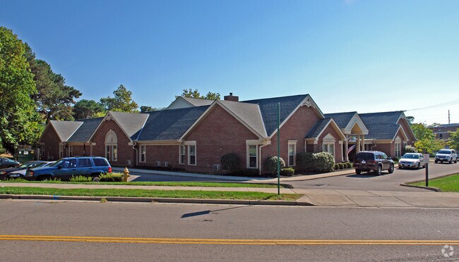

Property Detail
Harding Rd
Springfield, OH
N E COR ST PARIS PIKE & HARDING ROAD
34-00600-00640-2003
CLARK
Retirementnursinghomecombined
Ohio
B and X Area of moderate flood hazard, usually the area between the limits of the 100-year and 500-year floods.
3
2024
0.23 AC
2025
Northeast Dayton
001900
Cincinnati/Dayton
11,516 SF
NEARBY LISTINGS FOR SALE OR LEASE
-
-
View all Springfield listings for sale on LoopNet.com
DEMOGRAPHICS near Harding Rd
1 mile
3 mile
5 mile
2024 Total Population
6,775
53,507
87,071
2029 Population
6,698
53,923
87,268
Pop Growth 2024-2029
(1.14%)
+ 0.78%
+ 0.23%
Average Age
41
40
41
2024 Total Households
2,865
22,095
36,332
HH Growth 2024-2029
(1.08%)
+ 0.73%
+ 0.20%
Median Household Inc
$67,401
$47,390
$52,340
Avg Household Size
2.20
2.30
2.30
2024 Avg HH Vehicles
2.00
2.00
2.00
Median Home Value
$202,111
$144,103
$157,587
Median Year Built
1949
1952
1958
Nearby Places
Map Layers
Map Styles
 Street
 Aerial
Transit
 Traffic
 Biking
Places
Listings with unknown addresses are not visible on the map
- Restaurants
- Banks
- Shops
- Fitness
- Groceries
PUBLIC TRANSPORTATION
AIRPORT
James M Cox Dayton International
Drive
Walk
Distance
James M Cox Dayton International
35 min
27.0 mi
Freight Ports
Port of Toledo
Drive
Walk
Distance
Port of Toledo
186 min
130.7 mi
Nearby Properties
Address
Land Use
TOTAL SIZE
Lot Size
Zoning
Address
Land Use
TOTAL SIZE
Lot Size
Zoning
1.20 AC
Address
Land Use
TOTAL SIZE
Lot Size
Zoning
479,515 SF
1.69 AC
Address
Land Use
TOTAL SIZE
Lot Size
Zoning
399,308 SF
11.06 AC
Address
Land Use
TOTAL SIZE
Lot Size
Zoning
32.89 AC
Address
Land Use
TOTAL SIZE
Lot Size
Zoning
107.87 AC
Address
Land Use
TOTAL SIZE
Lot Size
Zoning
17,280 SF
14.32 AC
Address
Land Use
TOTAL SIZE
Lot Size
Zoning
Address
Land Use
TOTAL SIZE
Lot Size
Zoning
234,478 SF
59.28 AC
Address
Land Use
TOTAL SIZE
Lot Size
Zoning
193,701 SF
16.31 AC
Address
Land Use
TOTAL SIZE
Lot Size
Zoning
103,458 SF
5.51 AC
Address
Land Use
TOTAL SIZE
Lot Size
Zoning
399,308 SF
11.06 AC
Address
Land Use
TOTAL SIZE
Lot Size
Zoning
61,376 SF
3.95 AC
Address
Land Use
TOTAL SIZE
Lot Size
Zoning
160,352 SF
22.89 AC
Address
Land Use
TOTAL SIZE
Lot Size
Zoning
25.44 AC
Address
Land Use
TOTAL SIZE
Lot Size
Zoning
1,582 SF
42.13 AC
Address
Land Use
TOTAL SIZE
Lot Size
Zoning
47,929 SF
2.77 AC
Address
Land Use
TOTAL SIZE
Lot Size
Zoning
Address
Land Use
TOTAL SIZE
Lot Size
Zoning
225,335 SF
22.73 AC
Address
Land Use
TOTAL SIZE
Lot Size
Zoning
103,589 SF
59.28 AC
Address
Land Use
TOTAL SIZE
Lot Size
Zoning
218,901 SF
19.15 AC
Address
Land Use
TOTAL SIZE
Lot Size
Zoning
136,700 SF
14.37 AC
Address
Land Use
TOTAL SIZE
Lot Size
Zoning
56,381 SF
2.37 AC
Address
Land Use
TOTAL SIZE
Lot Size
Zoning
6,521 SF
94.30 AC
Address
Land Use
TOTAL SIZE
Lot Size
Zoning
Address
Land Use
TOTAL SIZE
Lot Size
Zoning
Address
Land Use
TOTAL SIZE
Lot Size
Zoning
32,566 SF
1.90 AC
Address
Land Use
TOTAL SIZE
Lot Size
Zoning
79,187 SF
7.70 AC
Address
Land Use
TOTAL SIZE
Lot Size
Zoning
111,936 SF
7.04 AC
Address
Land Use
TOTAL SIZE
Lot Size
Zoning
399,308 SF
31.78 AC
Address
Land Use
TOTAL SIZE
Lot Size
Zoning
1.05 AC
The World's #1 Commercial Real Estate Marketplace
Connect with us
© 2026 CoStar Group
The information above has been obtained from sources believed reliable. While we do not doubt its accuracy we have not verified it and make no guarantee, warranty or representation about it. It is your responsibility to independently confirm its accuracy and completeness. Any projections, opinions, assumptions, or estimates used are for example only and do not represent the current or future performance of the property. The value of this transaction to you depends on tax and other factors which should be evaluated by your tax, financial, and legal advisors. You and your advisors should conduct a careful, independent investigation of the property to determine to your satisfaction the suitability of the property for your needs.