Property Record
B S Hard Scrabble Rd, Columbia, SC 29229
NEARBY LISTINGS FOR SALE OR LEASE
Property Detail
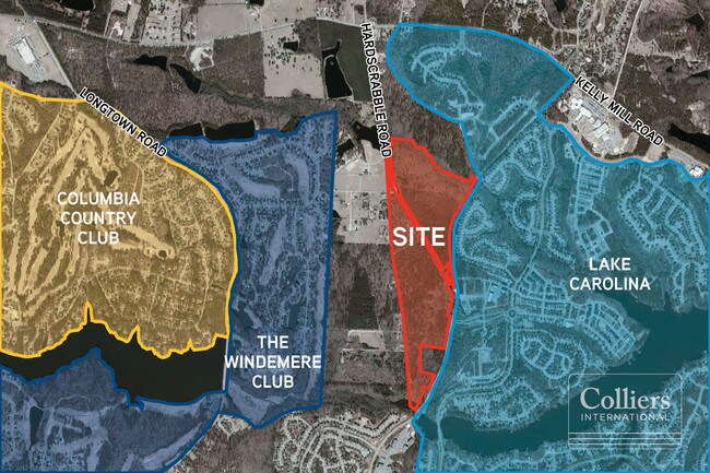
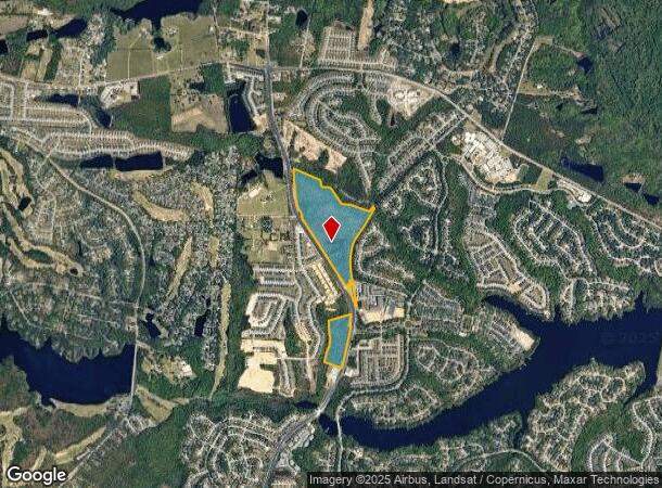
B S Hard Scrabble Rd
Columbia, SC
The Falls
20400-01-13
#SU #PR 50-655 RB1294-3249
Agriculturalland
Richland
X
South Carolina
45079C0142L
62.90 AC
2025
Northeast Columbia
2024
Columbia
011417
DEMOGRAPHICS near B S Hard Scrabble Rd
1 Mile
3 Mile
5 Mile
2024 Total Population
7,645
48,496
88,287
2029 Population
7,838
49,169
89,884
Pop Growth 2024-2029
+ 2.52%
+ 1.39%
+ 1.81%
Average Age
36
37
37
2024 Total Households
2,654
17,305
32,711
HH Growth 2024-2029
+ 2.45%
+ 1.36%
+ 1.87%
Median Household Inc
$82,735
$77,071
$73,038
Avg Household Size
2.80
2.80
2.70
2024 Avg HH Vehicles
2.00
2.00
2.00
Median Home Value
$279,881
$220,820
$215,622
Median Year Built
2007
2004
2003
Nearby Places
Map Layers
Map Styles
 Street
 Aerial
- Restaurants
- Banks
- Shops
- Fitness
- Groceries
PUBLIC TRANSPORTATION
AIRPORT
Columbia Metro
DRIVE
WALK
Distance
Columbia Metro
50 min
28.7 mi
Freight Ports
North Charleston Terminal
DRIVE
WALK
Distance
North Charleston Terminal
149 min
125.8 mi
SALE & LEASE HISTORY
LISTING DATE
SALE/LEASE

Sep 24, 2016
For Sale
Sep 24, 2016
For Sale
Jun 26, 2017
For Sale
Jun 21, 2017
For Sale
Jun 21, 2017
For Sale
Feb 06, 2017
For Sale
Feb 06, 2017
For Sale
Apr 27, 2017
For Sale
Apr 27, 2017
For Sale
Nearby Properties
Address
Land Use
TOTAL SIZE
Lot Size
Zoning
Address
Land Use
TOTAL SIZE
Lot Size
Zoning
309,478 SF
8.87 AC
PDD
Address
Land Use
TOTAL SIZE
Lot Size
Zoning
232,148 SF
14.16 AC
PDD
Address
Land Use
TOTAL SIZE
Lot Size
Zoning
143,072 SF
12.61 AC
PDD
Address
Land Use
TOTAL SIZE
Lot Size
Zoning
125,894 SF
7.77 AC
PDD
Address
Land Use
TOTAL SIZE
Lot Size
Zoning
73,901 SF
8.83 AC
PUD
Address
Land Use
TOTAL SIZE
Lot Size
Zoning
117,832 SF
10.82 AC
PDD
Address
Land Use
TOTAL SIZE
Lot Size
Zoning
74,014 SF
22.02 AC
HI
Address
Land Use
TOTAL SIZE
Lot Size
Zoning
2,574 SF
5.83 AC
GC
Address
Land Use
TOTAL SIZE
Lot Size
Zoning
44.55 AC
PDD
Address
Land Use
TOTAL SIZE
Lot Size
Zoning
75,250 SF
4.12 AC
PDD
Address
Land Use
TOTAL SIZE
Lot Size
Zoning
69,202 SF
11.98 AC
PDD
Address
Land Use
TOTAL SIZE
Lot Size
Zoning
54,254 SF
6.83 AC
PDD
Address
Land Use
TOTAL SIZE
Lot Size
Zoning
14,720 SF
2.07 AC
PDD
Address
Land Use
TOTAL SIZE
Lot Size
Zoning
2,474 SF
104.46 AC
RU
Address
Land Use
TOTAL SIZE
Lot Size
Zoning
31,934 SF
289.15 AC
TROS
Address
Land Use
TOTAL SIZE
Lot Size
Zoning
73,947 SF
2.32 AC
PDD
Address
Land Use
TOTAL SIZE
Lot Size
Zoning
10,706 SF
1.51 AC
GC
Address
Land Use
TOTAL SIZE
Lot Size
Zoning
8,728 SF
7.36 AC
RU
Address
Land Use
TOTAL SIZE
Lot Size
Zoning
29,857 SF
5.64 AC
PDD
Address
Land Use
TOTAL SIZE
Lot Size
Zoning
12,670 SF
9.47 AC
OI
Address
Land Use
TOTAL SIZE
Lot Size
Zoning
20.94 AC
PDD
Address
Land Use
TOTAL SIZE
Lot Size
Zoning
3,015 SF
7.42 AC
PDD
Address
Land Use
TOTAL SIZE
Lot Size
Zoning
17,336 SF
3.08 AC
GC
Address
Land Use
TOTAL SIZE
Lot Size
Zoning
7,842 SF
2.37 AC
GC
Address
Land Use
TOTAL SIZE
Lot Size
Zoning
10,966 SF
1.22 AC
PDD
Address
Land Use
TOTAL SIZE
Lot Size
Zoning
3,206 SF
0.88 AC
GC
Address
Land Use
TOTAL SIZE
Lot Size
Zoning
10,421 SF
6.64 AC
PDD
Address
Land Use
TOTAL SIZE
Lot Size
Zoning
6,846 SF
7.88 AC
PDD
Address
Land Use
TOTAL SIZE
Lot Size
Zoning
5.73 AC
RU
Address
Land Use
TOTAL SIZE
Lot Size
Zoning
7,848 SF
1.27 AC
GC
The World's #1 Commercial Real Estate Marketplace
Connect with us
© 2025 CoStar Group
The information above has been obtained from sources believed reliable. While we do not doubt its accuracy we have not verified it and make no guarantee, warranty or representation about it. It is your responsibility to independently confirm its accuracy and completeness. Any projections, opinions, assumptions, or estimates used are for example only and do not represent the current or future performance of the property. The value of this transaction to you depends on tax and other factors which should be evaluated by your tax, financial, and legal advisors. You and your advisors should conduct a careful, independent investigation of the property to determine to your satisfaction the suitability of the property for your needs.