Property Record
Harlan Lewis Rd, Bellevue, NE 68123
NEARBY LISTINGS FOR SALE OR LEASE
Property Detail
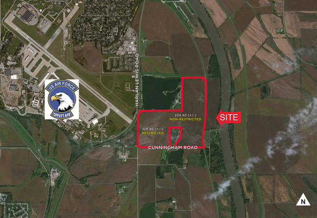
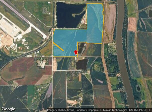
Harlan Lewis Rd
Omaha-Council Bluffs, NE-IA
South/Drainage Ditch
011040416
THAT PT TAX LOT 14 & PT OF TAX LOT 11 LYING SOUTH OF DRAINAGE DITCH & WEST OF LEVEE EXC PT FOR NRD 7-13-14 (292.4 AC)
Agriculturalland
Sarpy
AH
Nebraska
31025C0125D
14,11
2024
292.40 AC
2025
Southeast Omaha
010106
Omaha/Council Bluffs
DEMOGRAPHICS near Harlan Lewis Rd
1 Mile
3 Mile
5 Mile
2024 Total Population
14
12,586
51,522
2029 Population
15
13,559
55,463
Pop Growth 2024-2029
+ 7.14%
+ 7.73%
+ 7.65%
Average Age
37
38
37
2024 Total Households
6
5,043
19,839
HH Growth 2024-2029
0.00%
+ 7.89%
+ 7.80%
Median Household Inc
$74,999
$53,447
$71,357
Avg Household Size
2.20
2.40
2.50
2024 Avg HH Vehicles
2.00
2.00
2.00
Median Home Value
$150,000
$160,611
$227,533
Median Year Built
1994
1969
1984
Nearby Places
Map Layers
Map Styles
 Street
 Aerial
- Restaurants
- Banks
- Shops
- Fitness
- Groceries
PUBLIC TRANSPORTATION
AIRPORT
Eppley Airfield
DRIVE
WALK
Distance
Eppley Airfield
33 min
17.9 mi
Freight Ports
Tulsa Port Of Catoosa
DRIVE
WALK
Distance
Tulsa Port Of Catoosa
449 min
405.9 mi
SALE & LEASE HISTORY
LISTING DATE
SALE/LEASE

Dec 26, 2017
For Sale
Nearby Properties
Address
Land Use
TOTAL SIZE
Lot Size
Zoning
Address
Land Use
TOTAL SIZE
Lot Size
Zoning
2,440 SF
18.88 AC
RG28
Address
Land Use
TOTAL SIZE
Lot Size
Zoning
121,660 SF
9.23 AC
RG28
Address
Land Use
TOTAL SIZE
Lot Size
Zoning
Address
Land Use
TOTAL SIZE
Lot Size
Zoning
70,800 SF
3.49 AC
Address
Land Use
TOTAL SIZE
Lot Size
Zoning
101,606 SF
5.01 AC
RG20
Address
Land Use
TOTAL SIZE
Lot Size
Zoning
72,495 SF
2.80 AC
Address
Land Use
TOTAL SIZE
Lot Size
Zoning
28,475 SF
7 AC
Address
Land Use
TOTAL SIZE
Lot Size
Zoning
44,352 SF
2.88 AC
Address
Land Use
TOTAL SIZE
Lot Size
Zoning
4.75 AC
IGM
Address
Land Use
TOTAL SIZE
Lot Size
Zoning
5,400 SF
0.80 AC
MH
Address
Land Use
TOTAL SIZE
Lot Size
Zoning
43.33 AC
RD50
Address
Land Use
TOTAL SIZE
Lot Size
Zoning
20,531 SF
3 AC
Address
Land Use
TOTAL SIZE
Lot Size
Zoning
32,178 SF
0.98 AC
Address
Land Use
TOTAL SIZE
Lot Size
Zoning
4,521 SF
4.40 AC
Address
Land Use
TOTAL SIZE
Lot Size
Zoning
31,954 SF
0.85 AC
Address
Land Use
TOTAL SIZE
Lot Size
Zoning
1,152 SF
319.20 AC
AG
Address
Land Use
TOTAL SIZE
Lot Size
Zoning
3,426 SF
266.55 AC
AG
Address
Land Use
TOTAL SIZE
Lot Size
Zoning
4,452 SF
0.53 AC
Address
Land Use
TOTAL SIZE
Lot Size
Zoning
5,001 SF
4.91 AC
Address
Land Use
TOTAL SIZE
Lot Size
Zoning
304.68 AC
AG
Address
Land Use
TOTAL SIZE
Lot Size
Zoning
16,528 SF
1.51 AC
Address
Land Use
TOTAL SIZE
Lot Size
Zoning
48,677 SF
0.74 AC
IL
Address
Land Use
TOTAL SIZE
Lot Size
Zoning
21.49 AC
Address
Land Use
TOTAL SIZE
Lot Size
Zoning
5,092 SF
1.78 AC
BNH
Address
Land Use
TOTAL SIZE
Lot Size
Zoning
35,666 SF
4.17 AC
Address
Land Use
TOTAL SIZE
Lot Size
Zoning
24,542 SF
1.47 AC
Address
Land Use
TOTAL SIZE
Lot Size
Zoning
1,848 SF
1.90 AC
The World's #1 Commercial Real Estate Marketplace
Connect with us
© 2026 CoStar Group
The information above has been obtained from sources believed reliable. While we do not doubt its accuracy we have not verified it and make no guarantee, warranty or representation about it. It is your responsibility to independently confirm its accuracy and completeness. Any projections, opinions, assumptions, or estimates used are for example only and do not represent the current or future performance of the property. The value of this transaction to you depends on tax and other factors which should be evaluated by your tax, financial, and legal advisors. You and your advisors should conduct a careful, independent investigation of the property to determine to your satisfaction the suitability of the property for your needs.