Property Record
Harris Ave, Raeford, NC 28376


NEARBY LISTINGS FOR SALE OR LEASE
-
-
View all Raeford listings for sale on LoopNet.com
Property Detail
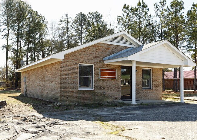
Harris Ave
694340901072
FLOYD-WRIGHT STATE FARM INSURANCE
Officebuilding
Hoke
X
North Carolina
3710943400J
0.28 AC
2025
Raeford
2025
Fayetteville
970107
Fayetteville, NC
1,040 SF
DEMOGRAPHICS near Harris Ave
1 mile
3 mile
5 mile
2024 Total Population
3,315
9,534
19,971
2029 Population
3,603
10,403
21,733
Pop Growth 2024-2029
+ 8.69%
+ 9.11%
+ 8.82%
Average Age
41
39
37
2024 Total Households
1,308
3,612
7,218
HH Growth 2024-2029
+ 8.64%
+ 9.00%
+ 8.69%
Median Household Inc
$31,000
$36,185
$39,840
Avg Household Size
2.40
2.50
2.70
2024 Avg HH Vehicles
2.00
2.00
2.00
Median Home Value
$142,985
$140,380
$142,732
Median Year Built
1973
1983
1993
Nearby Places
Map Layers
Map Styles
 Street
 Aerial
Transit
 Traffic
 Biking
Places
Listings with unknown addresses are not visible on the map
- Restaurants
- Banks
- Shops
- Fitness
- Groceries
PUBLIC TRANSPORTATION
AIRPORT
Fayetteville Regional/Grannis Field
Drive
Walk
Distance
Fayetteville Regional/Grannis Field
38 min
24.8 mi
Nearby Properties
Address
Land Use
TOTAL SIZE
Lot Size
Zoning
Address
Land Use
TOTAL SIZE
Lot Size
Zoning
236 SF
60.37 AC
Address
Land Use
TOTAL SIZE
Lot Size
Zoning
1,867 SF
54.94 AC
Address
Land Use
TOTAL SIZE
Lot Size
Zoning
1,022 SF
52.78 AC
Address
Land Use
TOTAL SIZE
Lot Size
Zoning
94,234 SF
22.81 AC
Address
Land Use
TOTAL SIZE
Lot Size
Zoning
428 SF
10 AC
Address
Land Use
TOTAL SIZE
Lot Size
Zoning
282 SF
1.86 AC
Address
Land Use
TOTAL SIZE
Lot Size
Zoning
742 SF
20.04 AC
Address
Land Use
TOTAL SIZE
Lot Size
Zoning
784 SF
14.18 AC
Address
Land Use
TOTAL SIZE
Lot Size
Zoning
2,186 SF
80.61 AC
Address
Land Use
TOTAL SIZE
Lot Size
Zoning
660 SF
17.79 AC
Address
Land Use
TOTAL SIZE
Lot Size
Zoning
276 SF
0.98 AC
Address
Land Use
TOTAL SIZE
Lot Size
Zoning
76,774 SF
8.76 AC
Address
Land Use
TOTAL SIZE
Lot Size
Zoning
2,450 SF
4.40 AC
Address
Land Use
TOTAL SIZE
Lot Size
Zoning
328 SF
10.20 AC
Address
Land Use
TOTAL SIZE
Lot Size
Zoning
42,947 SF
3.86 AC
Address
Land Use
TOTAL SIZE
Lot Size
Zoning
318 SF
5.10 AC
Address
Land Use
TOTAL SIZE
Lot Size
Zoning
186 SF
1.28 AC
Address
Land Use
TOTAL SIZE
Lot Size
Zoning
846 SF
1.38 AC
Address
Land Use
TOTAL SIZE
Lot Size
Zoning
300 SF
61.37 AC
Address
Land Use
TOTAL SIZE
Lot Size
Zoning
1,790 SF
0.06 AC
Address
Land Use
TOTAL SIZE
Lot Size
Zoning
300 SF
2.91 AC
Address
Land Use
TOTAL SIZE
Lot Size
Zoning
466 SF
1.56 AC
Address
Land Use
TOTAL SIZE
Lot Size
Zoning
640 SF
18.55 AC
Address
Land Use
TOTAL SIZE
Lot Size
Zoning
1,392 SF
14.86 AC
Address
Land Use
TOTAL SIZE
Lot Size
Zoning
664 SF
2.75 AC
Address
Land Use
TOTAL SIZE
Lot Size
Zoning
20,236 SF
4.99 AC
Address
Land Use
TOTAL SIZE
Lot Size
Zoning
8,660 SF
8.22 AC
Address
Land Use
TOTAL SIZE
Lot Size
Zoning
1,197 SF
5.32 AC
Address
Land Use
TOTAL SIZE
Lot Size
Zoning
1,192 AC
Address
Land Use
TOTAL SIZE
Lot Size
Zoning
15,328 SF
0.14 AC
The World's #1 Commercial Real Estate Marketplace
Connect with us
© 2026 CoStar Group
The information above has been obtained from sources believed reliable. While we do not doubt its accuracy we have not verified it and make no guarantee, warranty or representation about it. It is your responsibility to independently confirm its accuracy and completeness. Any projections, opinions, assumptions, or estimates used are for example only and do not represent the current or future performance of the property. The value of this transaction to you depends on tax and other factors which should be evaluated by your tax, financial, and legal advisors. You and your advisors should conduct a careful, independent investigation of the property to determine to your satisfaction the suitability of the property for your needs.