Property Record
Harrison Ave, Centralia, WA 98531
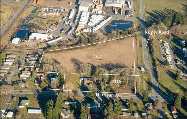

Property Detail
Harrison Ave
Centralia, WA
SECTION 25 TOWNSHIP 15N RANGE 03W PT LUARK DLC LY BTWN HARRISON AVE & RR R/W
023736-001-002
LEWIS
Residentialacreage
Washington
M1
8.12 AC
2024
Washington State Area
2024
Other Market Areas
970500
NEARBY LISTINGS FOR SALE OR LEASE
DEMOGRAPHICS near Harrison Ave
1 mile
3 mile
5 mile
2025 Total Population
880
13,876
33,041
2030 Population
899
14,305
34,052
Pop Growth 2025-2030
+ 2.16%
+ 3.09%
+ 3.06%
Average Age
42
40
40
2025 Total Households
360
5,298
12,407
HH Growth 2025-2030
+ 1.94%
+ 3.04%
+ 3.05%
Median Household Inc
$37,916
$61,331
$66,122
Avg Household Size
2.40
2.50
2.60
2025 Avg HH Vehicles
2.00
2.00
2.00
Median Home Value
$329,838
$340,957
$365,955
Median Year Built
1982
1982
1981
Nearby Places
Map Layers
Map Styles
 Street
 Aerial
Layers
 Traffic
 Biking
Places
Listings with unknown addresses are not visible on the map
- Restaurants
- Banks
- Shops
- Fitness
- Groceries
PUBLIC TRANSPORTATION
COMMUTER RAIL
Centralia Amtrak Station (Amtrak Cascades - Amtrak, Coast Starlight - Amtrak)
Drive
Walk
Distance
Centralia Amtrak Station (Amtrak Cascades - Amtrak, Coast Starlight - Amtrak)
9 min
4.0 mi
Freight Ports
Port of Grays Harbor, WA
Drive
Walk
Distance
Port of Grays Harbor, WA
78 min
51.2 mi
SALE & LEASE HISTORY
LISTING DATE
SALE/LEASE

Sep 24, 2016
For Sale
Apr 25, 2019
For Sale
Apr 22, 2022
For Lease
Nearby Properties
Address
Land Use
TOTAL SIZE
Lot Size
Zoning
Address
Land Use
TOTAL SIZE
Lot Size
Zoning
1,038,447 SF
77 AC
PMP
Address
Land Use
TOTAL SIZE
Lot Size
Zoning
441,608 SF
Address
Land Use
TOTAL SIZE
Lot Size
Zoning
41,582 SF
3.38 AC
PMP
Address
Land Use
TOTAL SIZE
Lot Size
Zoning
155,458 SF
15.79 AC
PMP
Address
Land Use
TOTAL SIZE
Lot Size
Zoning
231,419 SF
209.52 AC
PID
Address
Land Use
TOTAL SIZE
Lot Size
Zoning
738,962 SF
16.50 AC
Address
Land Use
TOTAL SIZE
Lot Size
Zoning
1,427 SF
15.22 AC
Address
Land Use
TOTAL SIZE
Lot Size
Zoning
129,242 SF
11.91 AC
M1
Address
Land Use
TOTAL SIZE
Lot Size
Zoning
17,920 SF
38.78 AC
OSPF
Address
Land Use
TOTAL SIZE
Lot Size
Zoning
142,368 SF
6.60 AC
R20
Address
Land Use
TOTAL SIZE
Lot Size
Zoning
196,060 SF
24.68 AC
PMP
Address
Land Use
TOTAL SIZE
Lot Size
Zoning
7,200 SF
3.81 AC
OSPF
Address
Land Use
TOTAL SIZE
Lot Size
Zoning
28,522 SF
2 AC
M2
Address
Land Use
TOTAL SIZE
Lot Size
Zoning
29,204 SF
3.91 AC
R20
Address
Land Use
TOTAL SIZE
Lot Size
Zoning
75,993 SF
18.76 AC
PMP
Address
Land Use
TOTAL SIZE
Lot Size
Zoning
Address
Land Use
TOTAL SIZE
Lot Size
Zoning
104,872 SF
Address
Land Use
TOTAL SIZE
Lot Size
Zoning
36,448 SF
1.73 AC
R20
Address
Land Use
TOTAL SIZE
Lot Size
Zoning
9,072 SF
8.57 AC
OSPF
Address
Land Use
TOTAL SIZE
Lot Size
Zoning
21,672 SF
2.08 AC
R20
Address
Land Use
TOTAL SIZE
Lot Size
Zoning
77,511 SF
3.58 AC
C1
Address
Land Use
TOTAL SIZE
Lot Size
Zoning
940 SF
1.50 AC
Address
Land Use
TOTAL SIZE
Lot Size
Zoning
1,161 SF
2.11 AC
R15
Address
Land Use
TOTAL SIZE
Lot Size
Zoning
12,850 SF
1.48 AC
R15
Address
Land Use
TOTAL SIZE
Lot Size
Zoning
4,104 SF
79.55 AC
M2
Address
Land Use
TOTAL SIZE
Lot Size
Zoning
15,947 SF
2.14 AC
C2
Address
Land Use
TOTAL SIZE
Lot Size
Zoning
34,579 SF
94.12 AC
OSPF
Address
Land Use
TOTAL SIZE
Lot Size
Zoning
35,000 SF
2.13 AC
C2
Address
Land Use
TOTAL SIZE
Lot Size
Zoning
7.13 AC
Address
Land Use
TOTAL SIZE
Lot Size
Zoning
55,928 SF
5.10 AC
C2
The World's #1 Commercial Real Estate Marketplace
Connect with us
© 2026 CoStar Group
The information above has been obtained from sources believed reliable. While we do not doubt its accuracy we have not verified it and make no guarantee, warranty or representation about it. It is your responsibility to independently confirm its accuracy and completeness. Any projections, opinions, assumptions, or estimates used are for example only and do not represent the current or future performance of the property. The value of this transaction to you depends on tax and other factors which should be evaluated by your tax, financial, and legal advisors. You and your advisors should conduct a careful, independent investigation of the property to determine to your satisfaction the suitability of the property for your needs.