Property Record
Harrison Mill Rd, Winder, GA 30680
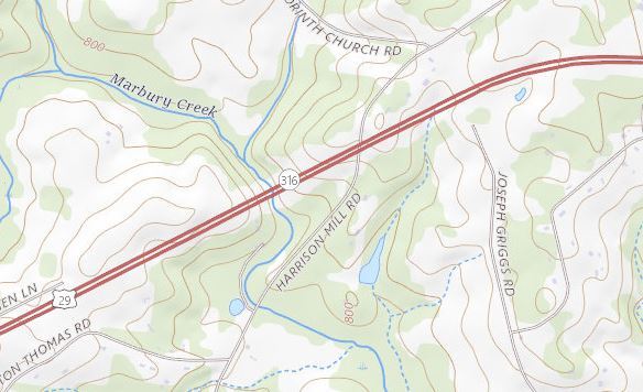

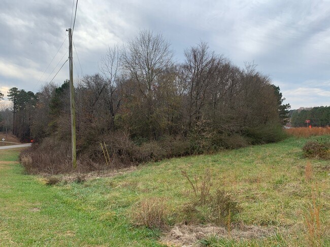
This Property Is For Sale
Property Detail
Harrison Mill Rd
BE04-003A
TRACT 2 7.367 AC
Agriculturalland
BARROW
AG
Georgia
A Areas with a 1% annual chance of flooding and a 26% chance of flooding over the life of a 30-year mortgage.
7.37 AC
2025
Barrow County
2025
Atlanta
180203
Atlanta-Sandy Springs-Roswell, GA
NEARBY LISTINGS FOR SALE OR LEASE
DEMOGRAPHICS near Harrison Mill Rd
1 mile
3 mile
5 mile
2025 Total Population
494
14,359
49,832
2030 Population
559
16,291
56,449
Pop Growth 2025-2030
+ 13.16%
+ 13.45%
+ 13.28%
Average Age
38
37
37
2025 Total Households
168
4,806
17,223
HH Growth 2025-2030
+ 13.69%
+ 13.55%
+ 13.32%
Median Household Inc
$55,517
$59,496
$64,025
Avg Household Size
2.90
2.90
2.80
2025 Avg HH Vehicles
3.00
2.00
2.00
Median Home Value
$354,255
$279,238
$291,679
Median Year Built
1997
1999
2001
Nearby Places
Map Layers
Map Styles
 Street
 Aerial
Layers
 Traffic
 Biking
Places
Listings with unknown addresses are not visible on the map
- Restaurants
- Banks
- Shops
- Fitness
- Groceries
Nearby Properties
Address
Land Use
TOTAL SIZE
Lot Size
Zoning
Address
Land Use
TOTAL SIZE
Lot Size
Zoning
1,456 SF
1,732.81 AC
G
Address
Land Use
TOTAL SIZE
Lot Size
Zoning
275,840 SF
22.10 AC
M-1
Address
Land Use
TOTAL SIZE
Lot Size
Zoning
6,424 SF
11.63 AC
B-2,R-3
Address
Land Use
TOTAL SIZE
Lot Size
Zoning
26,789 SF
35.64 AC
C-3
Address
Land Use
TOTAL SIZE
Lot Size
Zoning
66,052 SF
30.25 AC
AG
Address
Land Use
TOTAL SIZE
Lot Size
Zoning
85,000 SF
85.91 AC
AC
Address
Land Use
TOTAL SIZE
Lot Size
Zoning
6,928 SF
358.89 AC
AC
Address
Land Use
TOTAL SIZE
Lot Size
Zoning
2,046 SF
12.97 AC
B-2,R-3
Address
Land Use
TOTAL SIZE
Lot Size
Zoning
20,132 SF
56.30 AC
M-2
Address
Land Use
TOTAL SIZE
Lot Size
Zoning
132,156 SF
10.05 AC
C-2
Address
Land Use
TOTAL SIZE
Lot Size
Zoning
79,029 SF
9.72 AC
C-2
Address
Land Use
TOTAL SIZE
Lot Size
Zoning
65,340 SF
11.81 AC
C-3
Address
Land Use
TOTAL SIZE
Lot Size
Zoning
81,934 SF
30.94 AC
M-2
Address
Land Use
TOTAL SIZE
Lot Size
Zoning
3,370 SF
352.38 AC
G,TNPD
Address
Land Use
TOTAL SIZE
Lot Size
Zoning
37,162 SF
4.62 AC
R-3
Address
Land Use
TOTAL SIZE
Lot Size
Zoning
3,462 SF
10.05 AC
G,R-3
Address
Land Use
TOTAL SIZE
Lot Size
Zoning
26,802 SF
5 AC
AG
Address
Land Use
TOTAL SIZE
Lot Size
Zoning
20,857 SF
39.58 AC
M-1
Address
Land Use
TOTAL SIZE
Lot Size
Zoning
24,982 SF
16.08 AC
R-1
Address
Land Use
TOTAL SIZE
Lot Size
Zoning
8,916 SF
67.07 AC
R-3
Address
Land Use
TOTAL SIZE
Lot Size
Zoning
46,339 SF
2 AC
B-2
Address
Land Use
TOTAL SIZE
Lot Size
Zoning
85,290 SF
29.13 AC
C-3
Address
Land Use
TOTAL SIZE
Lot Size
Zoning
20,592 SF
66.11 AC
G
Address
Land Use
TOTAL SIZE
Lot Size
Zoning
76,768 SF
19.04 AC
AG
Address
Land Use
TOTAL SIZE
Lot Size
Zoning
67,000 SF
20 AC
AC
Address
Land Use
TOTAL SIZE
Lot Size
Zoning
45,296 SF
8.18 AC
B-2
Address
Land Use
TOTAL SIZE
Lot Size
Zoning
143,025 SF
9.30 AC
M-1
Address
Land Use
TOTAL SIZE
Lot Size
Zoning
19,483 SF
2.76 AC
B-2
Address
Land Use
TOTAL SIZE
Lot Size
Zoning
34,355 SF
24.48 AC
AG
Address
Land Use
TOTAL SIZE
Lot Size
Zoning
11,914 SF
6.91 AC
G,R-2,R-3
The World's #1 Commercial Real Estate Marketplace
Connect with us
© 2026 CoStar Group
The information above has been obtained from sources believed reliable. While we do not doubt its accuracy we have not verified it and make no guarantee, warranty or representation about it. It is your responsibility to independently confirm its accuracy and completeness. Any projections, opinions, assumptions, or estimates used are for example only and do not represent the current or future performance of the property. The value of this transaction to you depends on tax and other factors which should be evaluated by your tax, financial, and legal advisors. You and your advisors should conduct a careful, independent investigation of the property to determine to your satisfaction the suitability of the property for your needs.