Property Record
Harvard Dr, Chesapeake, VA 23324

Save to a Folder
{{folder.Name}}
{{folder.ListingIds.length}} Properties
{{folder.ListingIds.length}} Property
Create a New Folder
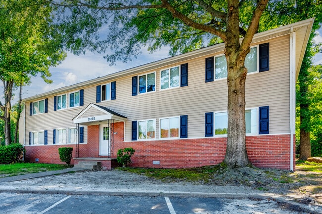
Property Detail
Harvard Dr
1450000001570
10.10 AC ON GT BRIDGE BLVD
Apartmenthouse5plusunits
CHESAPEAKE
RMF1: MULT
Virginia
AE The base floodplain where base flood elevations are provided. AE Zones are now used on new format FIRMs instead of A1-A30 Zones.
10.10 AC
2025
South Norfolk
2025
Hampton Roads
020600
Virginia Beach-Chesapeake-Norfolk, VA-NC
108,864 SF
NEARBY LISTINGS FOR SALE OR LEASE
DEMOGRAPHICS near Harvard Dr
1 mile
3 mile
5 mile
2025 Total Population
7,146
80,045
241,803
2030 Population
7,278
80,852
242,517
Pop Growth 2025-2030
+ 1.85%
+ 1.01%
+ 0.30%
Average Age
38
37
38
2025 Total Households
2,654
31,274
97,467
HH Growth 2025-2030
+ 1.92%
+ 1.02%
+ 0.22%
Median Household Inc
$74,973
$57,479
$64,779
Avg Household Size
2.60
2.50
2.40
2025 Avg HH Vehicles
2.00
2.00
2.00
Median Home Value
$267,988
$256,711
$287,226
Median Year Built
1963
1974
1978
Nearby Places
Map Layers
Map Styles
 Street
 Aerial
Layers
 Traffic
 Biking
Places
Listings with unknown addresses are not visible on the map
- Restaurants
- Banks
- Shops
- Fitness
- Groceries
PUBLIC TRANSPORTATION
COMMUTER RAIL
Norfolk (Northeast Regional - Amtrak)
Drive
Walk
Distance
Norfolk (Northeast Regional - Amtrak)
8 min
4.4 mi
AIRPORT
Norfolk International
Drive
Walk
Distance
Norfolk International
19 min
9.7 mi
Newport News/Williamsburg International
Drive
Walk
Distance
Newport News/Williamsburg International
48 min
32.5 mi
Freight Ports
Virginia Port Authority - Portsmouth
Drive
Walk
Distance
Virginia Port Authority - Portsmouth
17 min
8.3 mi
SALE & LEASE HISTORY
LISTING DATE
SALE/LEASE

May 27, 2025
For Sale
Aug 01, 2022
For Sale
Nearby Properties
Address
Land Use
TOTAL SIZE
Lot Size
Zoning
Address
Land Use
TOTAL SIZE
Lot Size
Zoning
405,992 SF
40.22 AC
PUD: PLANN
Address
Land Use
TOTAL SIZE
Lot Size
Zoning
482.38 AC
MULTI: MUL
Address
Land Use
TOTAL SIZE
Lot Size
Zoning
743,121 SF
57.42 AC
RMF1: MULT
Address
Land Use
TOTAL SIZE
Lot Size
Zoning
689,954 SF
63.25 AC
Address
Land Use
TOTAL SIZE
Lot Size
Zoning
473,072 SF
9.72 AC
SD
Address
Land Use
TOTAL SIZE
Lot Size
Zoning
358,908 SF
22.21 AC
MULTI: MUL
Address
Land Use
TOTAL SIZE
Lot Size
Zoning
258,000 SF
1.38 AC
M2: GENERA
Address
Land Use
TOTAL SIZE
Lot Size
Zoning
209,403 SF
2.81 AC
PUD: PLANN
Address
Land Use
TOTAL SIZE
Lot Size
Zoning
264,213 SF
17.59 AC
PUD: PLANN
Address
Land Use
TOTAL SIZE
Lot Size
Zoning
252,524 SF
20 AC
R8S: RESID
Address
Land Use
TOTAL SIZE
Lot Size
Zoning
188,152 SF
16.93 AC
Address
Land Use
TOTAL SIZE
Lot Size
Zoning
32,163 SF
17.59 AC
MULTI: MUL
Address
Land Use
TOTAL SIZE
Lot Size
Zoning
92,723 SF
28.83 AC
R6: RESIDE
Address
Land Use
TOTAL SIZE
Lot Size
Zoning
366,720 SF
23 AC
RMF1: MULT
Address
Land Use
TOTAL SIZE
Lot Size
Zoning
401,302 SF
18.74 AC
M2: GENERA
Address
Land Use
TOTAL SIZE
Lot Size
Zoning
128,596 SF
16.91 AC
M2: GENERA
Address
Land Use
TOTAL SIZE
Lot Size
Zoning
142,656 SF
22.17 AC
RMF1: MULT
Address
Land Use
TOTAL SIZE
Lot Size
Zoning
287,268 SF
83.63 AC
MULTI: MUL
Address
Land Use
TOTAL SIZE
Lot Size
Zoning
127,755 SF
14.68 AC
PUD: PLANN
Address
Land Use
TOTAL SIZE
Lot Size
Zoning
162,291 SF
2.98 AC
PUD: PLANN
Address
Land Use
TOTAL SIZE
Lot Size
Zoning
237,629 SF
2.65 AC
T6
Address
Land Use
TOTAL SIZE
Lot Size
Zoning
1,880 SF
13.30 AC
PUD: PLANN
Address
Land Use
TOTAL SIZE
Lot Size
Zoning
166,753 SF
1.46 AC
PUD: PLANN
Address
Land Use
TOTAL SIZE
Lot Size
Zoning
750 SF
103.88 AC
I5
Address
Land Use
TOTAL SIZE
Lot Size
Zoning
12,240 SF
20.98 AC
MULTI: MUL
Address
Land Use
TOTAL SIZE
Lot Size
Zoning
1,766 SF
17 AC
Address
Land Use
TOTAL SIZE
Lot Size
Zoning
345,432 SF
17.14 AC
PUD: PLANN
Address
Land Use
TOTAL SIZE
Lot Size
Zoning
28,253 SF
32.34 AC
M3: WATERF
Address
Land Use
TOTAL SIZE
Lot Size
Zoning
119,946 SF
9.76 AC
M2: GENERA
Address
Land Use
TOTAL SIZE
Lot Size
Zoning
336,005 SF
15.32 AC
M1: LIGHT
The World's #1 Commercial Real Estate Marketplace
Connect with us
© 2026 CoStar Group
The information above has been obtained from sources believed reliable. While we do not doubt its accuracy we have not verified it and make no guarantee, warranty or representation about it. It is your responsibility to independently confirm its accuracy and completeness. Any projections, opinions, assumptions, or estimates used are for example only and do not represent the current or future performance of the property. The value of this transaction to you depends on tax and other factors which should be evaluated by your tax, financial, and legal advisors. You and your advisors should conduct a careful, independent investigation of the property to determine to your satisfaction the suitability of the property for your needs.