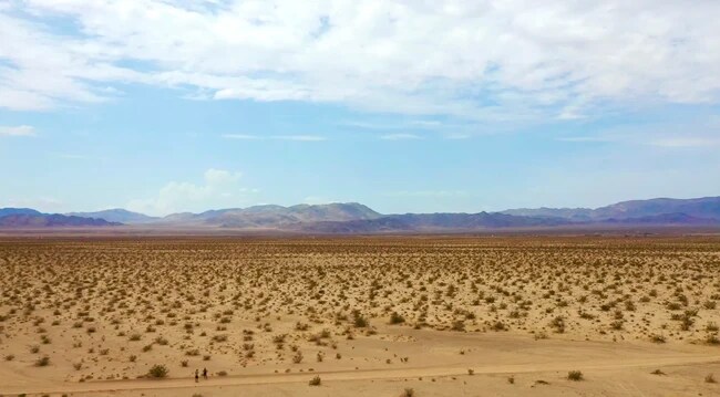
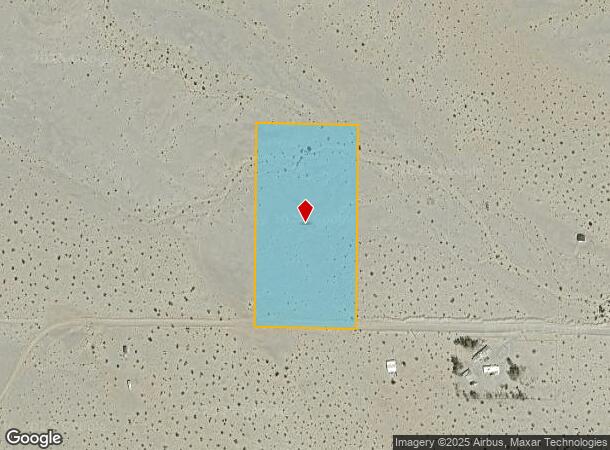
Property Record
Harvest Trl, Twentynine Palms, CA 92277
NEARBY LISTINGS FOR SALE OR LEASE
-
-
View all Twentynine Palms listings for sale on LoopNet.com
Property Detail
Harvest Trl
0628-161-19
W 1/2 SW 1/4 NE 1/4 SE 1/4 SEC 21 TP 1N R 11E 5. AC
Vacantlandnec
San Bernardino
X
California
06071C8250H
5 AC
2024
Twentynine Palms
2025
Inland Empire (California)
010422
Riverside-San Bernardino-Ontario, CA
DEMOGRAPHICS near Harvest Trl
1 Mile
3 Mile
5 Mile
2024 Total Population
15
294
681
2029 Population
16
311
720
Pop Growth 2024-2029
+ 6.67%
+ 5.78%
+ 5.73%
Average Age
56
51
51
2024 Total Households
9
162
375
HH Growth 2024-2029
0.00%
+ 5.56%
+ 5.60%
Median Household Inc
$55,000
$50,139
$47,999
Avg Household Size
1.90
1.80
1.80
2024 Avg HH Vehicles
2.00
2.00
2.00
Median Home Value
$625,000
$172,727
$137,037
Median Year Built
1955
1956
1956
Nearby Places
Map Layers
Map Styles
 Street
 Aerial
- Restaurants
- Banks
- Shops
- Fitness
- Groceries
SALE & LEASE HISTORY
LISTING DATE
SALE/LEASE

Sep 23, 2021
For Sale
Nearby Properties
Address
Land Use
TOTAL SIZE
Lot Size
Zoning
Address
Land Use
TOTAL SIZE
Lot Size
Zoning
24,000 SF
5 AC
CS
Address
Land Use
TOTAL SIZE
Lot Size
Zoning
400 SF
5 AC
RL5
Address
Land Use
TOTAL SIZE
Lot Size
Zoning
5 AC
RL5
Address
Land Use
TOTAL SIZE
Lot Size
Zoning
384 SF
5 AC
RL5
Address
Land Use
TOTAL SIZE
Lot Size
Zoning
408 SF
5 AC
RL5
Address
Land Use
TOTAL SIZE
Lot Size
Zoning
408 SF
5.14 AC
RL5
Address
Land Use
TOTAL SIZE
Lot Size
Zoning
2.50 AC
RL5
Address
Land Use
TOTAL SIZE
Lot Size
Zoning
5 AC
RL5
Address
Land Use
TOTAL SIZE
Lot Size
Zoning
5 AC
RL5
Address
Land Use
TOTAL SIZE
Lot Size
Zoning
5 AC
RL5
Address
Land Use
TOTAL SIZE
Lot Size
Zoning
5 AC
RL5
Address
Land Use
TOTAL SIZE
Lot Size
Zoning
5 AC
RL5
Address
Land Use
TOTAL SIZE
Lot Size
Zoning
Address
Land Use
TOTAL SIZE
Lot Size
Zoning
5.29 AC
RL5
Address
Land Use
TOTAL SIZE
Lot Size
Zoning
400 SF
5 AC
RL5
Address
Land Use
TOTAL SIZE
Lot Size
Zoning
Address
Land Use
TOTAL SIZE
Lot Size
Zoning
5 AC
RL5
Address
Land Use
TOTAL SIZE
Lot Size
Zoning
416 SF
5 AC
RL5
Address
Land Use
TOTAL SIZE
Lot Size
Zoning
5 AC
RL5
Address
Land Use
TOTAL SIZE
Lot Size
Zoning
5.47 AC
RL5
Address
Land Use
TOTAL SIZE
Lot Size
Zoning
5 AC
RL5
Address
Land Use
TOTAL SIZE
Lot Size
Zoning
5 AC
RL5
Address
Land Use
TOTAL SIZE
Lot Size
Zoning
5 AC
RL5
Address
Land Use
TOTAL SIZE
Lot Size
Zoning
768 SF
5 AC
RL5
Address
Land Use
TOTAL SIZE
Lot Size
Zoning
5 AC
RL5
Address
Land Use
TOTAL SIZE
Lot Size
Zoning
408 SF
5 AC
RL5
Address
Land Use
TOTAL SIZE
Lot Size
Zoning
5 AC
RL5
Address
Land Use
TOTAL SIZE
Lot Size
Zoning
18 AC
RL5
Address
Land Use
TOTAL SIZE
Lot Size
Zoning
192 SF
5 AC
RL5
Address
Land Use
TOTAL SIZE
Lot Size
Zoning
5.08 AC
RL5
The World's #1 Commercial Real Estate Marketplace
Connect with us
© 2025 CoStar Group
The information above has been obtained from sources believed reliable. While we do not doubt its accuracy we have not verified it and make no guarantee, warranty or representation about it. It is your responsibility to independently confirm its accuracy and completeness. Any projections, opinions, assumptions, or estimates used are for example only and do not represent the current or future performance of the property. The value of this transaction to you depends on tax and other factors which should be evaluated by your tax, financial, and legal advisors. You and your advisors should conduct a careful, independent investigation of the property to determine to your satisfaction the suitability of the property for your needs.