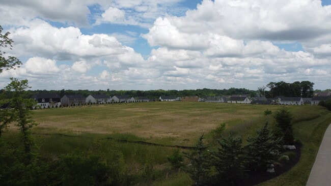
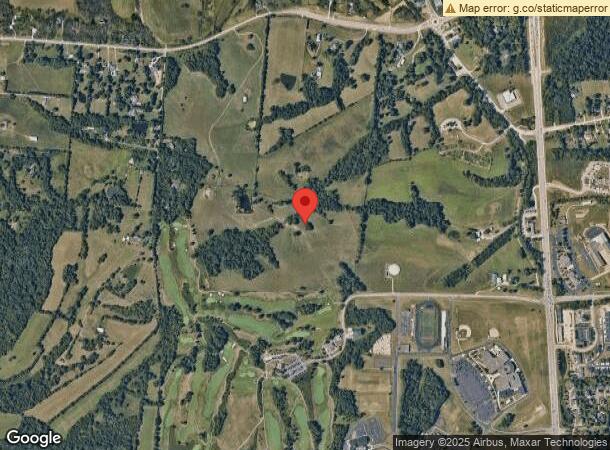
Property Record
Hathaway Rd, Union, KY 41091
Property Detail
Hathaway Rd
Cincinnati, OH-KY-IN
5.4482 AC LONG BRANCH RD
051.00-00-007.10
BOONE
Residentialacreage
Kentucky
2024
5.45 AC
2024
Outlying N Kentucky
070601
Cincinnati/Dayton
NEARBY LISTINGS FOR SALE OR LEASE
DEMOGRAPHICS near Hathaway Rd
1 mile
3 mile
5 mile
2025 Total Population
3,301
40,700
95,758
2030 Population
3,592
43,062
101,041
Pop Growth 2025-2030
+ 8.82%
+ 5.80%
+ 5.52%
Average Age
38
39
39
2025 Total Households
1,080
14,399
35,349
HH Growth 2025-2030
+ 8.98%
+ 5.92%
+ 5.62%
Median Household Inc
$139,439
$107,642
$88,527
Avg Household Size
3.00
2.80
2.60
2025 Avg HH Vehicles
2.00
2.00
2.00
Median Home Value
$374,637
$317,085
$286,490
Median Year Built
2009
2000
1996
Nearby Places
Map Layers
Map Styles
 Street
 Aerial
Transit
 Traffic
 Biking
Places
Listings with unknown addresses are not visible on the map
- Restaurants
- Banks
- Shops
- Fitness
- Groceries
SALE & LEASE HISTORY
LISTING DATE
SALE/LEASE

Oct 25, 2024
For Sale
May 30, 2023
For Sale
Nearby Properties
Address
Land Use
TOTAL SIZE
Lot Size
Zoning
Address
Land Use
TOTAL SIZE
Lot Size
Zoning
153.53 AC
Address
Land Use
TOTAL SIZE
Lot Size
Zoning
1,824 SF
7.68 AC
Address
Land Use
TOTAL SIZE
Lot Size
Zoning
19,542 SF
16.64 AC
Address
Land Use
TOTAL SIZE
Lot Size
Zoning
21.50 AC
Address
Land Use
TOTAL SIZE
Lot Size
Zoning
Address
Land Use
TOTAL SIZE
Lot Size
Zoning
14.10 AC
Address
Land Use
TOTAL SIZE
Lot Size
Zoning
25.60 AC
Address
Land Use
TOTAL SIZE
Lot Size
Zoning
4,900 SF
4.06 AC
Address
Land Use
TOTAL SIZE
Lot Size
Zoning
39.62 AC
Address
Land Use
TOTAL SIZE
Lot Size
Zoning
2,318 SF
113.25 AC
Address
Land Use
TOTAL SIZE
Lot Size
Zoning
7.98 AC
Address
Land Use
TOTAL SIZE
Lot Size
Zoning
14.32 AC
Address
Land Use
TOTAL SIZE
Lot Size
Zoning
10.83 AC
Address
Land Use
TOTAL SIZE
Lot Size
Zoning
32.07 AC
Address
Land Use
TOTAL SIZE
Lot Size
Zoning
12.95 AC
Address
Land Use
TOTAL SIZE
Lot Size
Zoning
11.98 AC
Address
Land Use
TOTAL SIZE
Lot Size
Zoning
23.25 AC
Address
Land Use
TOTAL SIZE
Lot Size
Zoning
9.98 AC
Address
Land Use
TOTAL SIZE
Lot Size
Zoning
3.48 AC
Address
Land Use
TOTAL SIZE
Lot Size
Zoning
14,826 SF
1.66 AC
Address
Land Use
TOTAL SIZE
Lot Size
Zoning
9.52 AC
Address
Land Use
TOTAL SIZE
Lot Size
Zoning
2,080 SF
146 AC
Address
Land Use
TOTAL SIZE
Lot Size
Zoning
1,740 SF
302 AC
Address
Land Use
TOTAL SIZE
Lot Size
Zoning
140.39 AC
Address
Land Use
TOTAL SIZE
Lot Size
Zoning
4,830 SF
145.10 AC
Address
Land Use
TOTAL SIZE
Lot Size
Zoning
5,323 SF
6.20 AC
Address
Land Use
TOTAL SIZE
Lot Size
Zoning
896 SF
66.34 AC
Address
Land Use
TOTAL SIZE
Lot Size
Zoning
2,320 SF
396 AC
Address
Land Use
TOTAL SIZE
Lot Size
Zoning
3.35 AC
Address
Land Use
TOTAL SIZE
Lot Size
Zoning
10.04 AC
The World's #1 Commercial Real Estate Marketplace
Connect with us
© 2026 CoStar Group
The information above has been obtained from sources believed reliable. While we do not doubt its accuracy we have not verified it and make no guarantee, warranty or representation about it. It is your responsibility to independently confirm its accuracy and completeness. Any projections, opinions, assumptions, or estimates used are for example only and do not represent the current or future performance of the property. The value of this transaction to you depends on tax and other factors which should be evaluated by your tax, financial, and legal advisors. You and your advisors should conduct a careful, independent investigation of the property to determine to your satisfaction the suitability of the property for your needs.