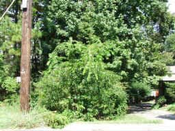
Property Record
Hawthorne Ave, Smyrna, GA 30080
NEARBY LISTINGS FOR SALE OR LEASE
-
-
-
-
-
-
-
No Photo
-
View all Smyrna listings for sale on LoopNet.com
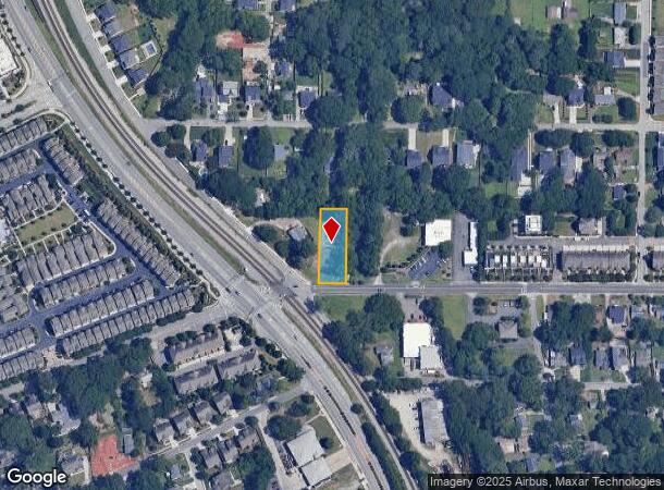
Property Detail
Hawthorne Ave
Atlanta-Sandy Springs-Roswell, GA
Taylor
17-0519-0-090-0
TAYLOR
Commercialacreage
Cobb
X
Georgia
13067C0119H
519
2025
0.39 AC
2025
Cumberland/Galleria
031111
Atlanta
DEMOGRAPHICS near Hawthorne Ave
1 Mile
3 Mile
5 Mile
2024 Total Population
11,284
108,271
247,913
2029 Population
11,566
110,886
253,144
Pop Growth 2024-2029
+ 2.50%
+ 2.42%
+ 2.11%
Average Age
36
36
37
2024 Total Households
4,966
46,659
107,085
HH Growth 2024-2029
+ 2.52%
+ 2.36%
+ 2.07%
Median Household Inc
$79,855
$68,973
$77,531
Avg Household Size
2.20
2.30
2.20
2024 Avg HH Vehicles
2.00
2.00
2.00
Median Home Value
$379,589
$345,868
$353,437
Median Year Built
1983
1985
1986
Nearby Places
Map Layers
Map Styles
 Street
 Aerial
- Restaurants
- Banks
- Shops
- Fitness
- Groceries
PUBLIC TRANSPORTATION
AIRPORT
Hartsfield - Jackson Atlanta International
DRIVE
WALK
Distance
Hartsfield - Jackson Atlanta International
36 min
24.7 mi
Freight Ports
Georgia Ports - Savannah
DRIVE
WALK
Distance
Georgia Ports - Savannah
299 min
264.3 mi
Nearby Properties
Address
Land Use
TOTAL SIZE
Lot Size
Zoning
Address
Land Use
TOTAL SIZE
Lot Size
Zoning
41,500 SF
15.61 AC
RRC
Address
Land Use
TOTAL SIZE
Lot Size
Zoning
3,929,999 SF
32.70 AC
OHR
Address
Land Use
TOTAL SIZE
Lot Size
Zoning
649,754 SF
20.73 AC
PSC/CRC
Address
Land Use
TOTAL SIZE
Lot Size
Zoning
417,453 SF
21.94 AC
RMR
Address
Land Use
TOTAL SIZE
Lot Size
Zoning
553,125 SF
42.07 AC
PRD MF
Address
Land Use
TOTAL SIZE
Lot Size
Zoning
5.36 AC
RRC
Address
Land Use
TOTAL SIZE
Lot Size
Zoning
237,743 SF
10.32 AC
RRC
Address
Land Use
TOTAL SIZE
Lot Size
Zoning
468,079 SF
31.79 AC
RMR
Address
Land Use
TOTAL SIZE
Lot Size
Zoning
583,570 SF
4.56 AC
PVC/OI
Address
Land Use
TOTAL SIZE
Lot Size
Zoning
483,147 SF
29.70 AC
RM-16
Address
Land Use
TOTAL SIZE
Lot Size
Zoning
3.51 AC
RRC
Address
Land Use
TOTAL SIZE
Lot Size
Zoning
612,660 SF
46.67 AC
RM-16
Address
Land Use
TOTAL SIZE
Lot Size
Zoning
389,428 SF
22.50 AC
RM12
Address
Land Use
TOTAL SIZE
Lot Size
Zoning
560,836 SF
60.28 AC
RM-8
Address
Land Use
TOTAL SIZE
Lot Size
Zoning
379,000 SF
29.86 AC
RM-12
Address
Land Use
TOTAL SIZE
Lot Size
Zoning
486,095 SF
5.57 AC
UC
Address
Land Use
TOTAL SIZE
Lot Size
Zoning
437,793 SF
41.12 AC
RM-16
Address
Land Use
TOTAL SIZE
Lot Size
Zoning
606,936 SF
7.92 AC
GC
Address
Land Use
TOTAL SIZE
Lot Size
Zoning
258,674 SF
1.81 AC
RRC
Address
Land Use
TOTAL SIZE
Lot Size
Zoning
2,174 SF
4.02 AC
RRC
Address
Land Use
TOTAL SIZE
Lot Size
Zoning
424,402 SF
34.46 AC
RM-12
Address
Land Use
TOTAL SIZE
Lot Size
Zoning
504,744 SF
44.36 AC
RM-12
Address
Land Use
TOTAL SIZE
Lot Size
Zoning
325,339 SF
8.52 AC
RRC
Address
Land Use
TOTAL SIZE
Lot Size
Zoning
2.96 AC
RRC
Address
Land Use
TOTAL SIZE
Lot Size
Zoning
343,488 SF
2.15 AC
RRC
Address
Land Use
TOTAL SIZE
Lot Size
Zoning
122,154 SF
3.40 AC
RRC
Address
Land Use
TOTAL SIZE
Lot Size
Zoning
85,489 SF
6.20 AC
PRD MF
Address
Land Use
TOTAL SIZE
Lot Size
Zoning
478,466 SF
25.90 AC
RM-12
Address
Land Use
TOTAL SIZE
Lot Size
Zoning
357,031 SF
10.69 AC
MU
Address
Land Use
TOTAL SIZE
Lot Size
Zoning
285,395 SF
26.58 AC
RM-12
The World's #1 Commercial Real Estate Marketplace
Connect with us
© 2025 CoStar Group
The information above has been obtained from sources believed reliable. While we do not doubt its accuracy we have not verified it and make no guarantee, warranty or representation about it. It is your responsibility to independently confirm its accuracy and completeness. Any projections, opinions, assumptions, or estimates used are for example only and do not represent the current or future performance of the property. The value of this transaction to you depends on tax and other factors which should be evaluated by your tax, financial, and legal advisors. You and your advisors should conduct a careful, independent investigation of the property to determine to your satisfaction the suitability of the property for your needs.