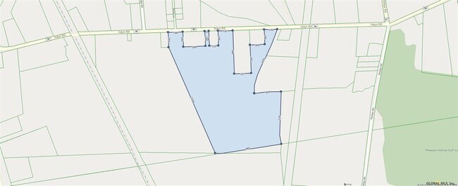
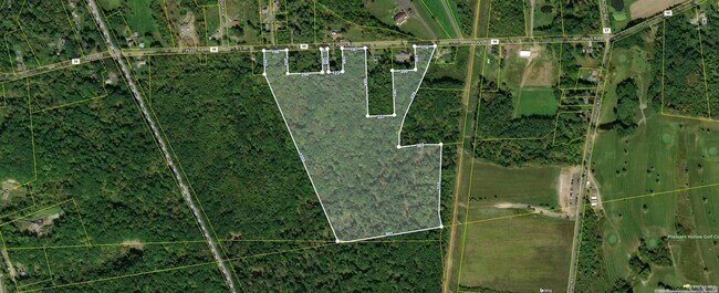
Property Record
Hays Rd, , NY

Property Detail
Hays Rd
Albany-Schenectady-Troy, NY
PART SCHODACK 177.-8-41
2400-177-5-27.11
RENSSELAER
Residentialacreage
New York
R-B
27.011
2025
37.34 AC
2024
Outer Rensselaer County
052408
Albany/Schenectady/Troy
NEARBY LISTINGS FOR SALE OR LEASE
DEMOGRAPHICS near Hays Rd
1 mile
3 mile
5 mile
2025 Total Population
920
16,268
57,107
2030 Population
930
16,302
57,363
Pop Growth 2025-2030
+ 1.09%
+ 0.21%
+ 0.45%
Average Age
43
44
41
2025 Total Households
353
7,028
24,231
HH Growth 2025-2030
+ 1.13%
+ 0.13%
+ 0.53%
Median Household Inc
$132,237
$96,610
$82,219
Avg Household Size
2.50
2.30
2.30
2025 Avg HH Vehicles
2.00
2.00
2.00
Median Home Value
$294,317
$267,705
$273,908
Median Year Built
1976
1973
1967
Nearby Places
Map Layers
Map Styles
 Street
 Aerial
Transit
 Traffic
 Biking
Places
Listings with unknown addresses are not visible on the map
- Restaurants
- Banks
- Shops
- Fitness
- Groceries
PUBLIC TRANSPORTATION
COMMUTER RAIL
Albany-Rensselaer Amtrak Station (Adirondack - Amtrak, Empire Service - Amtrak, Ethan Allen Express - Amtrak, Lake Shore Limited - Amtrak, Maple Leaf - Amtrak)
Drive
Walk
Distance
Albany-Rensselaer Amtrak Station (Adirondack - Amtrak, Empire Service - Amtrak, Ethan Allen Express - Amtrak, Lake Shore Limited - Amtrak, Maple Leaf - Amtrak)
10 min
4.9 mi
AIRPORT
Albany International
Drive
Walk
Distance
Albany International
31 min
16.9 mi
Freight Ports
Albany, NY Port
Drive
Walk
Distance
Albany, NY Port
16 min
7.3 mi
SALE & LEASE HISTORY
LISTING DATE
SALE/LEASE

Oct 13, 2020
For Sale
Nearby Properties
Address
Land Use
TOTAL SIZE
Lot Size
Zoning
Address
Land Use
TOTAL SIZE
Lot Size
Zoning
83.50 AC
Address
Land Use
TOTAL SIZE
Lot Size
Zoning
44,712 SF
25.58 AC
R-3
Address
Land Use
TOTAL SIZE
Lot Size
Zoning
99,223 SF
15.47 AC
R-B
Address
Land Use
TOTAL SIZE
Lot Size
Zoning
102,995 SF
153.50 AC
RR
Address
Land Use
TOTAL SIZE
Lot Size
Zoning
0.01 AC
I
Address
Land Use
TOTAL SIZE
Lot Size
Zoning
6,720 SF
15.68 AC
R-3
Address
Land Use
TOTAL SIZE
Lot Size
Zoning
62,712 SF
17.45 AC
B-2
Address
Land Use
TOTAL SIZE
Lot Size
Zoning
141,024 SF
13.53 AC
B-2
Address
Land Use
TOTAL SIZE
Lot Size
Zoning
6,388 SF
28.34 AC
A-R
Address
Land Use
TOTAL SIZE
Lot Size
Zoning
10,080 SF
11.31 AC
PDD
Address
Land Use
TOTAL SIZE
Lot Size
Zoning
126,241 SF
14.50 AC
B-2
Address
Land Use
TOTAL SIZE
Lot Size
Zoning
126,241 SF
11.50 AC
B-2
Address
Land Use
TOTAL SIZE
Lot Size
Zoning
12,088 SF
42.30 AC
I
Address
Land Use
TOTAL SIZE
Lot Size
Zoning
122,272 SF
16.71 AC
B-2
Address
Land Use
TOTAL SIZE
Lot Size
Zoning
177,492 SF
52.63 AC
R-B
Address
Land Use
TOTAL SIZE
Lot Size
Zoning
27,192 SF
8.52 AC
B-2
Address
Land Use
TOTAL SIZE
Lot Size
Zoning
5,532 SF
33.96 AC
R-40
Address
Land Use
TOTAL SIZE
Lot Size
Zoning
47,016 SF
13 AC
R-B
Address
Land Use
TOTAL SIZE
Lot Size
Zoning
4.76 AC
R-B
Address
Land Use
TOTAL SIZE
Lot Size
Zoning
10,800 SF
11.94 AC
PDD
Address
Land Use
TOTAL SIZE
Lot Size
Zoning
17,212 SF
88.10 AC
I
Address
Land Use
TOTAL SIZE
Lot Size
Zoning
2,187 SF
5.06 AC
R-3
Address
Land Use
TOTAL SIZE
Lot Size
Zoning
5,050 SF
7.07 AC
R-3
Address
Land Use
TOTAL SIZE
Lot Size
Zoning
102,000 SF
11.80 AC
PD-3
Address
Land Use
TOTAL SIZE
Lot Size
Zoning
133,680 SF
34.98 AC
R-B
Address
Land Use
TOTAL SIZE
Lot Size
Zoning
0.01 AC
Address
Land Use
TOTAL SIZE
Lot Size
Zoning
3,200 SF
24.22 AC
CI
Address
Land Use
TOTAL SIZE
Lot Size
Zoning
23.43 AC
CI
Address
Land Use
TOTAL SIZE
Lot Size
Zoning
66,354 SF
10.26 AC
R-20
Address
Land Use
TOTAL SIZE
Lot Size
Zoning
20,320 SF
4.39 AC
PD-3
The World's #1 Commercial Real Estate Marketplace
Connect with us
© 2026 CoStar Group
The information above has been obtained from sources believed reliable. While we do not doubt its accuracy we have not verified it and make no guarantee, warranty or representation about it. It is your responsibility to independently confirm its accuracy and completeness. Any projections, opinions, assumptions, or estimates used are for example only and do not represent the current or future performance of the property. The value of this transaction to you depends on tax and other factors which should be evaluated by your tax, financial, and legal advisors. You and your advisors should conduct a careful, independent investigation of the property to determine to your satisfaction the suitability of the property for your needs.