Property Record
Hazel Dell Rd, Mcloud, OK 74851


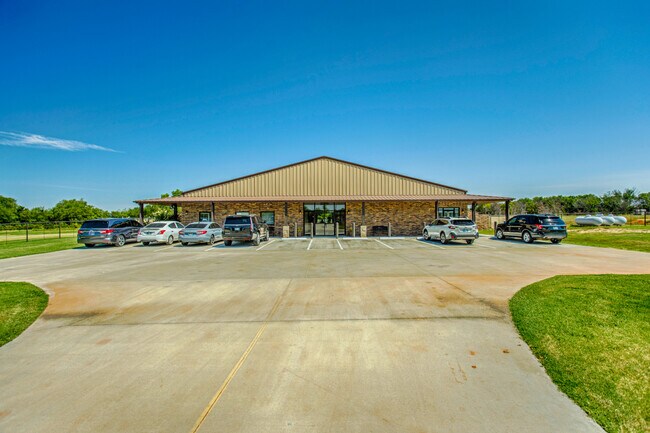
This Property Is For Sale
Property Detail
Hazel Dell Rd
000002011003000100
SW SE SE
Utilities
POTTAWATOMIE
B and X Area of moderate flood hazard, usually the area between the limits of the 100-year and 500-year floods.
Oklahoma
2024
10 AC
2025
Oklahoma East Area
501005
Other Market Areas
5,920 SF
Shawnee, OK
NEARBY LISTINGS FOR SALE OR LEASE
-
-
View all Mcloud listings for sale on LoopNet.com
DEMOGRAPHICS near Hazel Dell Rd
1 mile
3 mile
5 mile
2025 Total Population
200
1,531
6,662
2030 Population
208
1,586
6,914
Pop Growth 2025-2030
+ 4.00%
+ 3.59%
+ 3.78%
Average Age
40
41
41
2025 Total Households
77
577
2,503
HH Growth 2025-2030
+ 3.90%
+ 3.64%
+ 3.88%
Median Household Inc
$56,874
$59,721
$58,549
Avg Household Size
2.60
2.60
2.60
2025 Avg HH Vehicles
2.00
2.00
2.00
Median Home Value
$265,624
$228,448
$205,668
Median Year Built
1999
1999
1992
Nearby Places
Map Layers
Map Styles
 Street
 Aerial
Layers
 Traffic
 Biking
Places
Listings with unknown addresses are not visible on the map
- Restaurants
- Banks
- Shops
- Fitness
- Groceries
Nearby Properties
Address
Land Use
TOTAL SIZE
Lot Size
Zoning
Address
Land Use
TOTAL SIZE
Lot Size
Zoning
521,067 SF
97 AC
Address
Land Use
TOTAL SIZE
Lot Size
Zoning
8,178 SF
1 AC
Address
Land Use
TOTAL SIZE
Lot Size
Zoning
286,505 SF
33.78 AC
Address
Land Use
TOTAL SIZE
Lot Size
Zoning
50,000 SF
8.15 AC
Address
Land Use
TOTAL SIZE
Lot Size
Zoning
64,400 SF
4.93 AC
Address
Land Use
TOTAL SIZE
Lot Size
Zoning
25,064 SF
22.70 AC
CR
Address
Land Use
TOTAL SIZE
Lot Size
Zoning
40,600 SF
7.44 AC
Address
Land Use
TOTAL SIZE
Lot Size
Zoning
131,664 SF
19.93 AC
I1
Address
Land Use
TOTAL SIZE
Lot Size
Zoning
62,700 SF
5 AC
Address
Land Use
TOTAL SIZE
Lot Size
Zoning
28,000 SF
6.30 AC
NP
Address
Land Use
TOTAL SIZE
Lot Size
Zoning
26,010 SF
19.26 AC
Address
Land Use
TOTAL SIZE
Lot Size
Zoning
227,225 SF
22.34 AC
Address
Land Use
TOTAL SIZE
Lot Size
Zoning
8,241 SF
5.75 AC
Address
Land Use
TOTAL SIZE
Lot Size
Zoning
41,004 SF
42.44 AC
Address
Land Use
TOTAL SIZE
Lot Size
Zoning
21,605 SF
1.62 AC
Address
Land Use
TOTAL SIZE
Lot Size
Zoning
8,000 SF
2.50 AC
I1
Address
Land Use
TOTAL SIZE
Lot Size
Zoning
4,149 SF
31.58 AC
IP
Address
Land Use
TOTAL SIZE
Lot Size
Zoning
8.80 AC
NP
Address
Land Use
TOTAL SIZE
Lot Size
Zoning
6,111 SF
4 AC
Address
Land Use
TOTAL SIZE
Lot Size
Zoning
260 AC
Address
Land Use
TOTAL SIZE
Lot Size
Zoning
31,600 SF
5.50 AC
Address
Land Use
TOTAL SIZE
Lot Size
Zoning
6,400 SF
1 AC
Address
Land Use
TOTAL SIZE
Lot Size
Zoning
3,200 SF
1.25 AC
Address
Land Use
TOTAL SIZE
Lot Size
Zoning
3,800 SF
12.64 AC
IP
Address
Land Use
TOTAL SIZE
Lot Size
Zoning
2,400 SF
1.48 AC
Address
Land Use
TOTAL SIZE
Lot Size
Zoning
Address
Land Use
TOTAL SIZE
Lot Size
Zoning
4,520 SF
5 AC
Address
Land Use
TOTAL SIZE
Lot Size
Zoning
3,000 SF
2.41 AC
Address
Land Use
TOTAL SIZE
Lot Size
Zoning
The World's #1 Commercial Real Estate Marketplace
Connect with us
© 2026 CoStar Group
The information above has been obtained from sources believed reliable. While we do not doubt its accuracy we have not verified it and make no guarantee, warranty or representation about it. It is your responsibility to independently confirm its accuracy and completeness. Any projections, opinions, assumptions, or estimates used are for example only and do not represent the current or future performance of the property. The value of this transaction to you depends on tax and other factors which should be evaluated by your tax, financial, and legal advisors. You and your advisors should conduct a careful, independent investigation of the property to determine to your satisfaction the suitability of the property for your needs.